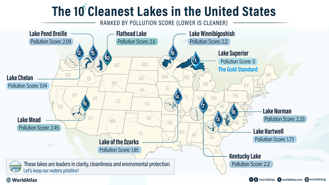
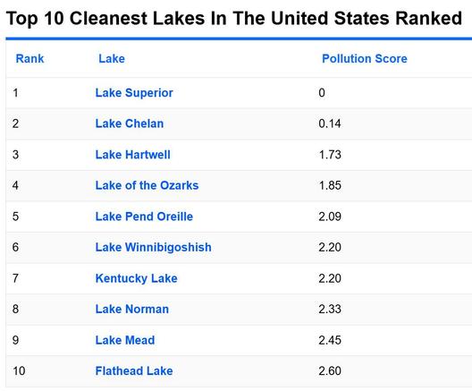
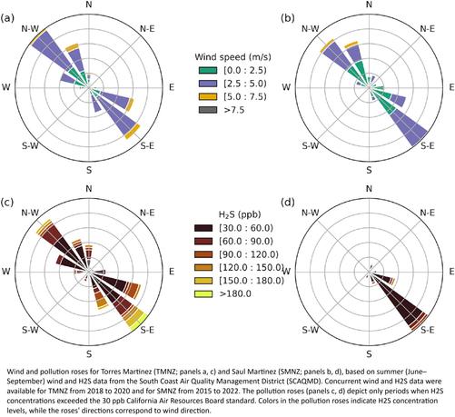
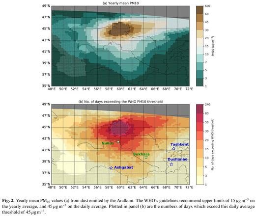
The 10 Cleanest Lakes In The United States
--
https://www.worldatlas.com/lakes/the-10-cleanest-lakes-in-the-united-states.html <-- shared technical article
--
https://www.lake.com/company/reports/cleanest-and-dirtiest-lakes-in-america/ <-- shared 2025 Cleanest and Dirtiest Lakes in America Report
--
[this post should not be seen as an endorsement of any specific organisation’s approach or views]
#water #hydrology #hydrography #waterquality #USA #CONUS #waterbody #best #worst #impaired #pollution #waterresources #cleanest #lake #waterchemistry #sampling #monitoring #NWQA #dissolvedoxygen #ammonia #lead #phosphorus #sulfate #totaldissolvedsolids #TDS #turbidity #pH #geography #hydrogeomorphology #management #planning #policy #farming #agriculture #waste #climatechange #agriculturalrunoff #drought #extremeweather
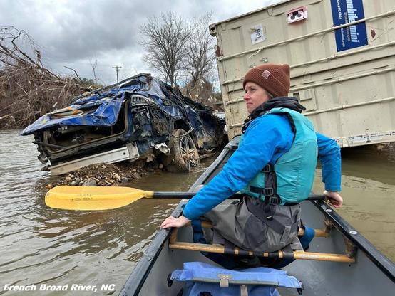
@Environmental Integrity Project
--
https://www.worldatlas.com/lakes/the-10-cleanest-lakes-in-the-united-states.html <-- shared technical article
--
https://www.lake.com/company/reports/cleanest-and-dirtiest-lakes-in-america/ <-- shared 2025 Cleanest and Dirtiest Lakes in America Report
--
[this post should not be seen as an endorsement of any specific organisation’s approach or views]
#water #hydrology #hydrography #waterquality #USA #CONUS #waterbody #best #worst #impaired #pollution #waterresources #cleanest #lake #waterchemistry #sampling #monitoring #NWQA #dissolvedoxygen #ammonia #lead #phosphorus #sulfate #totaldissolvedsolids #TDS #turbidity #pH #geography #hydrogeomorphology #management #planning #policy #farming #agriculture #waste #climatechange #agriculturalrunoff #drought #extremeweather
@Environmental Integrity Project