Open source geological #mapping with British Geological Survey
--
https://www.herengaanuku.govt.nz/our-work/publications/state-of-public-access <-- shared report
--
"This inaugural State of Public Outdoor Access Report, which provides a comprehensive snapshot of public access to the outdoors across Aotearoa..."
--
#spatial #mapping #pocketmaps #app #parcels #catalogue #easement #comprise #cadastre #outdooraccess #PublicLand #PrivateLand #accomodation #NewZealand #recreation #landuse #landtypes #outdoorspaces #access #legislation #framework #reserves #authority #paperroads #cycleways #bicycle #hunting #fishing #coast #coastal #mountains #commission #reporting #government #tangatawhenua #indigenous #firstnation #maori #localcouncils #communitygroups #landowners #publicaccess #education #environment #restoration #support #respect #landrights #walkways #tramping #trails #hiking #camping #services #land
@HerengaāNukuAotearoa | #HerengaāNukuAotearoa | #OutdoorAccessCommission
Evaluate Bin Sizes for Point Aggregation in #ArcGISPro 3.6 tinyurl.com/2y3t4urt
#spatial #analysis #data #GIS #esri #arcgis #mapping #GISchat #geospatial #TheScienceOfWhere @esri @arcgispro @esrifederalgovt @esrislgov @esritraining
this is a seriously cool map. mostly cause australia is right there, but also because it's a neat projection
via https://www.reddit.com/r/MapPorn/comments/1q4h4bq/one_ocean_world_map/
--
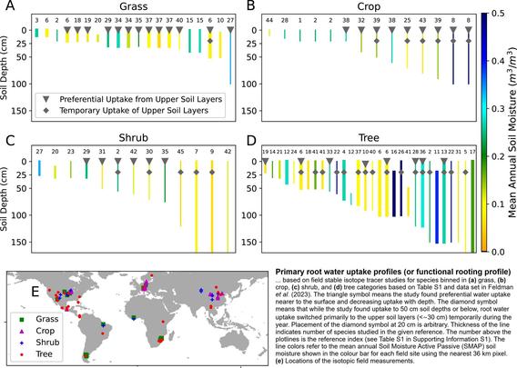
https://doi.org/10.1029/2022WR033814 <-- shared (2023) paper
--
#GIS #spatial #mapping #remotesensing #global #soil #moisture #earthobservation #Lband #satellite #landsurface #landuse #biosphere #hydrosphere #microwave #vegetation #botany #roots #agriculture #pluvial #rainfall #taproot #planthealth #foodsecurity #production #rootzones #spatialanalysis #spatiotemporal #grasslands #croplands #shrubs #trees #seasonal #water #hydrology #wateruptake #SMAP
@nasa @nasa Goddard @AGU
--
https://scottreinhardmaps.com/blogs/custom-mapping-projects/custom-reuters-open-source-mapping <-- shared technical article
--
#GIS #spatial #mapping #Reuters #news #publicmedia #media #maps #cartography #cartographer #opensource #opendata #Mapbox #MapLibre #Maputnik #Protomaps #newsservive #newsroom #news #tools #workflows #tutorials #overview #webmapping #newsorganisations #newsorganizations #automation #reporters #aesthetics #design #graphics #infographics
#Reuters | #OpenStreetMap | #OGC
Sometimes getting map data from government "open data portals" is not as easy as it should be. Thankfully, the excellent and free #QGIS desktop app has the QuickOSM plugin to allow fast and convenient downloading of data from #OpenStreetMap
To get the boundary of my county, I put the area in view, open QuickOSM plugin, select "Layer Extent", and search for boundary=administrative and name="Monroe County".
That's it! The county boundary appears, ready to use.
Everybody's going mapping...Mapping USA! Good news! The schedule for our annual virtual conference is live: https://openstreetmap.us/events/mapping-usa/2026/
#MappingUSA #OpenStreetMap #OSM #geospatial #mapping #opendata
palewire: First Basemap. “Create a shockingly fast and virtually free interactive map of the world using OpenStreetMap and PMTiles… This course is free. Previous experience working with Amazon Web Services and GitHub Actions will be useful, but anyone with a good attitude is qualified.”
https://rbfirehose.com/2026/01/06/palewire-first-basemap/Cuối tuần mình ra mắt **Land Hunter** – web app cho phép “đào” xuyên trái đất để tìm địa điểm đối xứng (antipode). Dùng React + Tailwind, Leaflet + react‑leaflet, animation Framer Motion. Đặc điểm: hiệu ứng “X‑Ray” hiển thị khu vực dưới chùm đèn, tính năng Auto‑Pilot đưa người dùng tới vùng đất, hệ thống “Passport” unlock badge khi tìm được kết nối đất‑đất hiếm. Đánh giá, góp ý UI & hiệu năng nhé! #WebDev #React #Mapping #SideProject #CôngNghệ #LậpTrình


