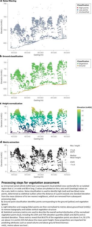
USGS CoNED (TopoBathy) WebMap Viewer & (Open) Data Downloader
--
https://topotools.cr.usgs.gov/topobathy_viewer/ <-- shared #USGS Viewer webmap & download selector
--
https://www.usgs.gov/coastal-changes-and-impacts/coned <-- shared USGS CoNED overview/entry page
--
[I used to shore dive in the Straits Of Juan de Fucca, Washington State side, and Crescent Lake - so I chose that area as a CoNED example to explore; good memories, including of the 18 Wheeler Burger with pie & coffee in Joyce, WA on drizzly days]
#GIS #spatial #mapping #remotesensing #model #modeling #CoastalNationalElevationDatabase #CoNED #elevation #topography #bathymetry #topobathy #opendata #openscience #fedscience #publicgood #usecase #naturalworld #coastal #coast #depth #hydrospatial #hydrography #download #shoreline #inundation #sedimenttransport #sealevelrise #SLR #stormsurge #models #modeling #extremeweather #tsunami #impact #risk #hazard #assessment #climatechange #geomorphology #geomorphometry #Restoration, #redevelopment #protection #cliff #flood #flooding #webmap
@USGS

I was thinking about #bathymetry recently. And have tentatively started a project. Here's a not-very-good #blogpost

https://tlohde.com/blog/2026/03/deep-thoughts/

note to self: #blender3d is complicated

#bathymetryMapping #lochTreig #dam #indieweb #map #maps #gis #qgis #lochs

deep thoughts

thinking abouth bathymetry

TopoBathy Open Standard - Bathymetric Attributed Grid (BAG) [OGC]
--
https://www.ogc.org/standards/bag/ <-- shared open OGC standard πŸ”—
--
https://www.hydroffice.org/bag/main <-- shared example of #opensource software to interact with the #opendata BAG format πŸ”—
--
[this post should not be considered an endorsement of a particular product and/or approach]
#GIS #spatial #mapping #opendata #opensource #standard #openstandard #BathymetricAttributedGrid #BAG #format #grid #raster #offshore #OGC #hydrography #submarine #survey #marine #ocean #bottom #hydrospatial #FAIR #openspecification #specification #bathymetry #depth #seafloor #vertical #datum #metadata #hydrographic
#OpenGeospatialConsortium

#30DayMapChallenge Day 28: Black

On this Black Friday, I found today’s theme in the depths of the Black Sea 🌊.

Using the OpenTopography DEM Downloader, I grabbed the Global Bathymetry SRTM15+ V2.1 dataset, calculated 100β€―m contours, and applied the Tanaka method with a style from the QGIS Hub plugin. 🎨

#QGIS #Cartography #OpenData #Bathymetry #BlackSea #GIS #Mapping