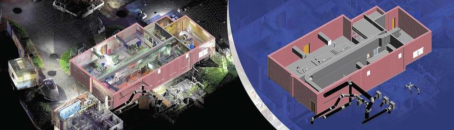
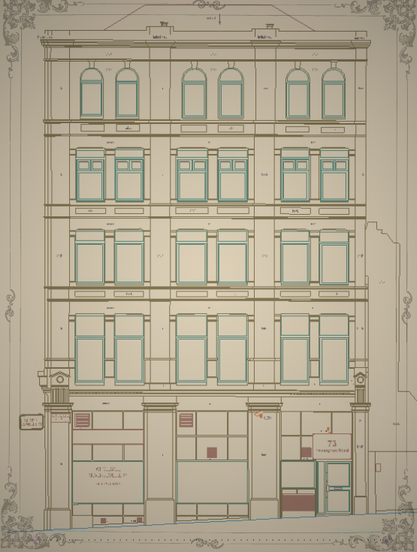
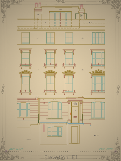
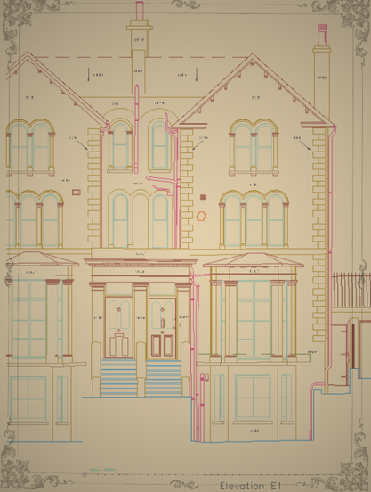
Open-source project announcement!

I’m inviting researchers, engineers, and open-source enthusiasts to check out my scientific work and contribute to a project that uses laser scanning (LiDAR) for 3D ventilation modeling in underground mines.

Article (MDPI Applied Sciences):
“Methodological Approach for Determining the Aerodynamic Resistance Using 3D Scanning: Application in Mine Ventilation Modeling”

https://doi.org/10.3390/app152111723

Open-source toolkits (Codeberg):

3D Ventilation Scanning — aerodynamic modeling, VentSim integration, ect.

Cloud Reduction — point cloud filtering and alpha-shape surface extraction

Both projects are Python-based, modular, and open for collaboration.
If you work with mine ventilation, tunnel modeling, or 3D point clouds, your feedback or contributions are very welcome!!

Codeberg repositories:

https://codeberg.org/EngLibre/3d-ventilation-scanning.git

https://codeberg.org/EngLibre/cloud_reduction.git

Let’s advance open scientific tools for mining engineering and environmental modeling together!

#OpenSource #Codeberg #Python #LiDAR #3DScanning #PointCloud #MineVentilation #VentSim #MiningEngineering #UndergroundMining #Geospatial #Geoinformatics #CFD #FluidDynamics #EngineeringResearch #ScientificComputing #OpenScience #DigitalTwin #MeshGeneration #AlphaShape #DataReduction #MiningTech #SustainableMining #VentilationModeling #TunnelEngineering #MineSafety #ResearchSoftware #OpenResearch #FOSS #LaserScanning #AppliedSciences #MDPI #MineModeling

Excited to share a glimpse into my latest architectural elevation drawings✨️

My aim is always to blend precision with elegance, and I feel these pieces truly embody that spirit.

#Architecture #2Ddrawing #Elevations #Portfolio #NewProjects #laserscanning #cad #BIM #outsourcingfirm

What a year it's been!🎉 Feeling immense gratitude and pride as I look back at some of my latest architectural elevation drawings. Each line, every detail, crafted with passion and precision.

Ready to jump into new challenges and projects! #Architecture #Elevations #Portfolio #2Ddrawing #CADdrafting #geodesy #pointcloud #laserscanning #survey

Is there a way to guide normal calculation of points in 3d space e.g. via placing points that are guaranteed to be "outside" of the mesh? Cloud Compare works with spanning trees, but I do not get correct results in complex models.

#ComputerGraphics #Photogrammetry #LaserScanning #3D

Discover precision with top 3D laser scanning services in London! 🏙️📏
🔗 Discover more—link in bio!

https://kershmedia.co.uk/3d-scanning-surveyors-london/

#laserscanning #surveyors #londonrealestate #constructiontech #3dsurvey

Leading 3D Laser Scanning Surveyors in London - Kersh Media

Find top-rated 3D laser scanning surveyors in London. Get high-precision scans for construction, engineering & more. Fast turnaround, competitive quotes.

Kersh Media
Around the 3D Technology Industry: Industrial Metaverse, 3D Tour, Laser Scanning

Every week, we highlight stories from friends around the internet that put a spotlight on the latest in the 3D technology industry. These stories can take many different forms, whether they be about a

Happy New Year to all #landsurveyors and friends! ✨️🍾 Wishing you amazing and creative opportunities this year 🎊

#cad #2Ddrawing #architecture #laserscanning #pointcloud #surveyor #measuredbuildingsurvey #geodesy #maps #2Dplans

Before you continue to YouTube