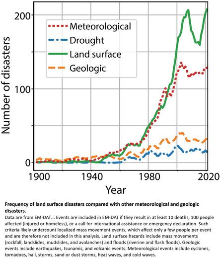
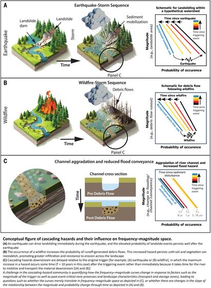
Characterizing Wildfire Behavior With ECOSTRESS Land Surface Temperature Across Four California Case Studies
--
https://doi.org/10.1016/j.ecoinf.2026.103777 <-- shared paper
--
#GIS #spatial #mapping #ECOSTRESS #remotesensing #earthobservation #wildfire #increased #frequency #intensity #forestfire #monitoring #hotspot #detection #Rateofspread #HotspotBurn #severity #spatialanalysis #spatiotemporal #VIIRS #fireradiativepower #FRP #landsurface #temperature #California #casestudy #burn #severity #dNBR #landsat #satellite #WesternUSA #extremeweather #climatechange #water #hydrology #hydrometeorology #drought #humanactivity #humanimpacts #ECOsystemSpaceborneThermalRadiometerExperimentonSpaceStation #ISS #spacestation #LST #rateofspread
@nasa
--
https://doi.org/10.1016/j.ecoinf.2026.103777 <-- shared paper
--
#GIS #spatial #mapping #ECOSTRESS #remotesensing #earthobservation #wildfire #increased #frequency #intensity #forestfire #monitoring #hotspot #detection #Rateofspread #HotspotBurn #severity #spatialanalysis #spatiotemporal #VIIRS #fireradiativepower #FRP #landsurface #temperature #California #casestudy #burn #severity #dNBR #landsat #satellite #WesternUSA #extremeweather #climatechange #water #hydrology #hydrometeorology #drought #humanactivity #humanimpacts #ECOsystemSpaceborneThermalRadiometerExperimentonSpaceStation #ISS #spacestation #LST #rateofspread
@nasa