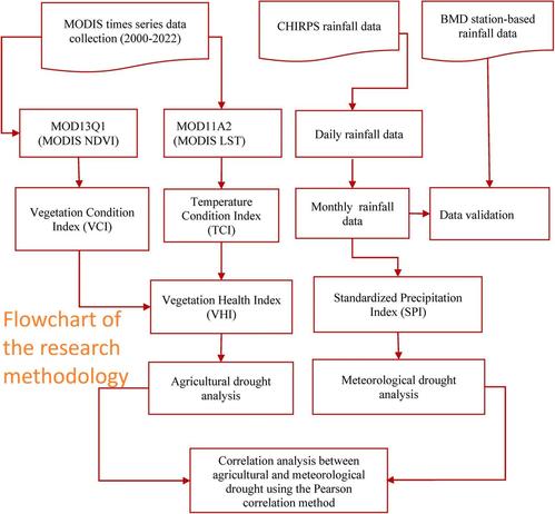
Half Of European Municipalities Have Fewer Inhabitants Than 60 Years Ago
--
https://correctiv.org/aktuelles/2026/04/21/die-haelfte-der-europaeischen-gemeinden-hat-weniger-einwohner-als-vor-60-jahren/ <-- shared technical / spatiotemporal article
--
https://data.jrc.ec.europa.eu/dataset/37fcacbf-12e2-4b31-b1af-83117a74b2c7 <-- shared European Joint Research Centre (JRC) ARDECO Local Population Time-Series – 1961-2024
--
#GIS #spatial #mapping #emptyspain #demographics #population #agingpopulation #declining #birthrate #immigration #emigration #shrinking #interactive #webmap #spatialanalysis #spatiotemporal #Europe #geostatistics #logistics #rural #urban #city #transportation #cost #economics #services #infrastructure #workers #qualityoflife #planning
@JointResearchCentre #JRC @europeancommission @correctiv_org
--
https://correctiv.org/aktuelles/2026/04/21/die-haelfte-der-europaeischen-gemeinden-hat-weniger-einwohner-als-vor-60-jahren/ <-- shared technical / spatiotemporal article
--
https://data.jrc.ec.europa.eu/dataset/37fcacbf-12e2-4b31-b1af-83117a74b2c7 <-- shared European Joint Research Centre (JRC) ARDECO Local Population Time-Series – 1961-2024
--
#GIS #spatial #mapping #emptyspain #demographics #population #agingpopulation #declining #birthrate #immigration #emigration #shrinking #interactive #webmap #spatialanalysis #spatiotemporal #Europe #geostatistics #logistics #rural #urban #city #transportation #cost #economics #services #infrastructure #workers #qualityoflife #planning
@JointResearchCentre #JRC @europeancommission @correctiv_org