Rock Weathering Can Counteract River CO2 Emissions Induced By Permafrost Thaw
--
https://doi.org/10.1038/s41586-026-10664-8 <-- shared paper
--
H/T @aaron Bufe
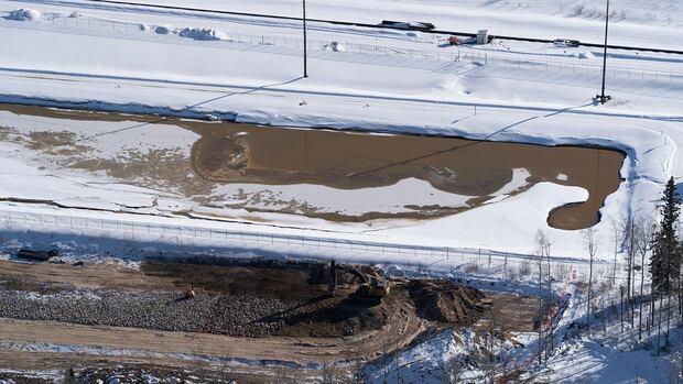
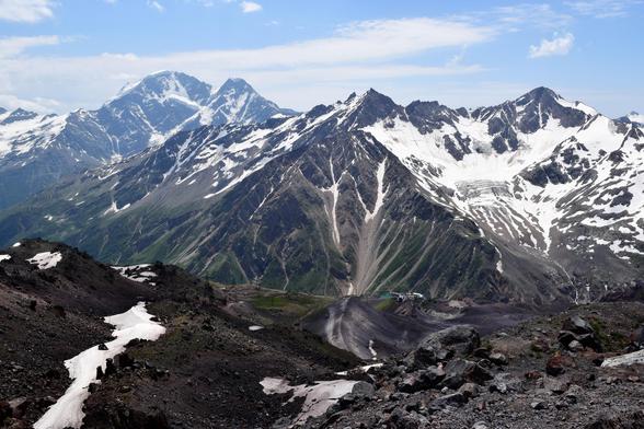
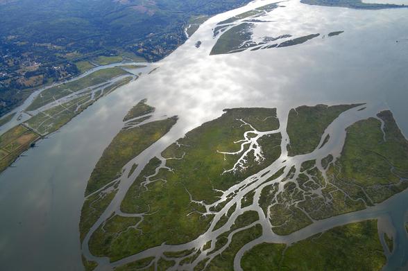
“[The researchers] measured carbon emissions and water chemistry in 50 headwater rivers draining 780,000 km² of the Tibetan Plateau.
The rivers flow in landscapes underlain by continuous permafrost and landscapes in which the permafrost has retreated since the last glacial maximum. They collect[ed] organic carbon from soils and dissolved inorganic carbon that is fixed by rock-weathering.
Where the permafrost cover is continuous, rivers emit CO2 from degrading (permafrost) soil carbon. Weathering reactions in these catchments are relatively slow.
In landscapes with (almost) no permafrost, carbon fluxes from weathering are faster than CO2 emissions from rivers.
Thus, as permafrost landscapes transition to landscapes without permafrost cover, chemical weathering reactions may play an ever more important role in riverine carbon cycling.
Interestingly, weathering can affect the carbon cycle in different ways. Where sulfide minerals are present, weathering reactions can emit CO2. Where silicate minerals dominate, weathering draws down CO2 from the atmosphere…”
--
“Climate-induced permafrost thaw unlocks large stores of organic carbon that are mineralized and emitted as carbon dioxide (CO2) from rivers to the atmosphere. Concurrently, warming and permafrost thaw can increase mineral weathering rates, thus affecting the release and sequestration of inorganic carbon. Yet how these biological and geological carbon cycles interact and jointly affect CO2 dynamics (emission compared with drawdown) in permafrost rivers remains unknown. Here [they] combine[d] CO2 emissions, organic and inorganic solute concentrations, dual carbon isotopes (δ13C–Δ14C) and geochemical modelling to infer how permafrost thaw may affect river biogeochemistry over decades to centuries across the Qinghai–Tibet Plateau. Leveraging a gradient of thermal permafrost degradation, we find that river CO2 emissions decline, whereas solute fluxes from rock weathering increase with decreasing permafrost cover. Across this region, net CO2 drawdown fluxes from rock weathering are about 35% of river CO2 emissions, varying from around 15% in catchments with continuous permafrost to more than 100% in catchments with discontinuous or isolated permafrost. Thus, carbon fluxes from chemical weathering may become increasingly important with ongoing permafrost thaw, potentially even outpacing river CO2 emissions. [Their] findings disentangle the interplay between biological and geological carbon fluxes that are important for the cryosphere and the global carbon cycle…”
#permafrost #melting #thaw #climatechange #warming #Tibet #TibetanPlateau #Qinghai #water #hydrology #carbonemissions #CO2 #emissions #waterchemistry #waterquality #cryosphere #sediment #sedimentation #weathering #rock #carbon #river #riverine #carboncyling #geochemistry #biology #geology #soil
--
https://doi.org/10.1038/s41586-026-10664-8 <-- shared paper
--
H/T @aaron Bufe
“[The researchers] measured carbon emissions and water chemistry in 50 headwater rivers draining 780,000 km² of the Tibetan Plateau.
The rivers flow in landscapes underlain by continuous permafrost and landscapes in which the permafrost has retreated since the last glacial maximum. They collect[ed] organic carbon from soils and dissolved inorganic carbon that is fixed by rock-weathering.
Where the permafrost cover is continuous, rivers emit CO2 from degrading (permafrost) soil carbon. Weathering reactions in these catchments are relatively slow.
In landscapes with (almost) no permafrost, carbon fluxes from weathering are faster than CO2 emissions from rivers.
Thus, as permafrost landscapes transition to landscapes without permafrost cover, chemical weathering reactions may play an ever more important role in riverine carbon cycling.
Interestingly, weathering can affect the carbon cycle in different ways. Where sulfide minerals are present, weathering reactions can emit CO2. Where silicate minerals dominate, weathering draws down CO2 from the atmosphere…”
--
“Climate-induced permafrost thaw unlocks large stores of organic carbon that are mineralized and emitted as carbon dioxide (CO2) from rivers to the atmosphere. Concurrently, warming and permafrost thaw can increase mineral weathering rates, thus affecting the release and sequestration of inorganic carbon. Yet how these biological and geological carbon cycles interact and jointly affect CO2 dynamics (emission compared with drawdown) in permafrost rivers remains unknown. Here [they] combine[d] CO2 emissions, organic and inorganic solute concentrations, dual carbon isotopes (δ13C–Δ14C) and geochemical modelling to infer how permafrost thaw may affect river biogeochemistry over decades to centuries across the Qinghai–Tibet Plateau. Leveraging a gradient of thermal permafrost degradation, we find that river CO2 emissions decline, whereas solute fluxes from rock weathering increase with decreasing permafrost cover. Across this region, net CO2 drawdown fluxes from rock weathering are about 35% of river CO2 emissions, varying from around 15% in catchments with continuous permafrost to more than 100% in catchments with discontinuous or isolated permafrost. Thus, carbon fluxes from chemical weathering may become increasingly important with ongoing permafrost thaw, potentially even outpacing river CO2 emissions. [Their] findings disentangle the interplay between biological and geological carbon fluxes that are important for the cryosphere and the global carbon cycle…”
#permafrost #melting #thaw #climatechange #warming #Tibet #TibetanPlateau #Qinghai #water #hydrology #carbonemissions #CO2 #emissions #waterchemistry #waterquality #cryosphere #sediment #sedimentation #weathering #rock #carbon #river #riverine #carboncyling #geochemistry #biology #geology #soil