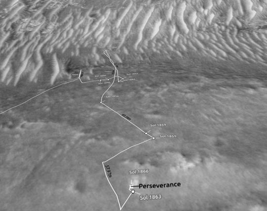
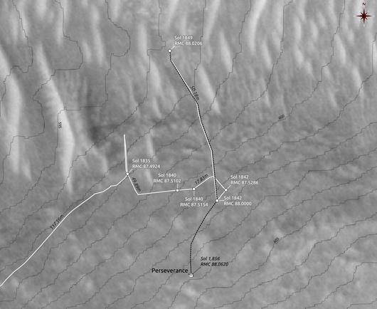
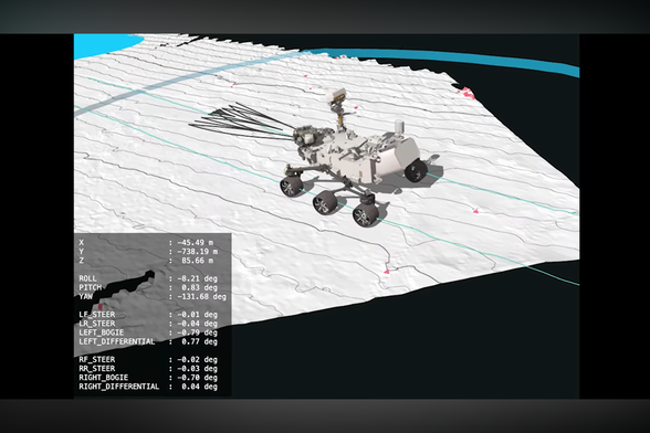
🔴 Mars | Dunes in Crater in Planum Chronium | HiRISE

⛏️ Digging in the archives

ESP_059324_1200, 24 March 2019 🔭

source: www.uahirise.org/ESP_059324_1...

Credit: #NASA/ #JPL-Caltech/ #UArizona/ Jackie Branc © CC BY

#Mars #dunes #crater #PlanumChronium #HiRISE

🔴 Did you know #Mars is still changing, and you can see it in 3D? Processes like erosion and rock breakdown happen on Mars, too! Using ultra-sharp #HiRISE images, Sarah S Sutton, Matthew Chojnacki, Alfred McEwen and co-researchers capture detailed 3D views of dunes and mysterious dark streaks as they evolve. 🛰️Explore the animated views and article at https://doi.org/10.25422/azu.data.19555210 and https://doi.org/10.3390/rs14102403. Image: Sutton et al. (2022). CC BY 4.0. #OpenData #OpenScience #PlanetaryScience

#Perseverance: an increasingly autonomous #rover... (1/2)

Analysis of images acquired by the #HiRISE camera on the #Mars Reconnaissance Orbiter, combined with the use of altimetry data, enabled a visual language model to plan the #route of the Perseverance rover. After verification, the commands were transmitted to Mars. For the very first time in its history, Perseverance followed a trajectory designed by #AI! 👏

More info: https://scitechdaily.com/nasas-perseverance-mars-rover-makes-history-with-ai-planned-drive/

#Perseverance : un #rover toujours plus autonome ... (1/2)

L'analyse des images acquises par la caméra #HiRISE de la sonde #Mars Reconnaissance Orbiter, combinée à l'utilisation de données altimétriques, ont permis à un modèle de language visuel de planifier l'#itinéraire du rover Perseverance. Après vérification, les commandes ont été transmises sur Mars. Pour la toute première fois de son histoire, Perseverance a suivi une trajectoire dessinée par #IA ! 👏

Infos+ : https://scitechdaily.com/nasas-perseverance-mars-rover-makes-history-with-ai-planned-drive/

So, #Perseverance has now come back closer to the planned route, after a short deviation to the west, and is about 140m away from Lac De Charmes. It should be there within one sol, if its present location proves to be not of much interest to the team.

Map drawn using #QGIS, #NASA's #MMGIS, #USGS and #HiRISE data

#Mars2020 #Solarocks #Space

Back then, some of us were competing on who will figure out first where the #MarsHelicopter had landed, by using the very first batch of images arriving from Mars to provide solid proof.

Here is one such proof of mine, superimposing one of #Ingenuity's landing images on an #MMGIS map based on #HiRISE images, for #Flight28 :

#Ingenuity #Mars20202 #NASA #Solarocks #Space

A High-Resolution Camera Orbiting Mars Captured Its 100,000th Photo

NASA's MRO is nearly 20 years old.

PetaPixel

Apparently that low area passing through regolith mega-ripples wasn't interesting enough for #Perseverance, and it has now moved further SW to an area with about the same altitude. The altitudes shown on the map are relative to the landing location.

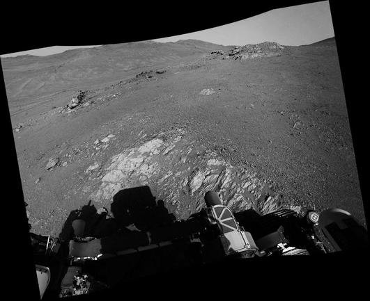
Processed, undistorted, leveled NAVCAM_LEFT mosaic
looking SSW (198°) from RMC 82.5380
Sol 1709, LMST: 15:15:29
One original: https://mars.nasa.gov/mars2020-raw-images/pub/ods/surface/sol/01709/ids/edr/browse/ncam/NLF_1709_0818666294_508ECM_N0825380NCAM03709_07_195J01.png

Credit: #NASA/JPL-Caltech/65dBnoise

#QGIS #MMGIS #USGS #HiRISE #NASA #Mars2020 #Solarocks #Space

As anticipated, #Perseverance has now reached the center of the area of lowest elevation along its route to Lac De Charmes, and has placed a nice flat piece of bedrock at (robotic) arm's length (but not inside its workspace).

Processed, undistorted, leveled, cropped NAVCAM_LEFT mosaic
looking NNW (342°) from RMC 82.3986
Sol 1707, LMST: 13:55:33
Original: https://mars.nasa.gov/mars2020-raw-images/pub/ods/surface/sol/01707/ids/edr/browse/ncam/NLF_1707_0818483817_506ECM_N0823986NCAM03707_01_190J01.png

Credit: #NASA/JPL-Caltech/65dBnoise

#Mars2020 #Solarocks #Space #QGIS #USGS #HiRISE #MMGIS

#Perseverance either drove into a dead end and is now surrounded by heaps of sand, or found something interesting there, which we don't see yet…

Over-processed to show sand patterns, undistorted, leveled, cropped NAVCAM_RIGHT
looking ENE (71°) from RMC 82.2866
Sol 1704, LMST: 12:36:19

Original: https://mars.nasa.gov/mars2020-raw-images/pub/ods/surface/sol/01704/ids/edr/browse/ncam/NRF_1704_0818212608_691ECM_N0822866NCAM02704_01_195J01.png

Credit: #NASA/JPL-Caltech/65dBnoise

#Mars2020 #Solarocks #Space #QGIS #MMGIS #USGS #HiRISE