Climate Warming and Ice Weakening Trigger Alpine Glacier Collapses - The Marmolada Case [Dolomites, Northern Italy]
--
https://doi.org/10.1029/2025GL121279 <-- shared paper
--
https://doi.org/10.5194/nhess-25-3027-2025 <-- shared technical article
--
https://en.wikipedia.org/wiki/2022_Marmolada_serac_collapse <-- shared Wikipedia page
--
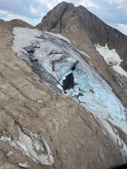
[anecdotal – in the early 1990s, I chose to spend a winter as a ski bum/guide, living in Arabba, Dolomites, Sud Tyrol; I still remember the excellent days when I got to ski on the Marmolada]
--
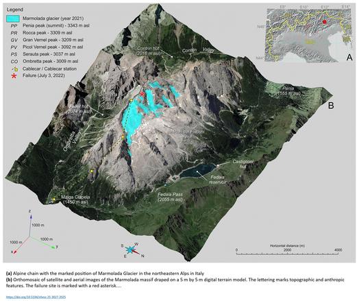
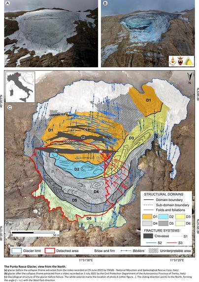
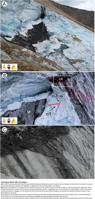
“PLAIN LANGUAGE SUMMARY: On 3 July 2022, a portion of the Marmolada glacier, near Punta Rocca, collapsed and caused the death of 11 mountaineers. This dramatic event had a considerable impact on the media, and authorities were concerned about the risk that other collapses might occur in this and other glaciers of the Dolomites, a well-renowned mountain region of the southeastern Alps and one of the UNESCO World Heritage sites. [They] analyzed the possible causes of the collapse by developing a three-dimensional thermo-mechanical model. The analysis concluded that the collapse was caused by increased internal ice temperature and the development of a dense network of fractures, reducing the ice shear strength, with melting water that possibly contributed by increasing the basal pressure. [They] also showed that collapsing conditions can be identified with a simplified model version approximating the sliding basal surface as a plane with a slope equal to the surface slope. The developed approach can be used in hazard identification and risk analysis of mountain glaciers…”
#EngineeringGeology #RockMechanics #GlacierCollapse #RiskAssessment #italy #Dolomites #SudTyrol #glacier #melting #massmovement #risk #hazard #analysis #Marmolada #glaciercollapse #cryosphere #warning #mitigation #hazardassessment #alpine #climatechange #globalwarming #massloss #instability #model #modeling #thermomechanical #spatialanalysis #temperature #parameters #ice #shearstrength #water #hydrology #hydrography #basal #waterpressure #meltwater #fracturing #riskanalysis #mountainglaciers
--
https://doi.org/10.1029/2025GL121279 <-- shared paper
--
https://doi.org/10.5194/nhess-25-3027-2025 <-- shared technical article
--
https://en.wikipedia.org/wiki/2022_Marmolada_serac_collapse <-- shared Wikipedia page
--
[anecdotal – in the early 1990s, I chose to spend a winter as a ski bum/guide, living in Arabba, Dolomites, Sud Tyrol; I still remember the excellent days when I got to ski on the Marmolada]
--
“PLAIN LANGUAGE SUMMARY: On 3 July 2022, a portion of the Marmolada glacier, near Punta Rocca, collapsed and caused the death of 11 mountaineers. This dramatic event had a considerable impact on the media, and authorities were concerned about the risk that other collapses might occur in this and other glaciers of the Dolomites, a well-renowned mountain region of the southeastern Alps and one of the UNESCO World Heritage sites. [They] analyzed the possible causes of the collapse by developing a three-dimensional thermo-mechanical model. The analysis concluded that the collapse was caused by increased internal ice temperature and the development of a dense network of fractures, reducing the ice shear strength, with melting water that possibly contributed by increasing the basal pressure. [They] also showed that collapsing conditions can be identified with a simplified model version approximating the sliding basal surface as a plane with a slope equal to the surface slope. The developed approach can be used in hazard identification and risk analysis of mountain glaciers…”
#EngineeringGeology #RockMechanics #GlacierCollapse #RiskAssessment #italy #Dolomites #SudTyrol #glacier #melting #massmovement #risk #hazard #analysis #Marmolada #glaciercollapse #cryosphere #warning #mitigation #hazardassessment #alpine #climatechange #globalwarming #massloss #instability #model #modeling #thermomechanical #spatialanalysis #temperature #parameters #ice #shearstrength #water #hydrology #hydrography #basal #waterpressure #meltwater #fracturing #riskanalysis #mountainglaciers