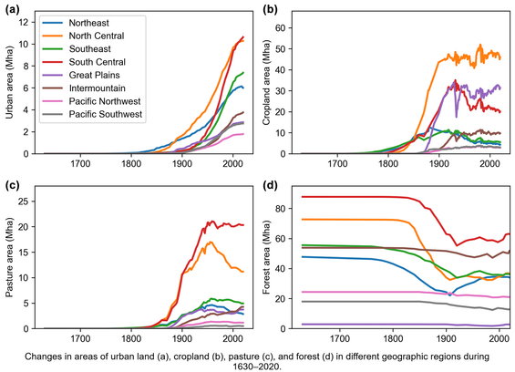
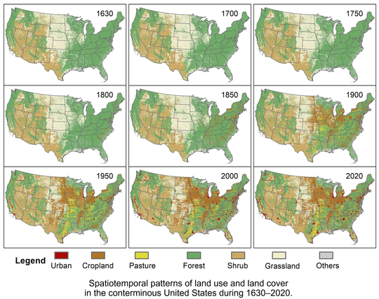
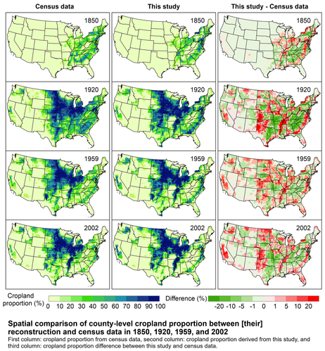
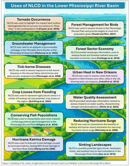
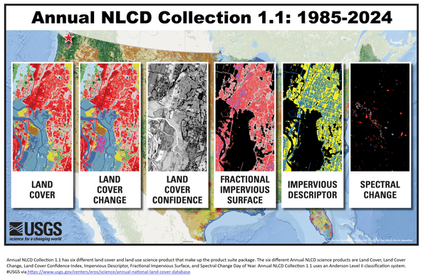
🌱 #EvoLand C5 candidate prototype develops high-resolution Gross Primary Productivity data (10-daily, 10 m) for #grassland and #cropland across Europe.

🌡️ A key improvement is the refined drought and temperature stress component, which better captures the impact of extreme weather on vegetation productivity.

🌐 Explore our website and see how to connect with the Results Portal and uncover more about C5 https://www.evo-land.eu/results-portal/

@EU_HaDEA @EU_ENV @DLR @cnes

One-sixth of the planet’s cropland has toxic levels of one or more metals

A review of tens of thousands of soil samples from Earth reveals high concentrations of arsenic, cadmium, and lead in the pedosphere

EL PAÍS English
About 15% of world’s cropland polluted with toxic metals, say researchers

Scientists sound the alarm over substances such as arsenic and lead contaminating soils and entering food systems

The Guardian

About 15% of World's #Cropland Polluted With #Toxic Metals, Say Researchers - #Slashdot

Well, that is **really a BAD new**!!!

https://news.slashdot.org/story/25/04/18/2345235/about-15-of-worlds-cropland-polluted-with-toxic-metals-say-researchers

About 15% of World's Cropland Polluted With Toxic Metals, Say Researchers - Slashdot

About one sixth of global cropland is contaminated by toxic heavy metals, researchers have estimated, with as many as 1.4 billion people living in high-risk areas worldwide. From a report: Approximately 14 to 17% of cropland globally -- roughly 242m hectares -- is contaminated by at least one toxic ...

Hydrogeologic Investigation, Framework, And Conceptual Flow Model Of The Antlers Aquifer, Southeastern Oklahoma, 1980–2022
--
https://doi.org/10.3133/sir20255013 <-- shared USGS publication
--
https://waterdata.usgs.gov/nwis <-- shared USGS National Water Information System (NWIS) database
--
https://doi.org/10.5066/P14C6QFS <-- shared associated USGS open data release
--
#GIS #spatial #mapping #fedscience #water #hydrology #wateresources #pump #pumping #groundwater #AntlersAquifer #aquifer #Oklahoma #model #flow #test #flowmodel #yield #wateruse #watersecurity #climate #weather #recharge #precipitation #rainfall #TDS #waterquality #ions #potentiometric #geology #monitoring #planning #regulatory #agriculture #farming #cropland #spatialanalysis #spatiotemporal #fedscience
@USGS
Hydrogeologic investigation, framework, and conceptual flow model of the Antlers aquifer, southeastern Oklahoma, 1980–2022

The 1973 Oklahoma Groundwater Law (Oklahoma Statute §82–1020.5) requires that the Oklahoma Water Resources Board conduct hydrologic investigations of the State’s groundwater basins to support a determination of the maximum annual yield for each groundwater basin. Every 20 years, the Oklahoma Water Resources Board is required to update the hydrologic investigation on which the maximum annual yield determinations were based. The maximum annual yield allocated per acre of land is used to set the equal-proportionate share pumping rate. The maximum annual yield of 5,913,600 acre-feet per year and equal-proportionate-share of 2.1 acre-feet per acre per year currently (2025) in place for the Antlers aquifer were issued by the Oklahoma Water Resources Board on February 14, 1995. Because more than 20 years have elapsed since the 1995 final order for the Antlers aquifer was issued, the U.S. Geological Survey, in cooperation with the Oklahoma Water Resources Board, completed an in-depth hydrologic...