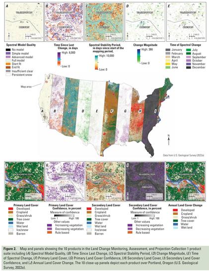
Thirty Years of the U.S. National Land Cover Database - Impacts and Future Direction
--
https://doi.org/10.14358/PERS.25-00121R2 <-- shared paper
--
“Editor's choice article for the October Issue of Photogrammetric Engineering and Remote Sensing.”
#GIS #spatial #mapping #remotesensing #opendata #earthobservation #landcover #USA #NLCD #MRLCC #history #datacollection #impervioussurface #classifaction #landform #forestcanopy #fedscience #fedservice #deeplearning #AI #spatialanalysis #change #monitoring #usecase #research #landmanagement #management #policy #planning #support #agriculture #urbanplanning #environment #ecosystems #biodiversity #conservation #water #hydrology #humanhealth #risk #hazard #soils #naturalhazard #spatiotemporal #landchange #forestry #watermanagement #waterquality #publicsafety #groundwater #NCLA #wildfire #stormwater #extremeweather
#USGS #EROS #NASA #USFS
--
https://doi.org/10.14358/PERS.25-00121R2 <-- shared paper
--
“Editor's choice article for the October Issue of Photogrammetric Engineering and Remote Sensing.”
#GIS #spatial #mapping #remotesensing #opendata #earthobservation #landcover #USA #NLCD #MRLCC #history #datacollection #impervioussurface #classifaction #landform #forestcanopy #fedscience #fedservice #deeplearning #AI #spatialanalysis #change #monitoring #usecase #research #landmanagement #management #policy #planning #support #agriculture #urbanplanning #environment #ecosystems #biodiversity #conservation #water #hydrology #humanhealth #risk #hazard #soils #naturalhazard #spatiotemporal #landchange #forestry #watermanagement #waterquality #publicsafety #groundwater #NCLA #wildfire #stormwater #extremeweather
#USGS #EROS #NASA #USFS