Fiery Fall Color in Southern Chile http://dlvr.it/TSG3M1 #EarthObservatory #LandCover #Landsat9 #Vegetation
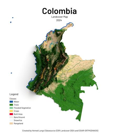
Colombia Landcover Map 2024 🇨🇴🗺️
From Andean glaciers to Amazon rainforests — Colombia's land cover mapped using ESRI Landcover 2024 by @impactobservatory & @esri, and CGIAR-SRTM DEM by divagis.
🛠️ QGIS · Blender
#Cartography #Colombia #Landcover #data #gischat #qgis #b3d
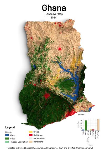
🌍 Ghana Landcover Map 2024 🇬🇭🗺️
From tropical forests to northern savannas — Ghana's landscape mapped using ESRI Landcover 2024 by @impactobservatory & @esri, and SRTM90 DEM by @opentopography.
🛠️ QGIS · Blender 🧭 Hemed Lungo
#GIS #Cartography #Ghana #Landcover #Geospatial
From tropical forests to northern savannas — Ghana's landscape mapped using ESRI Landcover 2024 by @impactobservatory & @esri, and SRTM90 DEM by @opentopography.
🛠️ QGIS · Blender 🧭 Hemed Lungo
#GIS #Cartography #Ghana #Landcover #Geospatial

🌍 Ghana Landcover Map 2024 🇬🇭🗺️
From tropical forests to northern savannas — Ghana's landscape mapped using ESRI Landcover 2024 by @impactobservatory & @esri, and SRTM90 DEM by @opentopography.
🛠️ QGIS · Blender 🧭 Hemed Lungo
#GIS #Cartography #Ghana #Landcover #Geospatial
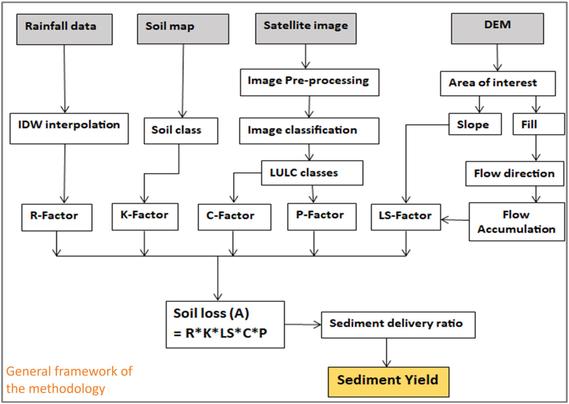
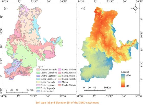
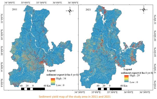
Detecting Land Use And Land Cover Changes And Quantifying Soil Erosion And Sediment Export Using GIS And Remote Sensing In The GERD Catchment, Ethiopia
--
https://doi.org/10.1016/j.iswcr.2026.100657 <-- shared paper
--
https://infonile.org/en/2023/05/battling-for-survival-along-the-warming-source-of-the-blue-nile/ <-- shared technical media article
--
https://doi.org/10.1007/978-3-031-65241-7_4 <-- shared technical book chapter
--
https://doi.org/10.3390/rs8121020 <-- shared 2016 paper
--
#landuse #landcover #RUSLE #model #soil #erosion #sedimentation #GERD #catchment #NorthAfrica #Ethiopia #AbbayBasin #sustainability #landmanagement #agriculture #farmland #foodsecurity #water #hydrogology #reservior #watermanagement #watersecurity #waterresources #catchment #GrandEthiopianRenaissanceDam #BlueNile #hydrography #impoundment #GIS #spatial #mapping #remotesensing #earthobservation #thematic #spatialanalysis #spatiotemporal #landsat #elevation #DEM #CHIRPS #rainfall #precipitation #LULC #AI #forest #grazing #grassland #field #crops #cropland #waterbodies #urban #biophysical #risk #hazard #mitigation #soilquality
--
https://doi.org/10.1016/j.iswcr.2026.100657 <-- shared paper
--
https://infonile.org/en/2023/05/battling-for-survival-along-the-warming-source-of-the-blue-nile/ <-- shared technical media article
--
https://doi.org/10.1007/978-3-031-65241-7_4 <-- shared technical book chapter
--
https://doi.org/10.3390/rs8121020 <-- shared 2016 paper
--
#landuse #landcover #RUSLE #model #soil #erosion #sedimentation #GERD #catchment #NorthAfrica #Ethiopia #AbbayBasin #sustainability #landmanagement #agriculture #farmland #foodsecurity #water #hydrogology #reservior #watermanagement #watersecurity #waterresources #catchment #GrandEthiopianRenaissanceDam #BlueNile #hydrography #impoundment #GIS #spatial #mapping #remotesensing #earthobservation #thematic #spatialanalysis #spatiotemporal #landsat #elevation #DEM #CHIRPS #rainfall #precipitation #LULC #AI #forest #grazing #grassland #field #crops #cropland #waterbodies #urban #biophysical #risk #hazard #mitigation #soilquality
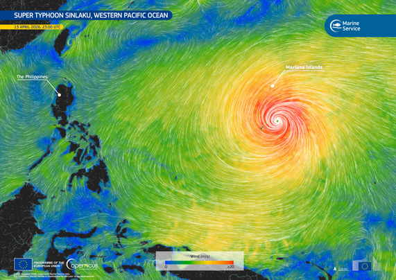
Super Typhoon Sinlaku hit the Mariana Islands in the Pacific Ocean
#Agriculture #Atmosphere #Land #Landcover #MarineEnvironment #SevereStorms #Tornadoes #Typhoons
⏩ 2 new pictures from Copernicus https://commons.wikimedia.org/wiki/Special:ListFiles?limit=2&user=OptimusPrimeBot&ilshowall=1&offset=20260416120609
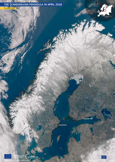
The Scandinavian Peninsula in April 2026
▶️ 1 new picture from Copernicus https://commons.wikimedia.org/wiki/File:The_Scandinavian_Peninsula_in_April_2026_%28Copernicus_2026-04-14%29.png
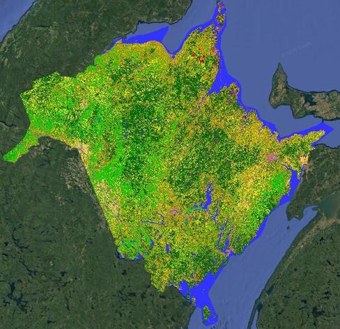
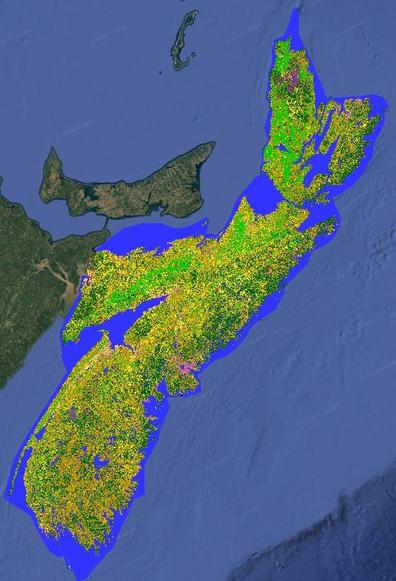
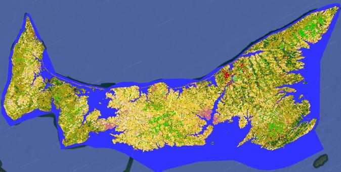
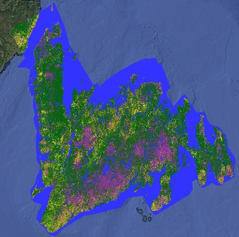
UPDATE: The provinces of New Brunswick, Nova Scotia, Prince Edward Island & Newfoundland are done & available to download. #cropmap25 #CdnAg #Landcover #RemoteSensing
https://open.canada.ca/data/en/dataset/ba2645d5-4458-414d-b196-6303ac06c1c9
https://open.canada.ca/data/en/dataset/ba2645d5-4458-414d-b196-6303ac06c1c9
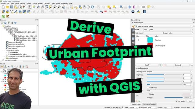
Derive Urban Footprint with QGIS