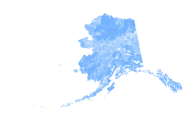
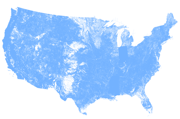
US CONUS Rivers Of Dimension By Annual Flow – An Older (2013) But Still SO Useful Hydrologic Visualisation
--
https://pacinst.org/american-rivers-a-graphic/ <-- shared technical post
--
“... Several things stand out:
1) the massive flow of the mighty Mississippi and Columbia River systems
2) the paucity of major rivers in the western US, especially the southwestern US, where the only major rivers are the seriously over-tapped Colorado and Rio Grande Rivers
3) the local importance of the Sacramento-San Joaquin Rivers in California, which serve the state’s cities and agricultural regions…”
#visualisation #infographic #water #hydrographic #hydrology #US #USA #CONUS #flow #humanimpacts #gage #USGS #USGSgage #agriculture #transportation #rivers #waterresources #overuse #monitoring #planning #AmericanRivers #mapping #spatial #spatialanalysis #scale #symbology #proportional #symbology #bigriver #Colorado #Columbia #Mississippi #SanJoaquin #RioGrande #NHD #NationalHydrographyDataset
#PacificInstitute | #USGS | #AmericanRivers
Nice To Be 'Back In The Data Trenches' Directly
--
https://www.usgs.gov/3d-hydrography-program <-- shared U.S. Geological Survey (USGS) #3DHP home page
--
I don't get to be here that often (and that is OK, #ILikeMyJob) - but it is nice to be back working directly with some individual spatial datasets - be it in #QGIS, #ArcGISPro, #PostgreSQL / #PostGIS or wherever...
#GIS #spatial #mapping #water #dataquality #water #hydrography #3DHP #NHD #opendata #USA #MI #reservoirs #dams #pluvial #fluvial #usecase #SQL
The Western Texas, etc hydrography/physiography especially - as recorded in NHD-sourced data - is always fascinating...
#hydrography #NHD #3DHP #geomorphology #USA #physiography #flowlines #opendata #bluelines #hydrology #USGS
I Am Proud To Be Part Of The Integrated Team Generating and Publishing An Open Data 3DHP Hydrology Spatial Data Product For The Nation At The USGS
--
https://doi.org/10.5066/P148NT7B <-- shared product DOI
--
https://commons.datacite.org/doi.org?query=10.5066%2FP148NT7B <-- shared DateCite repository record
--
https://3dhp.nationalmap.gov/ <-- 3DHP data is also available via a USGS spatial data service (with select & export capability)
--
[‘my’ first product DOI generation & publication as well ~smile~]
#GIS #spatial #mapping #data #water #hydrology #LiDAR #EDH #elevationderivedhydrography #3DHP #opendata #publicdata #DOI #stagedproducts #3DTNM #3DEP #NHD #national #USA #nonproprietary #waterresources #spatialanalysis #model #modeling #3d #vector #schema #DOI#geopackage #filegeodatabase #metadata #XML
@USGS
3D Hydrography Program (3DHP) 2024 Staged Product (FY25 Release) - ScienceBase-Catalog

This product is new in federal fiscal year 2025 (FY25), and consists only of vector data in a series of feature classes. The product represents the 3DHP dataset and the schema in which it is contained as of September 30, 2024 Future Annual Staged Product releases will reflect the schema at the time the product is generated and include more EDH-sourced data holdings.

Microsoft Virtual Events Powered by Teams

Microsoft Virtual Events Powered by Teams

WaterwayMap utilizes the directional data of waterways recorded in OpenStreetMap (OSM)…ordered lists of nodes that indicate the sequence and direction of flow…calculates additional hydrological details to provide a comprehensive visualization…

#NHD has had this for decades and more….

https://googlemapsmania.blogspot.com/2024/12/the-waterwaymap.html

The WaterwayMap

Maps Mania is a blog dedicated to tracking the very best digital interactive maps on the internet and the tools used to create them.

A more accurate charting of the full extent of stream networks will help land managers better protect U.S. creeks and rivers. #NHD always willing to improve! #EOS
https://eos.org/articles/mobile-bay-has-more-branching-brooks-than-shown-on-federal-maps
Mobile Bay Has More Branching Brooks Than Shown on Federal Maps

A more accurate charting of the full extent of stream networks will help land managers better protect U.S. creeks and rivers.

Eos