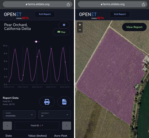
From Space To Field - Putting satellite insights into growers’ hands [OpenET]
--
https://irrigationtoday.org/features/from-space-to-field/ <-- shared technical media article
--
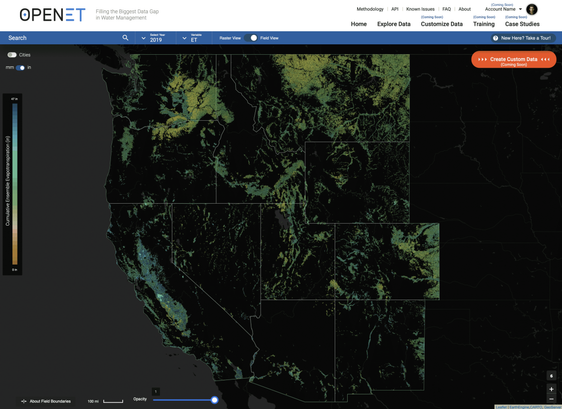
https://etdata.org/ <-- shared OpenET home page
--
https://www.nasa.gov/image-article/openet-satellite-based-water-data-resource/ <-- shared NASA technical article
--
https://youtu.be/Rbobf6aurLs?si=Q0kN9eiZH0gT8O5m <-- shared OpenET overview video
--
#OpenET #openscience #opendata #publicgood #publicservice #nonprofit #fedscience #fedservice #evapotranspiration #ET #Landsat #OLI #OperationalLandImager #groundwater #water #hydrology #spatialanalysis #spatiotemporal #agriculture #USA #farming #waterresources #watermanagement #planning #watersecurity #satellite #remotesensing #earthobservation #model #modeling #irrigation #metrology #raster #cost #economics #efficiency #foodproduction #mobileapp #FARMS #view #download #usecase #reporting
#OpenET #USGS #USDA @NASA #USGS_EROS
--
https://irrigationtoday.org/features/from-space-to-field/ <-- shared technical media article
--
https://etdata.org/ <-- shared OpenET home page
--
https://www.nasa.gov/image-article/openet-satellite-based-water-data-resource/ <-- shared NASA technical article
--
https://youtu.be/Rbobf6aurLs?si=Q0kN9eiZH0gT8O5m <-- shared OpenET overview video
--
#OpenET #openscience #opendata #publicgood #publicservice #nonprofit #fedscience #fedservice #evapotranspiration #ET #Landsat #OLI #OperationalLandImager #groundwater #water #hydrology #spatialanalysis #spatiotemporal #agriculture #USA #farming #waterresources #watermanagement #planning #watersecurity #satellite #remotesensing #earthobservation #model #modeling #irrigation #metrology #raster #cost #economics #efficiency #foodproduction #mobileapp #FARMS #view #download #usecase #reporting
#OpenET #USGS #USDA @NASA #USGS_EROS