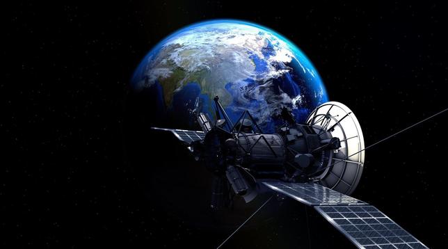
Using a Scientific Satellite for Passive Radar
Using a Scientific Satellite for Passive Radar https://hackaday.com/2026/03/30/using-a-scientific-satellite-for-passive-radar/
#RadioHacks #Antenna #Gpsantenna #Lband #Passiveradar #Radar #Sdr
#RadioHacks #Antenna #Gpsantenna #Lband #Passiveradar #Radar #Sdr
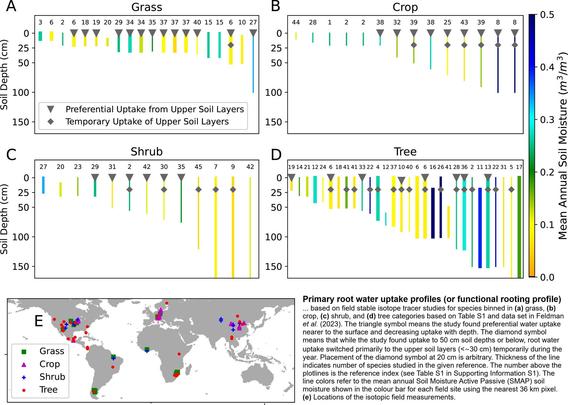
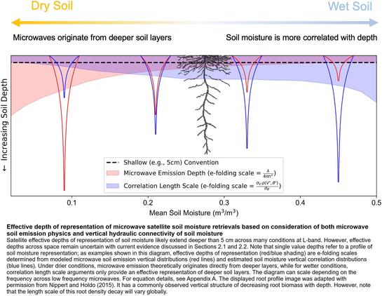
Remotely Sensed Soil Moisture Can Capture Dynamics Relevant To Plant Water Uptake
--
https://doi.org/10.1029/2022WR033814 <-- shared (2023) paper
--
#GIS #spatial #mapping #remotesensing #global #soil #moisture #earthobservation #Lband #satellite #landsurface #landuse #biosphere #hydrosphere #microwave #vegetation #botany #roots #agriculture #pluvial #rainfall #taproot #planthealth #foodsecurity #production #rootzones #spatialanalysis #spatiotemporal #grasslands #croplands #shrubs #trees #seasonal #water #hydrology #wateruptake #SMAP
@nasa @nasa Goddard @AGU
--
https://doi.org/10.1029/2022WR033814 <-- shared (2023) paper
--
#GIS #spatial #mapping #remotesensing #global #soil #moisture #earthobservation #Lband #satellite #landsurface #landuse #biosphere #hydrosphere #microwave #vegetation #botany #roots #agriculture #pluvial #rainfall #taproot #planthealth #foodsecurity #production #rootzones #spatialanalysis #spatiotemporal #grasslands #croplands #shrubs #trees #seasonal #water #hydrology #wateruptake #SMAP
@nasa @nasa Goddard @AGU

#ESA:
"
ESA’s HydroGNSS mission launched to ‘scout’ for water
"
".. was launched today, 28 November, marking a significant step in advancing global understanding of water availability and the effects of climate change on Earth’s water cycle."
28.11.2025
#biomass #ClimateChange #EO #Erdbeobachtung #Falcon9 #GNSS #HydroGNSS #Klimawandel #LBand #moisture #Raumfahrt #Satelliten #SpaceFlight #SpaceX #SSTL #Water

ESA’s HydroGNSS mission launched to ‘scout’ for water
The European Space Agency’s first Scout mission, HydroGNSS, was launched today, 28 November, marking a significant step in advancing global understanding of water availability and the effects of climate change on Earth’s water cycle.The two twin HydroGNSS satellites were carried into orbit at 19:44 CET aboard a SpaceX Falcon 9 rocket, as part of the Transporter-15 rideshare flight from the Vandenberg Space Force Base in California.
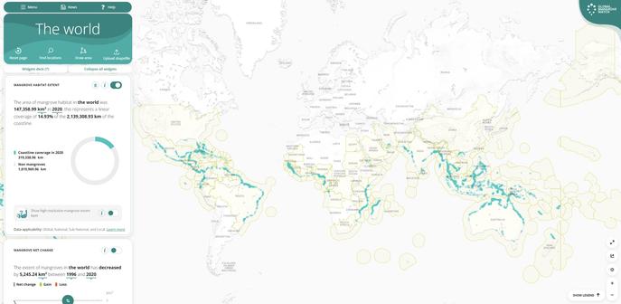
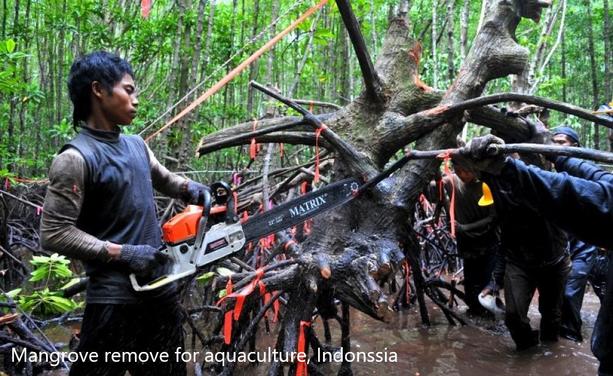
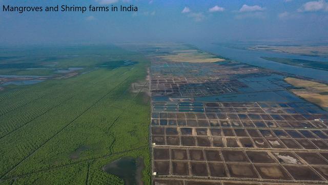
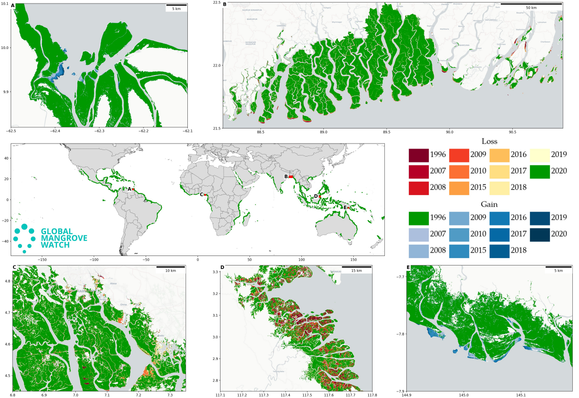
Global Mangrove Watch [remote sensing]
--
https://www.globalmangrovewatch.org/ <-- shared Global Mangrove Watch webmap/data page
--
https://www.mangrovealliance.org/ <-- shared Global Mangrove Alliance
--
https://doi.org/10.3390/rs14153657 <-- shared paper
--
https://doi.org/10.1016/j.landusepol.2016.03.010 <-- shared paper
--
#GIS #remotesensing #landsat #mapping #spatial #RSGISLIB #mangrove #change #extent #GlobalMangroveWatch #GMW #Lband #SAR #changedetection #satellite #imagery #map #global #spatialanalysis #spatiotemporal #protection #restoration #policymakers #opendata #model #modeling #algorithm #ecosystem #coast #coastal #fisheries #habitat #deforestation #environment #SAR #radar #JAXA #GlobalMangroveAlliance #conservation #risk #hazard #erosion #climatechange #planning #extremeweather
--
https://www.globalmangrovewatch.org/ <-- shared Global Mangrove Watch webmap/data page
--
https://www.mangrovealliance.org/ <-- shared Global Mangrove Alliance
--
https://doi.org/10.3390/rs14153657 <-- shared paper
--
https://doi.org/10.1016/j.landusepol.2016.03.010 <-- shared paper
--
#GIS #remotesensing #landsat #mapping #spatial #RSGISLIB #mangrove #change #extent #GlobalMangroveWatch #GMW #Lband #SAR #changedetection #satellite #imagery #map #global #spatialanalysis #spatiotemporal #protection #restoration #policymakers #opendata #model #modeling #algorithm #ecosystem #coast #coastal #fisheries #habitat #deforestation #environment #SAR #radar #JAXA #GlobalMangroveAlliance #conservation #risk #hazard #erosion #climatechange #planning #extremeweather
An old project I have not touched since I marked it.
So it was passed on to others.
I have been working on and off for a few weeks now filtering #LBand #ACARS messages for any that contain flight plans (#FPN) and then using #javascript to clean them up and convert them into #SkyVector URLs.
Getting better results and its getting amazing!
Classic example this week....
We got this FPN via our bot, then about 1/2 hour latter the aircraft took off and few the exact plan.
We are (for some flights) getting to the point of not just tracking/following, but KNOWING!
Getting better results and its getting amazing!
Classic example this week....
We got this FPN via our bot, then about 1/2 hour latter the aircraft took off and few the exact plan.
We are (for some flights) getting to the point of not just tracking/following, but KNOWING!
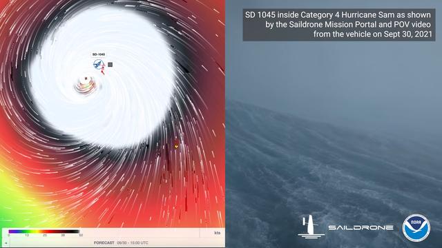
How Does A Sail Drone Bring Home Hurricane Footage In Record Time?
It is unlikely that as a young lad [Richard Jenkins] would had have visions of sailing into the eye of a Category-4 hurricane. Yet that's exactly what he's done with the Explorer 1045, an uncrewed sailing vehicle built by his company, Saildrone. If that weren't enough, footage from the vessel enduring greater than 120 MPH (almost 200 km/h) winds and 50 foot (15 M) waves was posted online the very next day, and you can see it below the break. We're going to take a quick look at just two of the technologies that made this possible: Advanced sails and satellite communication. Both are visible on Explorer 1045's sibling 1048 as seen below:
Saildrone Explorer 1048, a sibling of Explorer 1045, each one of five vessels equipped with a "hurricane wing"
The most prominent feature of course is the lack of a traditional sail. You see, from 1999-2009, [Richard Jenkins] was focused on setting the land world speed record for a wind powered vehicle. He set that record at 126.1 mph by maturing existing sail wing technology. [Richard] did away with conventional rigging and added a boom with a control surface on it, much like the fuselage and empennage of a sailplane.
Instead of adjusting rigging, the control surface could be utilized to fly the wing into its optimal position while using very little energy. [Richard] has been able to apply this technology at his company, Saildrone. The 23 foot Explorer vessel and its big brothers are the result.
How is it that the world was treated to the view from inside the eye of a hurricane only a day after the video was recorded? If you look at the stern of the vessel, you can see a domed white cylinder. It is a satellite communication base station called the Thales VesseLINK. Thales is one of the partner companies that built the satellites for the Iridium NEXT fleet, which has 66 operational satellites in Low Earth Orbit. The Iridium Certus service uses its L-Band (1.6ghz) signal to provide up to 352 kbps of upload speed and 704 kbps down. While not blazing fast, the service is available anywhere in the world and is reliable because it is not prone to rain fade and other weather based interference.
With just these two recent innovations, the Explorer 1045 was able to sail to the eye of a hurricane, record footage and gather data, and then ship it home just hours later. And we're hardly exploring the tip of the iceberg. More than just sailboat based cameras, these scientific instruments are designed to survive some of the harshest environments on the planet for over a year at a time. They are a marvel of applied engineering, and we're positive that there are some brilliant hacks hiding under that bright orange exterior.
If uncrewed sailing vessels float your boat, you might also enjoy this autonomous solar powered tugboat, or that time a submarine ran out of fuel and sailed home on bed sheets.
#dronehacks #news #transportationhacks #autonomoussaiboat #hurricane #iridiumnext #lband #leo #sailwing #satellitecommunication #weatherforecast