Flood Hydrology Roadmap [UK]
--
https://www.gov.uk/flood-and-coastal-erosion-risk-management-research-reports/flood-hydrology-roadmap <-- shared technical details
--
https://assets.publishing.service.gov.uk/media/62335ac2e90e070a54e18185/FRS18196_Flood_hydrology_roadmap_-_report.pdf <-- shared roadmap as a PDF
--
https://doi.org/10.2166/nh.2022.053 <-- shared paper
--
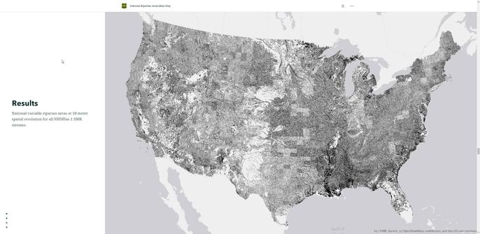
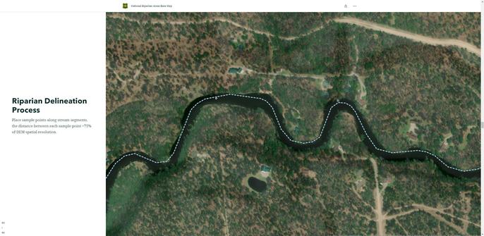
#water #hydrology #flood flooding risk hazard roadmap UK Britain cost #economics #publicsafety #publichealth #extremeweather #government #program #policy #mitigation #fluvial #floodhydrology #actionplan #England #Wales #Scotland #NorthernIreland #engineering #fluvial #pluvial #sewers #groundwater #reservoir #research #logistics #methods #operations #data #spatial #GIS #mapping #management #partnership #collaboration #regulations #interagency #riskmanagement #riskanalysis #practice #design #systems #landuse #change #climatechange
--
https://www.gov.uk/flood-and-coastal-erosion-risk-management-research-reports/flood-hydrology-roadmap <-- shared technical details
--
https://assets.publishing.service.gov.uk/media/62335ac2e90e070a54e18185/FRS18196_Flood_hydrology_roadmap_-_report.pdf <-- shared roadmap as a PDF
--
https://doi.org/10.2166/nh.2022.053 <-- shared paper
--
#water #hydrology #flood flooding risk hazard roadmap UK Britain cost #economics #publicsafety #publichealth #extremeweather #government #program #policy #mitigation #fluvial #floodhydrology #actionplan #England #Wales #Scotland #NorthernIreland #engineering #fluvial #pluvial #sewers #groundwater #reservoir #research #logistics #methods #operations #data #spatial #GIS #mapping #management #partnership #collaboration #regulations #interagency #riskmanagement #riskanalysis #practice #design #systems #landuse #change #climatechange