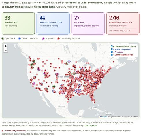
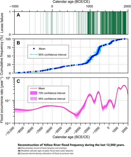
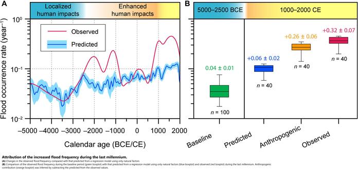
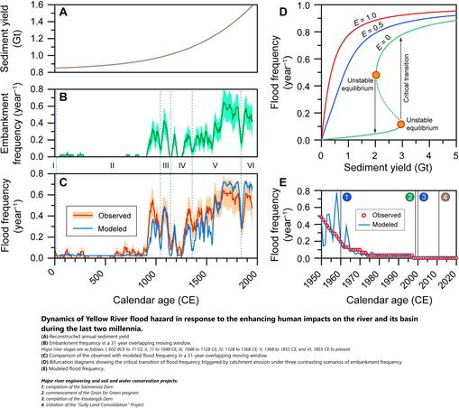
Erin Brockovich Asks Americans For Help As She Launches Data Center Map
--
https://www.newsweek.com/erin-brockovich-asks-americans-for-help-as-she-launches-data-center-map-11989813 <-- shared media article
--
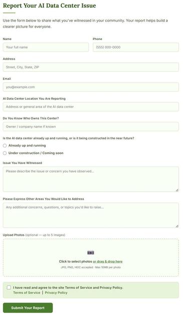
https://brockovichdatacenter.com/ <-- shared Brockovich AI Data Center Reporting web site
--
https://youtu.be/fp5ozQraKf4?si=7qu3g77iVVD3GGFJ <-- shared media video, @cbs Sunday Morning, “Nationwide boom in AI data centers stirs resistance”
--
#GIS #spatial #mapping #USA #nation #AI #datacenters #waterresources #utilities #energyconsumption #water #hydrology #hydrography #watermanagement #community #humanimpacts #costs #economics #ewaste #noise #risk #hazard #electricity #localcommunities #taxbreaks #cooling #energy #highenergyusage #infrastructure #landuse #environment #ecology #public #skepticism #environmentalimpact #scalability #growth #Virginia #Utah #Texas #Ohio #Arizona #Georgia
#ErinBrockovichFoundation #ErinBrockovich
--
https://www.newsweek.com/erin-brockovich-asks-americans-for-help-as-she-launches-data-center-map-11989813 <-- shared media article
--
https://brockovichdatacenter.com/ <-- shared Brockovich AI Data Center Reporting web site
--
https://youtu.be/fp5ozQraKf4?si=7qu3g77iVVD3GGFJ <-- shared media video, @cbs Sunday Morning, “Nationwide boom in AI data centers stirs resistance”
--
#GIS #spatial #mapping #USA #nation #AI #datacenters #waterresources #utilities #energyconsumption #water #hydrology #hydrography #watermanagement #community #humanimpacts #costs #economics #ewaste #noise #risk #hazard #electricity #localcommunities #taxbreaks #cooling #energy #highenergyusage #infrastructure #landuse #environment #ecology #public #skepticism #environmentalimpact #scalability #growth #Virginia #Utah #Texas #Ohio #Arizona #Georgia
#ErinBrockovichFoundation #ErinBrockovich