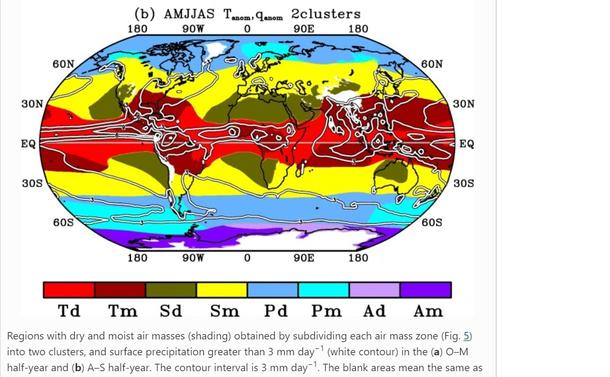
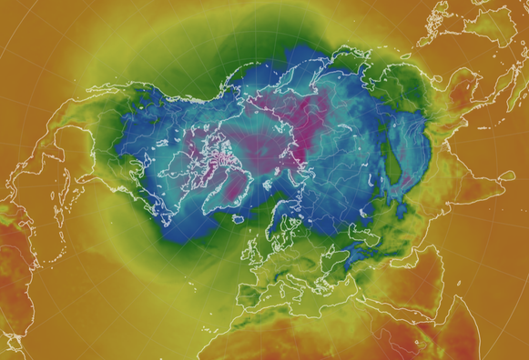
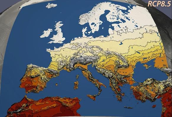
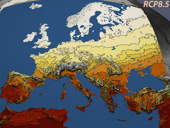
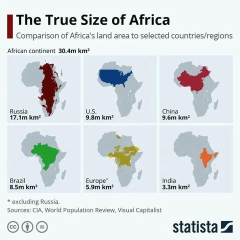
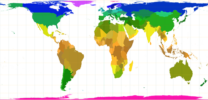
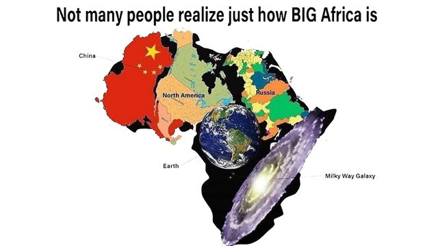
anatole

@anatole@mapstodon.space
80 Followers
29 Following
99 Posts
Follow this account for maps of climates or of populations
Africa is BIG
For the first time, I have managed to update all eleven of my country #train diagrams for the same year! And it's only May!๐Ÿ˜Š Represented are: ๐Ÿ‡ฆ๐Ÿ‡น๐Ÿ‡ง๐Ÿ‡ช๐Ÿ‡ฉ๐Ÿ‡ฐ๐Ÿ‡ซ๐Ÿ‡ฎ๐Ÿ‡ซ๐Ÿ‡ท๐Ÿ‡ฉ๐Ÿ‡ช๐Ÿ‡ฑ๐Ÿ‡บ๐Ÿ‡ณ๐Ÿ‡ฑ๐Ÿ‡ณ๐Ÿ‡ด๐Ÿ‡ธ๐Ÿ‡ช๐Ÿ‡จ๐Ÿ‡ญ
I started making the diagrams because I missed the (useful) official ones and wanted a planning guide for my travels. I hope they help you too when travelling through central or northern ๐Ÿ‡ช๐Ÿ‡บ #Europe (or whatever you need them for)!
๐Ÿ‘‰ You find the 2025 train diagrams on my blog: https://larstransportmaps.com/
lars' transport maps

unofficial public transport maps

lars' transport maps

Jet streams are fast flowing, narrow air currents. The main jet streams flow west to east around the globe.

Because of #climate collapse, the northern polar jet stream becomes more variable. A stratospheric polar vortex disruption is linked with extreme cold winter weather across parts of Asia and North America, including the Feb. 2021 North American cold wave. Report: https://www.bbc.com/news/science-environment-58425526

Anyway, #AMOC (the main ocean current system in the Atlantic Ocean) currently offers 12ยฐC to Ireland:

Climate change: Arctic warming linked to colder winters

A new study connects the heating of the Arctic region to extreme winter weather in the US.

Regional Climate Projections for Europe

Global climate change has different regional impacts; its effects are already noticeable today. Mankind will need to adapt to those future changes. To investigate possible regional climate changes in Europe in the 21. Century and to develop adaption strategies, regional climate simulations are performed. The Climate Service Center Germany (GERICS) is involved in the development of various models and methods to provide local climate change information. The simulated model results are stored at the DKRZ and can be downloaded from there through the ESGF (esgf-data.dkrz.de). DKRZ and GERICS have jointly produced animated visualizations showing the projected key changes in temperature and precipitation for Europe during the 21. Century.

DKRZ

@food @ecology ๐Ÿงต

#Cattle husbandry emits #greenhouse gas.
For example:
* South America and the Indian subcontinent breed most bovines who emit most methane.
* China and the Middle East produce too much livestock methane in regard to their bovine headcounts.

Emissions of #methane from livestock digestion per world region:

#Livestock #GreenHouseForcing #emissions #beef #bovines #dairy #GHG #climateChange #FAO #Copernicus #CH4 #climateBreakdown #China #India #Pakistan #MiddleEast #footprint

It is a joy to discover remote paths with nobody on sight.
No data plan with @organicmaps
I download the regional map in advance over Wifi and then use no cell communication.

#hiking #Triรจves #Vercors #Isรจre #Highlands #Loch #Scotland #walk #photography #landscapePhotography #OrganicMaps #openstreetmap #20YearsOfOSM #landscape #SilentSunday

6/ Many people know about the linguistic situation in Catalonia. Itโ€™s one of the purest linguistic examples of diglossia (two dialects or languages are used simultaneously by one community), but there are actually three officially recognised languages in Catalonia.

Catalan, Spanish and Aranese.

Aranese is a dialect of Occitan spoken in the Val dโ€™Aran. It has protected official status, and it is the only area of Occitania where the language is protected.

https://en.wikipedia.org/wiki/Aranese_dialect

#geoweirdness

Aranese dialect - Wikipedia

In tropical forests, the most vital function of protected areas is limiting roads and road-related environmental disruption.

Engert, J.E., Campbell, M.J., Cinner, J.E. et al.
"Ghost roads and the destruction of Asia-Pacific tropical forests". Nature (2024). https://doi.org/10.1038/s41586-024-07303-5

#roads #protection #CarbonSinks #forests #biodiversity #development #ecology #environment #impact #anthropocene #tropics #rainforests #logging #mapping #indonesia #Sumatra #Borneo #NewGuinea #PNG

ร—
Africa is BIG
@infobeautiful I know Asia is bigger, but *how much* bigger? The way Russia fits in with so much space left over makes me think it's not that much bigger.
@pdcawley @infobeautiful Asia is 44m km2, which makes sense as the two largest countries there, Russia and China together are about 22.6m km2 and you can see on the diagram above how much of Africa they would fill.
@pdcawley The size of Asia is 44,6 k km2.

@electricfusionQ @pdcawley
I was fundamentally unhappy with your choice of units.
So I thought about it for a second.
Surprisingly, you are wrong.
Asia is not 44,6 k km2, that would be only 0,04Mmยฒ

Asia is 44.6M kmยฒ, or, put straight, 44.6Mmยฒ
You're welcome ๐Ÿค—

@blausand

> Asia is not 44,6 k km2, that would be only 0,04Mmยฒ

no it would be 44.6 Mmยฒ

> Asia is 44.6M kmยฒ

no, that is a thousand times to big.

> or, put straight, 44.6Mmยฒ

yes correct.

https://www.wolframalpha.com/input?i=44614500+km%C2%B2+in+Mm%C2%B2

@electricfusionQ @pdcawley

Planck constant / Planck time - Wolfram|Alpha

Wolfram|Alpha brings expert-level knowledge and capabilities to the broadest possible range of peopleโ€”spanning all professions and education levels.

@deusfigendi @electricfusionQ @pdcawley
We definitely should start using this unit on a more regular base ๐Ÿคฃ

@blausand
By the way, that makes Asia bigger than the surface of the moon (38Mmยฒ)

To use the unit more regular: how many squaremegameters should a lunar property be? ๐Ÿ˜„
@electricfusionQ @pdcawley

@infobeautiful As a Canadian, I apologize for Canada not being included in the imagery.
@reay Why yes, let's use the #1, 3, 4 and 5th largest countries, because fuck Canada in particular. Also China has more land area than the US.
@infobeautiful
@alessandro @reay @infobeautiful Perhaps Canada doesn't take more space in discourse than it takes on a map.
@alessandro @infobeautiful I had kinda taken it as a Super Powers Being Featured-type thing, but the choices beyond that do seem a bit random, other than India (still the largest population?)

@alessandro @reay @infobeautiful

They're doing total area, not total land so
China: 9,596,961 km2
US: 9,833,520 km2
Canada: 9,984,670 km2

I'm also assuming they're were going for biggest size & population density which drops Canada off the list.

@infobeautiful The depicted part of the US is less than 8.1M kmยฒ, i.e. should look smaller than Brazil. If you want to mention its full size you must show Alaska, itโ€™s too big to be treated as a detail!

@infobeautiful

This is interesting, but also not an accurate comparison. Using all of North America would be a more appropriate comparison than just the lower 48 states of the US. (Cutting out Alaska removes 17% of US landmass.)

@Ehay2k @infobeautiful

The size they're quoting does include Alaska.

@deirdrebeth @infobeautiful

Ok. The image they use does not, so that's a bit misleading.

@infobeautiful A statistics outfit stacking units. And the wrong ones to boot. Tsk tsk โ€ฆ SMH.

Itโ€™s not 30.4 milli kilometers squared. Itโ€™s 30.4*10^6*(10^3)^2 m^2 = 30.4*10^12 m^2 =30.4 Tm^2. Yeah, thatโ€™s big.

@ArtHarg @infobeautiful yes, they're wrong, but you're wrong too, and you're not even wrong in a self-consistent way
@infobeautiful รfrica is not a country.

@aurochs @infobeautiful

They never said it was, and FAR too many people look at the Mercator map and think their country is bigger than that entire continent.

@deirdrebeth @infobeautiful You are not wrong. On the other hand, the people who do not understand the distortion of the mercator projection may need to be reminded of that.

@aurochs @deirdrebeth @infobeautiful

I heard there's an African Union. Is it similar in concept to the EU?

@Phosphenes @deirdrebeth @infobeautiful I don't think it is. Although there definitely is a pan-african movement.
I have doubts about the accuracy of the shape of Russia, though. It curves more around the north pole.
@infobeautiful I didn't realize Brazil was so big and India so small
@mrpistachios @infobeautiful Brazil and India are two pieces of Africa that broke off and wandered away.
@infobeautiful Yes, Africa is big. The Mercatur projection artificially belittles it relative to the more poleward continents.

@infobeautiful ๐Ÿ‘ AFRICA ๐Ÿ‘ IS ๐Ÿ‘ NOT ๐Ÿ‘ A ๐Ÿ‘ COUNTRY. ๐Ÿ‘ IT'S ๐Ÿ‘ A ๐Ÿ‘ CONTINENT!

Continents are big. Africa is a little bigger than North America. But it would be super dandy for people to stop erasing African countries, eh?

@renwillis @infobeautiful no one said it is a country.

@atoa @infobeautiful my friend, look at the graphics.

This is an old meme now. Comparing ALL of Africa to random countries to show how big Africa is. That's like showing how big a state is by comparing it to cities. It's the western lens that treats Africa as a country, erasing the multitudes of cultures and diverse countries within Africa.

@renwillis @atoa @infobeautiful ๐Ÿ‘ EUROPE ๐Ÿ‘ IS ๐Ÿ‘ NOT ๐Ÿ‘ A ๐Ÿ‘ COUNTRY. ๐Ÿ‘ IT'S ๐Ÿ‘ A ๐Ÿ‘ small part of the Eurasian landmass, etc
@infobeautiful The first time I saw this it absolutely blew my mind. ๐Ÿคฏ
@infobeautiful The problem is that Africa and South America looks smaller as countries nearer to the poles are stretched. Here an equal area map, where Greenland has te size of Saoudi Arabia and not 3 times bigger on regular maps:
@infobeautiful I found the sizes of Brazil and India surprising.

@infobeautiful
Would you PLEASE refrain to use a small m for million? It is wrong, and there's no reason to not use the correct capital M.
Also, there's no such thing as stacking of unit prefixes, and you know that. It is also just plain WROONG. OMG I'm rising tone.

Please, if you need to dive into matters of huge areas, dare to make use of Mmยฒ, which is a square a million meters long and a million meters wide.

It IS, in fact, as simple as that.
Thank you.

@infobeautiful
OMG see I even had to educate chatGPT on this one ๐Ÿคฃ
https://chatgpt.com/share/682e1be1-b0f8-8011-8301-4302b1b7d9f2
ChatGPT - ่กŒๆ”ฟๆ›ธๅฃซ่ฌ›ๅบงๆฏ”่ผƒ

Shared via ChatGPT

ChatGPT
@infobeautiful been asked, oh youโ€™re originally from Cape Town. Do you know my friend in Nairobi? ๐Ÿ˜‚

@infobeautiful i mean, yes, it's big, but that is comparing a continent to countries (well, except for europe). it's a little misleading. the size listed for europe seems wrong, too (europe is 10m sq km).

if you compare africa to other continents like asia, north america, or south america the differences are less stark.

@infobeautiful

Years ago, I saw a meme one of these where they said Africa was mind bogglingly big, and they put all the other continents inside Africa, including Africa.

@infobeautiful

There's a Know Your Meme page about it, but I don't see the exact one that I saw before.

https://knowyourmeme.com/memes/relative-map-sizes-how-big-africa-really-is

Relative Map Sizes / How Big Africa Really Is | Know Your Meme

Relative Map Sizes, best known for the How Big Africa Really Is and How Big Texas Really Is versions, are a series of memes parodying infographics that sho

Know Your Meme
@infobeautiful
Africa is a fucking CONTINENT.
@infobeautiful @reiayanami it is truly hard to imagine; that said, is that the size of the US with, or without Alaska?

@infobeautiful @reiayanami Doing my own โ€œhomeworkโ€ ๐Ÿ˜

9.8M km^2 is the size with Alaska (which is 1.7M km^2 itself) included, but the graphic shows it without, which would be why it doesn't seem to be accurate in its relative size.

Relative size of Australia would have been interesting too (7.6M km^2).

@infobeautiful Who learned to recite landmasses by importance?
Europe, Asia, North America, South America, Australia. Why don't I remember Africa as part of that? At some time, it must have been added, along with Antarctica.

@infobeautiful me, owning a globus used for lighting my reeding corner:

"This is news?"