🚴‍♂️🔍🥱 So apparently, everyone was losing sleep over the "vital" need for more precise #elevation #data in GraphHopper's routing engine. Because, clearly, your #cycling route simply isn't complete without knowing that hill is exactly 2.34567 meters high. 🌍🚫
https://www.graphhopper.com/blog/2026/03/23/more-precise-elevation-data-for-graphhopper/ #GraphHopper #SleepDeprivation #PrecisionRouting #TechHumor #HackerNews #ngated
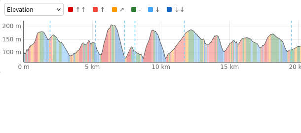
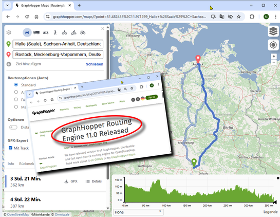
More Precise Elevation Data - GraphHopper Directions API

GraphHopper is used for many use cases and various companies around the globe have integrated it to provide outdoor trip planning for their customers. They all rely on precise elevation data: be it for displaying purposes, statistics regarding the incline, for bike routing to avoid hills or to better estimate energy usage of electric vehicles. […]

GraphHopper Directions API

#Carburoid: After adding route deviations, geodesic distance become a bad approximation. So current struggle is adding real road distance. I lost many hours getting #graphhopper working and yet no outcome. Default configurations don't work out of the box, data blobs are too big and features are too overshoot for what i need, just the distance. Documentation for offline use is obscure and #AI agents loop among non-working solutions. I am stuck. Any suggestions?

#opensource #kotlin #android

@nclick sehr gut. Vielen Dank. Werde ich testen. Ich habe schon einige alternative #naviapps getestet. Mit den bekannten wie #OsmAnd #GraphHopper #organicmaps bin ich nicht wirklich happy gewesen und habe bisher #MagicEarth für mich entdeckt. #CoMaps runtergeladen und installiert! Danke f Hinweis!

PS: Die #Sprachausgabe #TTS ist in meinem E/OS shitty. (Gibt es eine nette alternative TTS-Plastikdame in deutsch?)

#navigation #naviapp #did #didit #diday #digitalindependenceDay #eos #android

CoMaps - Hike, Bike, Drive Offline with Privacy | F-Droid - Free and Open Source Android App Repository

Easy map navigation - Discover more of your journey - Powered by the community

RE: https://social.notjustbikes.com/@notjustbikes/115984775951005911

Nessuno dovrebbe usare google maps per andare in bici: chi l'ha progettato non oncepisce che l'auto potrebbe non essere il modo migliore di spostarsi, specialmente in città.

Avete mai notato come sono rappresentate le strade pedonali nell'app? O che gli spostamenti includono il traffico, ma mai il tempo per trovare parcheggio e per poi andare dal parcheggio alla destinazione?

Tutto spiagato nel video di @notjustbikes , che potete trovare anche su YouTube: https://www.youtube.com/watch?v=csHdwHTteOw&pp=2Ab7Cg%3D%3D

(Per trovare il miglior percorso ciclabile potete provare https://graphhopper.com/maps/?profile=bike)

#graphhopper #googlemaps #motonormatività

@helenajambor
Ach ja: Während OsmAnd und @CoMaps offline arbeiten, gibt's auch noch eine App, die Internet-Zugang braucht: #graphhopper, am PC über https://graphhopper.com/maps.
GraphHopper Maps | Route Planner

Plan routes and get driving directions from GraphHopper Maps using open source and open data

I made GNOME Maps stop doing search queries faster than most people can type, with this One Weird Trick™: https://gitlab.gnome.org/GNOME/gnome-maps/-/merge_requests/584

Medium-to-fast typists will no longer see flickering search results and won't be doing "Hokuto no ken" network requests anymore. I presume #GNOME users will have less chances of collectively DDoSing servers when the Year of the Linux Desktop™ happens.

#GNOMEMaps #OpenStreetMap #GraphHopper #EnergyEfficiency #EnvironmentThisWeek

Increase search widgets' activation delay (!584) · Merge requests · GNOME / gnome-maps · GitLab

A more realistic default delay avoids spamming the UI, backend, servers. Benefits of this approach: Eliminates flickering in the search GUI at...

GitLab
Die Leute™: „Man kann keine Landkarten hören.“

Ich: „Doch.“

#OpenStreetMap #GraphHopper #Sauerland #Bilder hören
GraphHopper Maps | Route Planner

Plan routes and get driving directions from GraphHopper Maps using open source and open data