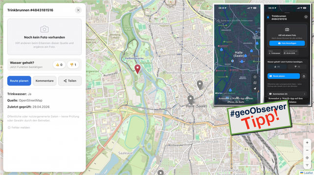
Weather Replay: Historisches Wetter ab 1940 visualisieren / Visualising historical weather data from 1940 onwards https://geoobserver.de/2026/05/21/weather-replay-historisches-wetter-ab-1940-visualisieren/ via @galeanodavid #gistribe #gischat #fossgis #foss4g #OSGeo #spatial #geospatial #DataViz #gis #geo #geoObserver pls RT

🔍 Question for the #Fediverse:
Do you know any #PeerTube instances or channels that publish videos about #opensource #GIS?

I’m looking to expand federation on my PeerTube instance #QwastTube and would love to follow more geospatial creators, universities, #OSGeo communities, or conference channels.
Suggestions are very welcome!

Volunteering for the campaign of #GLPvdA during the last municipal elections in Rotterdam inspired me to try a small pilot for planning and monitoring canvassing with #QGIS and @merginmaps.
In my new video, I show how to set up a similar workflow: simple, practical, and fully #opensource.

▶️Watch on QwastTube: https://videos.qwast-gis.com/w/je8KqK2BpNyNREiavxidYB

#GIS #OpenData #Canvassing #OSGeo #FOSS4G

Smart Canvassing with Mergin Maps

PeerTube
If anyone has common ERRORs they are running into with the new GDAL CLI tools please send on examples https://github.com/OSGeo/gdal/pull/14583 #gdal #osgeo
Doc: Add error codes doc with examples by geographika · Pull Request #14583 · OSGeo/gdal

This PR has been a work-in-progress for the last few months. I'm creating a draft PR to get feedback if this page would be a useful addition to the user docs. The idea is to list each of the GD...

GitHub

confused about #postgis ST_NPoints with polygons, because a triangle apparently has 4 points.

SELECT ST_NPoints(ST_GeomFromText('POLYGON ((0 0, 0 1, 1 0, 0 0 ))'));

From a technical point it makes sense, but it is also quite unintuitive, because normal people on the street would definitely say a triangle has 3 points ...

#gischat #gistribe #osgeo #foss4g