Study Highlights Growing Importance Of Multi-Day Storms In Future U.S. Flood Risk
--
https://news.okstate.edu/articles/engineering-architecture-technology/2026/study-highlights-growing-importance-of-multi-day-storms-in-future-u.s.-flood-risk <-- shared technical article
--
https://doi.org/10.1088/2752-5295/ae4f14 <-- shared paper
--
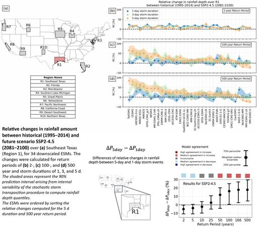
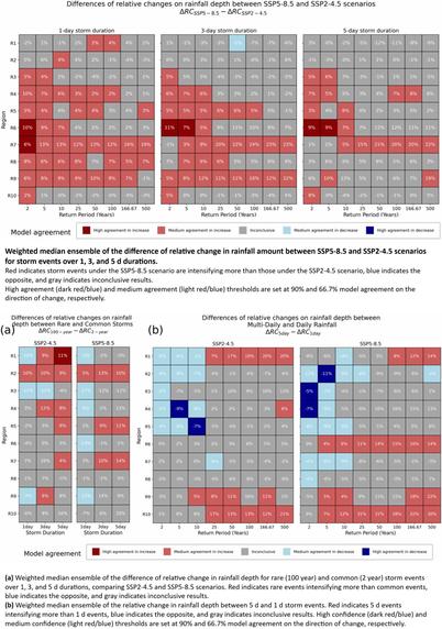
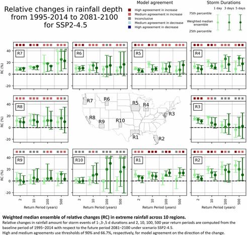
“Extreme rainfall is projected to intensify as the climate warms, yet whether the greatest increases will occur in multi-day or single-day events remains uncertain. This knowledge gap is particularly pressing given recent catastrophic floods triggered by multi-day rainfall events, prompting the question of whether multi-day events could, in fact, intensify more than their daily counterparts, and by how much. This study addresses this question using an ensemble of 34 downscaled Earth System Models under two Shared Socioeconomic Pathways (SSP2-4.5 and SSP5-8.5), focusing on changes in extreme rainfall by the end of the century across ten regions of the contiguous United States. [Their] statistical framework evaluates model agreement, ensemble-mean changes, and the significance of these changes for both daily and multi-day rainfall extremes. Results show that extreme rainfall amounts are expected to increase for most regions and durations. The degree of intensification, however, depends strongly on event rarity and regional climate characteristics. Notably, in the U.S. western Gulf Coast region, very rare multi-day events (e.g., 500 year return period) are projected to intensify more than their daily counterparts, a phenomenon that could be explained by increased stalling of tropical cyclones, which can prolong heavy rainfall over multiple days. These results challenge the assumption that daily extremes dominate future risk and highlight the need to consider event duration when updating flood-hazard maps, design standards, and adaptation planning…”
#Flooding #FloodRisk #FloodInsurance #FloodAwareness #Explore #FloodPreparedness #FlashFlooding #ClimateResilience #climatechange #extremeweather #DisasterPreparedness #StormwaterManagement #FloodSafety #CommunityResilience #risk #hazard #model #modeling #floodrisk #multiday #rainfall #precipitation #storm #water #hydrology #hydrography #planning #policy #regulations #climatemodel #CONUS #USA #publicsafety #cost #economics #damage #loss #infrastructure #spatiotemporal #spatialanalysis #earthsystemmodels #forecasting #meteorology #designstandards #floodmapping #mitigation #flood
--
https://news.okstate.edu/articles/engineering-architecture-technology/2026/study-highlights-growing-importance-of-multi-day-storms-in-future-u.s.-flood-risk <-- shared technical article
--
https://doi.org/10.1088/2752-5295/ae4f14 <-- shared paper
--
“Extreme rainfall is projected to intensify as the climate warms, yet whether the greatest increases will occur in multi-day or single-day events remains uncertain. This knowledge gap is particularly pressing given recent catastrophic floods triggered by multi-day rainfall events, prompting the question of whether multi-day events could, in fact, intensify more than their daily counterparts, and by how much. This study addresses this question using an ensemble of 34 downscaled Earth System Models under two Shared Socioeconomic Pathways (SSP2-4.5 and SSP5-8.5), focusing on changes in extreme rainfall by the end of the century across ten regions of the contiguous United States. [Their] statistical framework evaluates model agreement, ensemble-mean changes, and the significance of these changes for both daily and multi-day rainfall extremes. Results show that extreme rainfall amounts are expected to increase for most regions and durations. The degree of intensification, however, depends strongly on event rarity and regional climate characteristics. Notably, in the U.S. western Gulf Coast region, very rare multi-day events (e.g., 500 year return period) are projected to intensify more than their daily counterparts, a phenomenon that could be explained by increased stalling of tropical cyclones, which can prolong heavy rainfall over multiple days. These results challenge the assumption that daily extremes dominate future risk and highlight the need to consider event duration when updating flood-hazard maps, design standards, and adaptation planning…”
#Flooding #FloodRisk #FloodInsurance #FloodAwareness #Explore #FloodPreparedness #FlashFlooding #ClimateResilience #climatechange #extremeweather #DisasterPreparedness #StormwaterManagement #FloodSafety #CommunityResilience #risk #hazard #model #modeling #floodrisk #multiday #rainfall #precipitation #storm #water #hydrology #hydrography #planning #policy #regulations #climatemodel #CONUS #USA #publicsafety #cost #economics #damage #loss #infrastructure #spatiotemporal #spatialanalysis #earthsystemmodels #forecasting #meteorology #designstandards #floodmapping #mitigation #flood