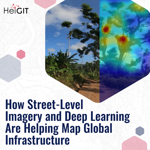
The potential applications of street-level imagery and deep learning methods are countless: reliable logistics, inclusive mobility, accessibility analysis.
But there are many challenges, too: How to easily collect new imagery? How to process the imagery in a free, flexible and safe way?

We wrote about our best practices and related projects on our blog: https://buff.ly/0VCrNj3

Does anyone here have best practices or innovative uses of #streetlevel images to share? What should we map next?

Out and about in Dublin City centre this morning. And it was good. #Dublin #Mastodaoine #StreetLevel

"On the Frontline of Global #Inequalities: A #Decolonial Approach to the Study of #StreetLevel #Bureaucracies"

is this month's #OpenAccess publication in the spotlight.

Read our interview with author Flávio Eiró on what changes he would advocate for in global #KnowledgeProduction to address inequality.
Does the open science movement sufficiently consider perspectives of the Global South?

https://www.rug.nl/library/open-access/blog/open-access-publication-in-the-spotlight-september-on-the-frontline-of-global-inequalities-a-d

#OpenScience #decolonization #GlobalSouth #sociology #anthropology

Open Access Publication in the Spotlight (November) - 'On the Frontline of Global Inequalities: A Decolonial Approach to the Study of Street-Level Bureaucracies'

University of Groningen

Mapilio is the easiest way to keep maps updated and more functional! 🌍
We have integrated with OpenStreetMap (OSM) Editor so you can update maps more easily and efficiently. 🚀
To keep maps more up to date, try mapilio.com now.🎉

#mapilio #openstreetmap #osm #map #mapping #travelphotography #data #citymap #imageprocessing #smartmap #streetlevel #streetlevelphotography #gopro #camera

As of today, active capturing from 43 countries 🎉🎉📸

Thank you to everyone who contributed

https://mapilio.com/app

#mapping #map #contribute #world #city #streetlevel #image #openstreetmap #mapilio #osm #imageprocessing

Mapilio | App

Create an account and log in to capture and make contributions for better maps.

#WilmasReview of the week

Wilma 🐶 as a #streetlevel #bureaucrat loves to #innovate. Read more about the role of #frontlineworkers in exploring, experiencing, and experimenting with new #policy instruments and how this relates to #walkability of cities in this #Public Management Review article by Anat #Gofen, Oliver D. #Meza Canales, and Carlos #Moreno Jaimes.

https://doi.org/10.1080/14719037.2023.2171095

#postdog #kontorhund #Ledelsescenter #AarhusUniversity

Frontline organizations as experimental settings for policy change: why public management matters even more

Termed here as Street-Level Policy Innovation, this study shifts attention to public managers’ role in policy change processes during which local street-level implementation adaptations are later f...

Taylor & Francis

Kennt ihr einen freien #OpenSource Dienst für #streetlevel #Bilder, die mit #Landkarten und Routen verknüpft sind?

Früher habe ich viele #Bilder meiner Fahrten mit dem #Fahrrad bei https://www.mapillary.com/app gespeichert, bis der Dienst von Facebook gekauft wurde.

Heute nutze ich manchmal https://kartaview.org/map

@fedibikes @mastobikes_de

Mapillary

Street-level imagery, powered by collaboration and computer vision.