HeiGIT

@heigit
722 Followers
111 Following
215 Posts
Open-source geoinformation, methods and software for the benefit of the environment and society.
---
This is the official account of HeiGIT (Heidelberg Institute for Geoinformation Technology) at Heidelberg University.
Check us out at https://heigit.org/

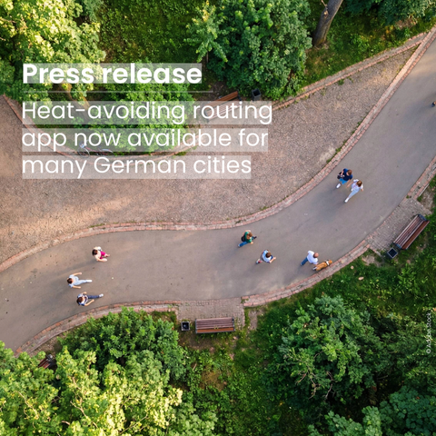
How is your city preparing for the summer heat?

We have built a heat-avoiding routing application available in 80 major German cities. It calculates pedestrian routes based on high-resolution shadow data, steering people away from sun-exposed roads.

We are actively looking for collaboration partners that want to co-develop it further based on their own data and needs.
๐Ÿ“ฉ [email protected]
๐Ÿ‘‰ https://heigit.org/heat-resilient-mobility-in-80-major-german-cities-and-an-invitation-to-shape-its-future/

#Klimaanpassung #SmartCity #Stadtplanung #UrbaneMobilitรคt #Hitze

How complete and reliable is #OpenStreetMap data in your region?

We are introducing country reports on the Humanitarian Data Exchange platform.

The new reports show #OSM #dataquality across a country & identify where important gaps remain. They provide insights on roads, buildings, currentness, and spatial distribution.

The reports are powered by the ohsome quality API & are also available as datasets in CSV & GPKG formats.

More topics are planned.

๐Ÿ‘‰ https://heigit.org/introducing-ohsome-quality-api-country-reports-for-openstreetmap-data-quality-on-the-humanitarian-data-exchange-platform/

#humanitarian

Another summer is approaching. And with it, the familiar detours through parks, the instinct to cross to the shaded side.

What if routing could account for heat?

Soon, we are releasing heat-avoiding routing for 80 major German cities that steers people through shaded corridors & away from sun-exposed roads.

We are looking for municipalities that want to co-develop the tool further & shape it to their local needs. Reach out: [email protected]

#SmartCity #OpenSource #Klimaanpassung

We have a new #OpenData tool to assess traffic emissions๐Ÿš—๐Ÿ’จ

๐˜›๐˜ณ๐˜ข๐˜ง๐˜ง๐˜ช๐˜ค ๐˜Œ๐˜ฎ๐˜ช๐˜ด๐˜ด๐˜ช๐˜ฐ๐˜ฏ๐˜ด is the latest addition to the Climate Action Navigator, our interactive dashboard to aid urban #ClimateAction.

It estimates transport emissions for all main roads in Germany. It shows which streets and districts are most impacted by traffic, and where policy changes (e. g. car-free areas) are most needed.

๐Ÿ“‘Read more: https://heigit.org/assessing-road-traffic-emissions-with-the-climate-action-navigator/
๐Ÿ“ŠTry it out and check your city: https://climate-action.heigit.org/

๐Ÿ—บ๏ธ ohsomeNow Stats got a major upgrade!

With ohsomeNow, you can now explore individual stats of #OpenStreetMap mappers.
Log in with your HeiGIT account to explore your contribution history with the same depth and flexibility already available for campaigns.

๐Ÿ”‘ A free HeiGIT account gives you access to our other tools: openrouteservice (ORS) and the Climate Action Navigator (CAN).

๐Ÿ“‘ Read more on our blog: https://heigit.org/new-user-statistics-in-ohsomenow/
๐Ÿ“Š Explore OSM stats with ohsomeNow: ohsome-now.heigit.org

๐Ÿšงservice announcement for #openrouteservice (ORS) users๐Ÿšง

As we are moving to a unified structure for all HeiGIT APIs, we are deprecating the URL https://api.openrouteservice.org. From now on, please use the new URL https://api.heigit.org.

(This is only a deprecation of the URL, not a deprecation of our services: openrouteservice remains accessible!)

More info on the openrouteservice forum: https://ask.openrouteservice.org/t/deprecating-api-openrouteservice-org-in-favour-of-api-heigit-org/7912

๐Ÿ—บ๏ธ Are you involved with academic research related to OpenStreetMap? Come and share it with us! ๐ŸŽ“

๐Ÿ“ฃ Call for OSM Science 2026 ๐Ÿ“ฃ

OSM Science 2026, aka the Academic Track of State of the Map, is now accepting submissions!

The 9th edition of OSM Science will be part of the State of the Map 2026 conference, taking place on August 28-30 in Paris (France), where a full day of in-person sessions will be dedicated to scientific research about, and with, OpenStreetMap.

๐Ÿฅณ Shout out to the members of the new governance team of #mapswipe :
Amar Shahi
Katherine Kinzer
Sam Colchester
Nicole Siggins
Maria Longley

The governance team, elected by the community for 1,5 year, sets priorities, documents community decisions and supports coordination efforts including communications and monthly meetings.

๐Ÿ—บ๐Ÿ“ฒMapSwipe is essential for narrowing down the area of the #MissingMaps projects to where people live. We are happy that @mapswipe is in good hands and thriving!

๐Ÿ—บ๏ธ๐— ๐—ฎ๐—ฝ ๐—ผ๐—ณ ๐˜๐—ต๐—ฒ ๐— ๐—ผ๐—ป๐˜๐—ต โ€“ ๐—ฆ๐—น๐—ผ๐—ฝ๐—ฒ ๐—ผ๐—ณ ๐—•๐—ถ๐—ธ๐—ฒ๐—ฎ๐—ฏ๐—น๐—ฒ ๐—ฃ๐—ฎ๐˜๐—ต๐˜€ ๐—ถ๐—ป ๐—ญ๐˜‚๐—ฟ๐—ถ๐—ฐ๐—ต, ๐—ฆ๐˜„๐—ถ๐˜๐˜‡๐—ฒ๐—ฟ๐—น๐—ฎ๐—ป๐—ฑ

Urban cycling depends also on the terrain. This map shows the slope of bike paths in Zurich, using #OpenStreetMap and elevation data. This shows where action might be needed to make urban mobility more inclusive and accessible.

More bikeability assessments on the Climate Action Navigator: https://climate-action.heigit.org/

#opendata #cycling #urbanmobility #climateaction

How can open-source routing tools support better waste collection in rapidly growing cities?

In Kenya, #openrouteservice (ORS) was used to improve planning for solid waste collection in underserved areas. APHRC organized #GIS trainings for environmental officers, introducing #QGIS, ORS, and Datawrapper.
Participants learned how to optimize waste collection routes, generate isochrone maps, & estimate travel times between collection points and disposal sites.

The project: https://heigit.org/optimizing-solid-waste-collection-in-underserved-regions-using-openrouteservice-a-pilot-study-in-kisumu-kenya/