#grid3 auch schön.
GridWords (🇬🇧 April 5, 2026) 3/6 in 0:25 🔥3
⬜⬜🟨🟨⬜
🟩🟩⬜🟨⬜
🟩🟩🟩🟩🟩
#grid3 auch schön.
GridWords (🇬🇧 April 5, 2026) 3/6 in 0:25 🔥3
⬜⬜🟨🟨⬜
🟩🟩⬜🟨⬜
🟩🟩🟩🟩🟩
Nettes Wort heute 🥰 #grid3
GridWords (21. März 2026) 3/6 in 0:22 🔥7
⬜⬜🟩⬜⬜
⬜🟩🟨⬜⬜
🟩🟩🟩🟩🟩
🚨 New WorldPop gridded age & sex-structured population estimates for #Uganda in 2022 + methodology available to download: wopr.worldpop.org/?UGA/Population/v2.0
The outputs were co-developed with #UNICEF Columbia University and #GRID3 Top-down disaggregation (www.worldpop.org/methods/populations/) of U.S. Census Bureau projections to 100x100m grid cells was undertaken.
🚨 New project: GRID3 2023-25 #Population estimation method development, high-resolution #mapping and training for #Nigeria #DRC and sub-Saharan #Africa
#ProgrammingR #Bayesian #Geospatial #GRID3 #GatesFoundation

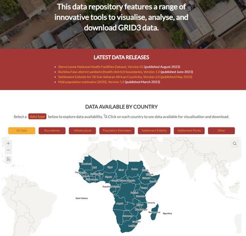
Current projects GRID3 2023-25 Learn More The fear of “here”: Integrating place-based travel behaviour and detection into novel infectious disease models Learn More Digital technologies to map zero-dose and unreached children in West and Central Africa (Reach the unreached) Learn More WorldPop Global Demographic Data Learn More Phase III of Countdown to 2030 Learn … Current projects Read More »
🚨 New data: Gridded population estimates for #Uganda

Le dénombrement de la population, dénominateur de nombreux indicateurs statistiques, est crucial pour les politiques publiques d’un pays. Il est du ressort des instituts nationaux de statistique d’en organiser la collecte, le plus souvent par le biais d’un recensement. Que se passe-t-il lorsqu’une partie du territoire n’est pas accessible aux agents recenseurs ? Actuellement, les données spatiales, telles qu’extraites de l’imagerie satellite, offrent une information géographique complète et de haute résolution, qui représente, lorsque combinée à un dénombrement partiel de la population, une opportunité sans précédent pour estimer les effectifs des territoires manquants. Leur précision spatiale rend également possible une estimation carroyée de la population en haute résolution, un format de données innovant à la croisée de la géographie et de la démographie. À partir du cas du Burkina Faso, cet article analyse comment le découpage du pays en carreaux de 100m sur 100m permet dans un premier temps de développer un modèle pour estimer, par le biais d’une approche hiérarchique bayésienne, la population des zones caractérisées par des problèmes sécuritaires n’ayant pas pu être dénombrées lors du dernier recensement de 2019. Ce découpage permet dans un second temps de désagréger les effectifs obtenus, par le biais d’un modèle d’apprentissage statistique pour obtenir une précision spatiale d’estimation de la population inégalée.