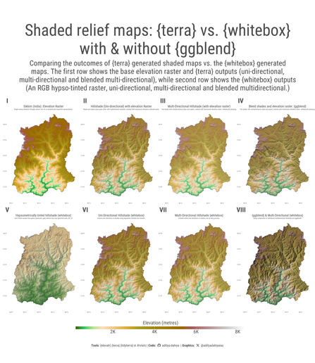
#dataviz #maps Comparing hill-shade maps in R using {terra} vs. {whitebox} - along with impressive effects of {ggblend}. Example code for Sikkim in #India.
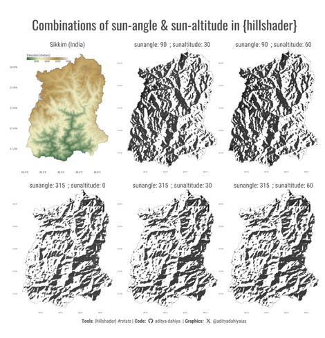
Data: #elevatr by US EPA
Full Code🔗https://tinyurl.com/maps-shaded
Tools: #rstats, #ggplot2, #ggblend by @mjskay , #whitebox by Qiusheng Wu
Showing elevation in Maps (2) : {whitebox} & {terra} – visage

#dataviz #maps Code experimenting with package {hillshader} by @pierreroudier - a wrapper around #rayshader - quick code to plot hilly regions in #rstats
Full Code🔗https://tinyurl.com/hill-sikkim
Tools: #ggplot2 #terra #tidyterra by @dhernangomez #elevatr by USEPA
Showing elevation in Maps (1) : {hillshader} – visage

Do you like to make maps like me or do you want to learn how to make them? I found some tutorials for those interested in making beautiful maps using R. They are free access and very understandable.

#R #Rcoding #ggplot2 #codingisfun #tidyverse #terra #osmdata #httr #XML #codinglife #giscoR #metr #elevatr #sundaymood

Link: https://milospopovic.net/blog

Blog

Milos Popovic's personal website and blog