New USGS Dataset Uncovers The Santiam River’s Underwater Topography To Aid In Fish Habitat And Water Flow Management
--
https://www.usgs.gov/news/national-news-release/new-usgs-dataset-uncovers-santiam-rivers-underwater-topography-aid-fish <-- shared article
--
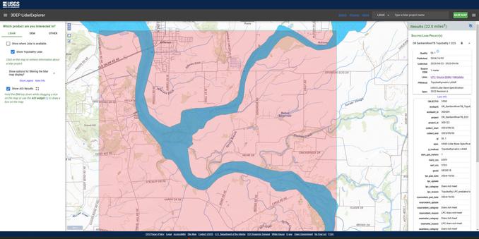
https://apps.nationalmap.gov/lidar-explorer/#/ <-- USGS 3DEP LiDAR Explorer (open data)
--
#GIS #spatial #mapping #remotesensing #LiDAR #topobathymetry #topobathy #example #usecase #wildfires #rivermanagement #climatechange #waterresources #SantiamRiver #Oregon #KlamathRiver #PotomacRiver #ColoradoRiver #USGS #USACE #3DEP #opendata #topography #elevation #3DTNM #water #hydrology #hydrospatial #pilotproject #prototype #infrastructure #navigation #engineering #riverbed #sediment #sedimentation #habitat #river #waterbody #flowmanagement #dams #salmon #steelhead #fish #WillametteValley #flood #flooding #risk #hazard #model #modeling #FIM #watersupply #agriculture
@USGS @USACE
--
https://www.usgs.gov/news/national-news-release/new-usgs-dataset-uncovers-santiam-rivers-underwater-topography-aid-fish <-- shared article
--
https://apps.nationalmap.gov/lidar-explorer/#/ <-- USGS 3DEP LiDAR Explorer (open data)
--
#GIS #spatial #mapping #remotesensing #LiDAR #topobathymetry #topobathy #example #usecase #wildfires #rivermanagement #climatechange #waterresources #SantiamRiver #Oregon #KlamathRiver #PotomacRiver #ColoradoRiver #USGS #USACE #3DEP #opendata #topography #elevation #3DTNM #water #hydrology #hydrospatial #pilotproject #prototype #infrastructure #navigation #engineering #riverbed #sediment #sedimentation #habitat #river #waterbody #flowmanagement #dams #salmon #steelhead #fish #WillametteValley #flood #flooding #risk #hazard #model #modeling #FIM #watersupply #agriculture
@USGS @USACE
New USGS dataset uncovers the Santiam River’s underwater topography to aid in fish habitat and water flow management | U.S. Geological Survey
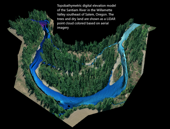
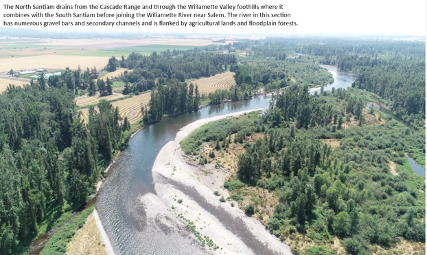
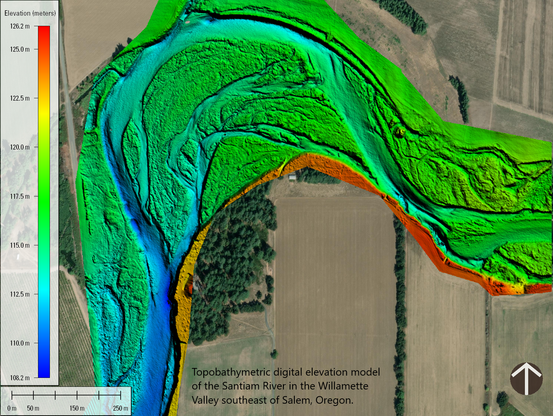
A new dataset for the Santiam River in Oregon, published by the U.S. Geological Survey, provides a highly detailed underwater 3D elevation map that will help support fish habitat restoration and flood modeling work.
