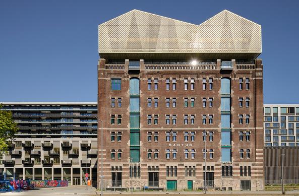
https://gombau.photo/seis-millones-fotos-edificio-centenario/ https://instagr.am/p/DV1l3a-lIHu/
Recognition in the recent report from Aviva and in The Guardian on the part #naturalfloodmanagement has to play in meeting the increased flood risk UK communities are having to deal with.
#remotesensing & #gis can help #nfm schemes in building the evidence base for their use https://www.mdpi.com/2335050
https://www.theguardian.com/environment/2025/oct/14/millions-more-homes-in-great-britain-at-risk-of-flooding-investigation-finds?utm_source=substack&utm_medium=email
https://static.aviva.io/content/dam/aviva-corporate/documents/newsroom/pdfs/reports/building_future_communities_report_2025.pdf
Meaningful corporate #climate emissions reduction, & meaningful tree planting that’s fit for futures, farming, #food production, quality localised timber economy & strategically planned & placed #hedgesandedges integrated with other #NFM techniques that meaningful slow the flow.
Additional #Carbon stored is a Blodwyn bonus - existing stores their protection is key, & freshwater needs a #freshwaterforest where ever it flows in peak flow.
https://www.gov.wales/updated-plans-sustainable-farming-announced
1/2. 40 mins between videos, the 1st video the waters were only on the Blackweir playing fields, the 2nd video creeping over the Pontcanna side playing fields. The waters weren’t at peak flow then #Cardiff. Pontypridd flooded again.
5 years I’ve been making the case for #NFM & #HedgesAndEdges. #Wales approx 80% plus farmland. The Sustainable Farming Scheme can begin to reduce peak flows for downstream community.
Fund Natural Water Management now & https://www.woodlandtrust.org.uk/protecting-trees-and-woods/campaign-with-us/agroforestry-in-wales/ #flood #climatechange
This study proposes an evaluation method using C-band Sentinel-1 synthetic aperture radar (SAR) data to provide evidence of flood characteristic changes after the restoration of a floodplain. A portable, flexible evaluation framework has replicated previous change detection research approaches to analyse a Natural Flood Management (NFM) project on the Sussex Ouse river in southern England, conducted by the Sussex Flow Initiative (SFI), to ascertain how control measures have helped mitigate flood risk. GIS operations were conducted on the mapped results of the change detection procedure to identify how flood area, form and compactness have been affected after the NFM installation restored a floodplain to slow river flow and how these changes relate to the overall aims of the project. Innovative means were employed to verify the change detection methodology by sampling flood records from internet-published drone footage. The overall accuracy achieved using the Change Detection and Thresholding (CDAT) technique was 75%. The use of SAR data provides evidence of how NFM features function during significant flood events, providing a mapped delineation of the actual flood extent. A comprehensive scorecard has been developed to evaluate the positive and negative outcomes of the spatial changes that have manifested in post-restoration floods, in comparison to inundation before the installation. Results from this study have been included in the annual report of the SFI project to demonstrate how key features have attenuated flood waters in accordance with design intentions.
Der renommierte deutsche Dirigent und Pianist Christoph Eschenbach wurde zum neuen künstlerischen Leiter des Nationalen Musikforums NFM in Wrocław ernannt. Seine Amtszeit beginnt mit der Saison 2024/25.