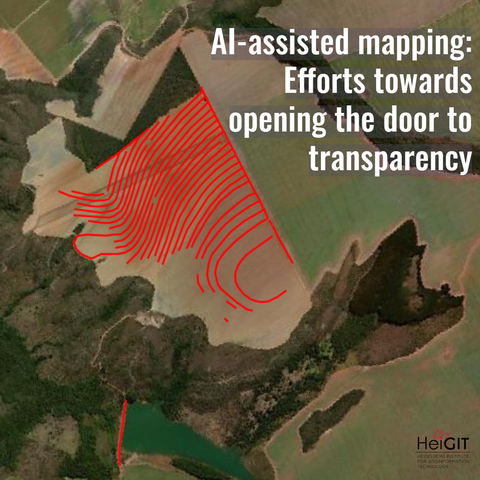
What role does the human-in-the-loop play in AI-assisted mapping?

In a recent experiment with YouthMappers in Ghana, we explored how editors interact with AI-generated roads in #OpenStreetMap. Do human edits refine the data or simply pass it through?

Understanding these actions helps improve trust, validation, and quality. It also guides how the community works with growing AI-generated data. What is your take on AI-mapping?

🔗 https://heigit.org/ai-assisted-mapping-insights-from-the-community/

#AIMapping #GeoAI #VGI #GIS

Review of the AI Segmentation by TerraLab plugin for QGIS

https://videos.qwast-gis.com/w/cw6ATTq1PeKEBAazkH1XHU

Review of the AI Segmentation by TerraLab plugin for QGIS

PeerTube
Review of the QGIS GeoAI plugin

PeerTube
New research highlights how AI-driven models are reshaping spatial analysis and land-use planning—integrating large-scale data, predictive modeling, and decision support into geographic workflows.
But the real shift is not just better analysis: planning itself becomes a data-driven, continuously updated process, where models increasingly co-produce spatial decisions.
#AI #GeoAI #UrbanPlanning
https://www.mdpi.com/2073-445X/15/3/460
https://doi.org/10.3390/land15030460
(Open) Webinar - Introduction to ML/DL Theory - Explore the foundational theory behind Machine Learning (ML) and Deep Learning (DL) in a geospatial context
--
https://events.teams.microsoft.com/event/f6f7b736-1fa2-4934-aee9-895685232fb4@05c95b33-90ca-49d5-b644-288b930b912b <-- shared webina registration
--
H/T Eric Loubier | DG, Canada Centre for Mapping and Earth Observation
“🌎 GeoAI Webinar Series
March 5, 2026 (11:00 am–3:00 pm ET)
Module #1: Introduction to ML/DL Theory
• Explore the foundational theory behind Machine Learning (ML) and Deep Learning (DL) in a geospatial context…”
#webinar #open #free #GeoAI #UNGGIM #ArtificialIntelligence #Geospatial #Webinar #Canada #Americas #eLearning #onlinelearning #AI #NorthAmerica #Algorithms #Architectures #ML #DL #GIS #spatial #mapping #machinelearning #deeplearning #usecase #workflow #spatialdata #remotesensing

🕶️ The Dark Side of #GeoAI – Workshop @ GeoAI 2026 🌍

Join us in mapping the risks, biases & dangers lurking in AI usage in the Geosciences — from hallucinations & bias to misinformation & ecological impacts — and developing countermeasures together.

📍 In beautiful #Ghent, Belgium 🇧🇪
📅 June 3, 2026 (afternoon)

✨ Open to ALL career stages & disciplines, not just geoscientists

📝 Submit by March 13:
A short statement of interest to [email protected]

Details: https://www.uni-muenster.de/Geoinformatics/en/sitcom/darkside.html

The Dark Side of GeoAI

Our online course on Spatial Data Science in Python has opened registrations once again. This time, we're teaching during May 2026.

10 lessons during May, covering everything from introduction to spatial data to #geoAI using Python open-source stack, part of which I've been actively developing for quite a while. Spatial graphs, autocorrelation, interpolation, point patterns, regression and spatial ML, all covered!

See the details at https://martinfleischmann.net/sds/micro/

A course on Spatial Data Science – Spatial Data Science in Python

New video: review of the AI Segmentation by #TerraLab plugin that allows smooth image segmentation in QGIS based on Meta's Segment Anything Model. Watch it on: 📺YouTube: youtu.be/oKxh8ldYflM 📺QwastTube: videos.qwast-gis.com/w/d8RMLJzcm1... #QGIS #GeoAI #segmentation #SAM #OpenSource #GIS

Review of the AI Segmentation ...
Review of the AI Segmentation by TerraLab plugin for QGIS

YouTube

Review of the AI Segmentation by TerraLab plugin for QGIS

https://videos.qwast-gis.com/w/d8RMLJzcm1gXZt8z6pQMKQ

Review of the AI Segmentation by TerraLab plugin for QGIS

PeerTube
議員: 用無人機搵路邊雜草 指路邊雜草叢生影響市容 無人機科技巡視雜草黑點
民建聯立法會議員周浩鼎 2月 4日於立法會會議就街道雜草問題提出書面質詢,運輸及物流局局長陳美寶作書面回覆。周 […]
#航拍 #AI #GeoAI #RDDS
https://unwire.hk/2026/02/04/chow-ho-ding-weeds-ai-rdds-hongkong/life-tech/drone/?utm_source=rss&utm_medium=rss&utm_campaign=chow-ho-ding-weeds-ai-rdds-hongkong