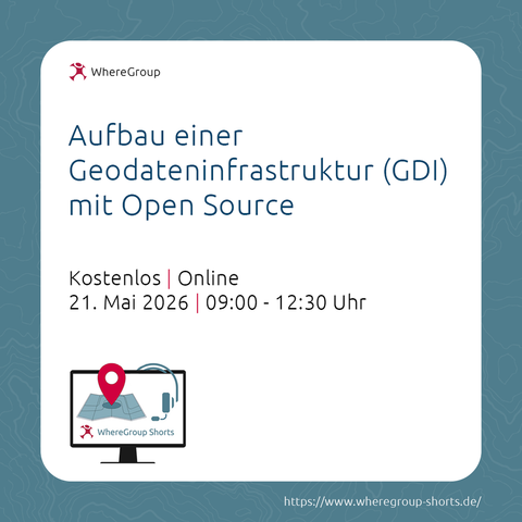
QField-FOSSGIS2026-APP @opengisch für Android Smartphone, Tablet und iOS ist verfügbar.
https://fossgis-konferenz.de/2026/programm/APPs.php#QFieldAPP

Greife mit der QField-FOSSGIS-App auf das #FOSSGIS2026 Programm zu und erkunde des Konferenzstandort in der Karte. Erstelle Deine persönliche Liste mit Workshops und Vorträgen.

#FOSSGIS #OpenStreetMap #OSGeo #QField ##göttingen

Qfield and PostGIS using VPN

PeerTube

FOSS4G 2025 Auckland recap: QField is production infrastructure now.

The pattern across deployments: QGIS Desktop → QField (offline) → QFieldCloud → Enterprise APIs

Not "can this work?" anymore. It's "how do we optimize this workflow?"

#FOSS4G2025 #QField #OpenSourceGIS

https://buff.ly/Laf6wAt

🖼️ #Qalendrier - jour 23

Aujourd'hui on fête la sortie de QField 4, au travers de cette référence géomusicale de 1979 🪩

#Qalendar #QField #gischat

Hi fellow #Qfield users,

I need your help to find a good name for a small QField plugin I’m building.
It automatically reopens a form after saving, making fast data entry much easier.

Right now, I’m hesitating between two ideas:
- QuickEntry
- BoxBox!

Which one would you choose? If you have any other ideas, let me know!

I like to verify my remote-sensing results directly in the field. Besides basic self-validation, field walks often generate new ideas and hypotheses.

For mobile field GIS, I use QField, loading both final map layers and custom templates for data collection.
Here’s an example from Nose Hill Park, where I checked several locations that showed a consistent NDVI increase in 2025 compared to 2024.
Field observations help confirm whether the spectral trends match real vegetation changes on the ground.

#RemoteSensing #EarthObservation #GIS #QGIS #QField #NDVI #VegetationMonitoring #Sentinel2 #FieldWork #GeoSpatial #OpenData #GeoDataScience #UrbanEcology #Calgary #NoseHillPark #Alberta #Canada #Copernicus #CopernicusSentinel #GreennessOfCalgary

We were delighted to join the @georomandie in Lausanne on November 13th.
It was great to present @qfield, #QGIS, #Georama, and #Egeniouss, and to connect with so many engaged geospatial professionals.

Thanks to everyone for the inspiring conversations and your interest in open-source innovation!

#opensource #qgis #qfield #qfieldcloud #georama #fieldwork #horizoneurope #innovation #geolocation #smartcities #lausanne #gis

I’m super excited to head to @FOSS4G2025 next week, and honestly amazed by what you can do with #QField nowadays.
The QField-based conference app gives you a searchable schedule, multi-floor room maps, real-time transport info, points of interest, and a private place for your own notes and photos — all offline 🚀

Just install @qfield and go to https://onelink.to/foss4g25

See you there!

Hey masto, I am looking to purchase a rugged tablet for #GIS applications (#QGIS, #QField) in #archaeology (mainly to work in caves, where humidity can reach 90%). I am looking for a model that can run Ubuntu (not Windows or Android). Ruggtek seems to sell what I'm looking for (https://www.ruggtek.com/en/product/rtl613/). Do you have any other recommendations? All feedback is welcome! #gischat

cc @jeremy

RTL 613

High-performance tablet PC, Intel Core i5, Windows 11, 12" 1920x1200 display. Memory 16/128 GB, multi-touch touchscreen.

Ruggtek

Vom Papierbogen zum digitalen Qualitätsmonitoring 🗺️🖥️

Für die Deutsche Wanderverband Service GmbH (DWV) haben wir eine Geodaten-Infrastruktur entwickelt, mit der Wanderwege digital und präzise erfasst werden. So wird die Qualität effizient geprüft und Zertifizierungen laufen schneller – ein Meilenstein für den DWV. 💪

Ein Workflow aus #Mapbender, #QGIS, #QField, #QFieldCloud und #PostGIS sorgt für strukturierte Datenerfassung und Auswertung.

Mehr im Blog 👇
https://wheregroup.com/blog/details/entwicklung-eines-geodatenbasierten-digitalen-qualitaetsmonitorings-fuer-die-deutsche-wanderverband-service-gmbh/