This is one of the few places I'd expect a wildfire to break out.

Wildfire breaks out near Sisimiut, Greenland.

#EU #CopernicusMission #EO #Sentinel2

https://eu-space.europa.eu/components/earth-observation-copernicus/image-of-the-day/wildfire-breaks-out-near-sisimiut-greenland

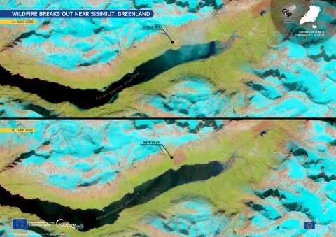
Wildfire breaks out near Sisimiut, Greenland | EU Space Support Office

On 14 June 2026, a wildfire was reported close to the Kangerluarsuk Ungalleq fjord, north-east of Sisimiut, Greenland’s second-largest city. The fire broke out in a largely ice-covered landscape of rocky terrain and sparse vegetation.

EU Space Policy
Huzzah! The remarkable and rather expensive, but totally worth it, transformation of the Washington DC Reflecting Pool from long green lake to long slightly greener lake is complete! As seen by #Sentinel2 from 28 February to 13 June #ReflectingPool #Algae

Auf der Insel Yos Sudarso in Indonesien zeigt der Vergleich von #Copernicus #Sentinel2-Aufnahmen aus den Jahren 2018 und 2026 eine deutlich dichtere Vegetation in Küstengebieten.

Die Entwicklung steht im Einklang mit aktuellen Erkenntnissen, wonach sich #Mangroven in vielen Regionen durch geringere #Entwaldung und Wiederherstellungsmaßnahmen erholen.

https://eu-space.europa.eu/components/earth-observation-copernicus/image-of-the-day/mangrove-recovery-yos-sudarso-island-indonesia

#Indonesien #Biodiversität #Naturschutz #environment #biodiversity

Mangrove recovery in Yos Sudarso Island, Indonesia | EU Space Support Office

According to a study recently published in the scientific journal Science, global mangrove loss has slowed after decades of widespread decline linked to aquaculture, agriculture practices, and coastal development.

EU Space Policy
Mt Aspiring area South Island New Zealand under clear high pressure conditions seen by #Sentinel2 on 9 June 2026 #NewZealand #SouthernAlps
The criminal destruction of Antelope Reef by China in it's turf war with Vietnam in only a few months. Atoll reefs are getting destroyed shockingly quickly by dredged sand in a stupid fight for territory. Seen by #Sentinel2 #AntelopeReef
Need an easy way to lookup upcoming Sentinel-2 and/or Landsat overpasses? The good news is there are three S-2 satellites in operation so more overpasses than ever (this yr only!). The bad news is a lot of the tools out there are outdated and will give you incorrect answers, including LLMs! Your best option for a quick answer is https://spectator.earth/ which I've verified as correct and will give you two weeks in advance if you register a free account. (1/2) #earthobservation #Sentinel2
Spectator | Real-Time Satellite Monitoring

Access the latest satellite imagery, plan future satellite acquisitions for any area in the world and integrate with your app through an API!

Spectator | Real-Time Satellite Monitoring
#Sentinel2 captured pumice rafts, steam plumes, and hot rock/surfacing lava heat signatures off the Bismarck Sea undersea eruption on 15 May.

Fascinating patterns on the water in the Strait of Hormuz (Apr 22, 2026). On the upper right it looks to me like there's a contrail from fast moving aircraft near the surface of the water (maybe). Large ship going left to right. What the heck is going on with the water's surface, is what i want to know... green stuff -- algae? white stuff-? Not what you normally see in Southern California. It seems to be on the surface as the ship is disturbing the pattern... "sea snot" algae?

26.757, 56.721

#satelliteimaging #Sentinel2

Seringapatam Reef in the Timor Sea seen on #EarthDay by #Sentinel2 this morning.