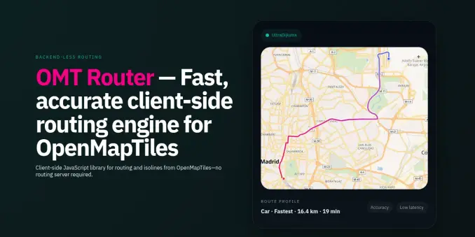
Announcing OMT Router — a client‑side routing library that builds #routing graphs from #OpenMapTiles vector tiles and computes routes + isolines in the browser. Zero‑backend, multi‑engine, AI-driven, and a custom control for easy #MapLibre integration. https://abelvm.github.io/omt-router/
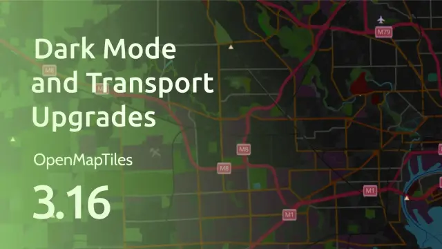
OpenMapTiles v3.16 is out now. It includes several transportation layer improvements and stability fixes. The update is already reflected in the OpenStreetMap MapTiler OpenStreetMap style.
Read more: maptiler.link/4cnP2Pb
#OpenMapTiles #OpenSource #OSM #OpenStreetMap
Heute einiges geschafft.
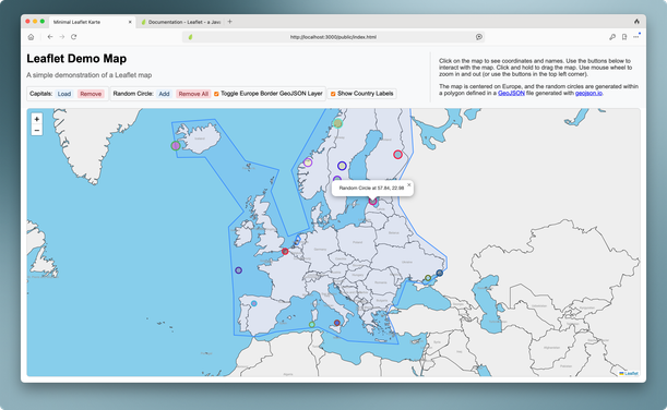
Leaflet mit Kartendaten gefüttert und ein wenig mit GeoDaten und GeoPunkten herumgespielt. Sogar einen mbtiles-Host gefunden, der vorgenerierte Kartendaten für die Niederlande und Europa bereitstellt – super! Damit konnte ich sogar einen MapTile-Server aufsetzen und schicke MapTiles unter meine GeoObjects legen.
Blogposts folgen. Gute Nacht!
https://codeberg.org/cblte/leaflet-hono-offline
#leaflet #geodata #mbtiles #openmaptiles
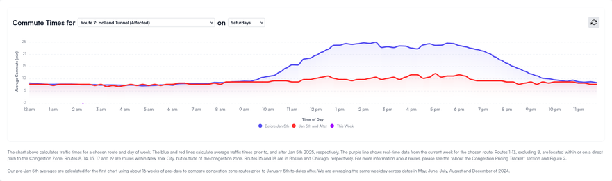
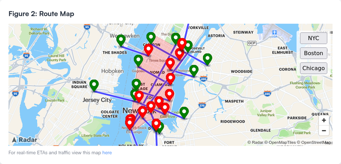
#NYC started implementing #CongestionPricing and two brothers made a tracker for it, which includes a map made with #OpenStreetMap data via #OpenMapTiles
https://congestion-pricing-tracker.com/
They also have another map, showing real-time traffic, using #GMaps
via: https://theverge.com/2025/1/16/24344732/nyc-congestion-pricing-tracker-data-google-maps

I need some help with #openmaptiles
I run "quickstart.sh", so far so good
Now: how do I serve the tiles and browse them ?
The QUICKSTART.md file suggests
make start-maputnik
I try, something happens but then the promt is given me back and there's no local service, as far as I can tell
I posted this question
https://community.openstreetmap.org/t/stuck-trying-to-run-openmaptiles/115164

Stuck trying to run openmaptiles
I’d like openmaptiles running a local web server and I’d like to be able to connect to it and see my square of land rendered with my style of choice I downloaded a custom square of land and I made openmaptiles digest it I run quickstart.sh, it run successfully, so far so good but then how do I run a local web server ? In the QUICKSTART.md file there are some suggestions, like (on line 424) Hints for designers: make start-maputnik # start Maputnik Editor + dynamic tile ser...
Wochenrückblick, Ausgabe 45 (2024-24).
Diesmal mit
→ 🗺️ Umstellung der Tileserver-Software für das Bikerouter Gravel-Overlay und Umzug auf neuen Server
→ 🗺️ Update des Gravel Overlays mit aktuellen Daten
→ 🧑🍳 der gewonnenen Erkenntnis darüber, was der Backofen macht, wenn man die Tür offen lässt, den Ofen aber eingeschaltet lässt
→ 🚣 mit dem Ruderkahn unterwegs zum Genießen und Squadratinhos sammeln
→ 🍎 diesmal ausnahmsweise keine Apps mit „L“
→ 🔊 Techno
#Bikerouter #GravelOverlay #OpenMapTiles #mbtileserver #mbtiles #VeloViewer #Backen #BrotBacken #Backofen #Kahn #Ruderkahn #Squadrats #Techno

Rückblick Kalenderwoche 2024-24
→ Umstellung der Tileserver-Software für das Bikerouter Gravel-Overlay und Umzug auf neuen Server → Update des Gravel Overlays mit aktuellen Daten → was der Backofen macht, wenn man die Tür offen lässt → mit dem Ruderkahn unterwegs zum Genießen und Squadratinhos sammeln → Techno
#OpenMapTiles 3.15 is out! The main changes include
* Big improvements to the road network
* More water features
* Integration of Aboriginal lands
* Extra functionality for adding the most requested data & improving cartography


#OpenMapTiles 3.15 was released today, see https://www.maptiler.com/news/2024/04/openstreetmap-data-prepared-for-advanced-cartography/ .
Why I'm writing this: It is part of my work with #MapTiler to port those changes into `planetiler-openmaptiles` (e.g. from SQL to Java). And version 3.15 of that tool will follow in a short while.
Thanks to colleagues and people from the community it is a very pleasant work. And coming from non-GIS background I also learned a lot about maps and #OpenStreetMap. Big thanks.