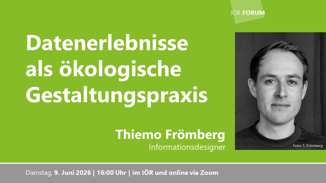
#Niantic created #PokemonGo

An app that millions of users used, ran around their regions, and took pictures with all location and sensor data of their surroundings.

Hard to get regions, different times, phones, weather. TONS of valuable data!

This data is now used in a positioning model, and allows them to track you wherever you are, based on a single image.

If Youtube doesnt block you, watch it there. Video shared for archival purposes.

https://youtu.be/Vk95ZO-WAvY

#MassSurveillance #GeoData #Bigdata #Surveillance #Tracking #Pokemon #Anonymity

GitHub - rupestre-campos/geofastmapAPI

Contribute to rupestre-campos/geofastmapAPI development by creating an account on GitHub.

GitHub
Cercare bandi, in Italia, è sempre stato un esercizio di resistenza più che di intelligenza: pagine su pagine, portali che sembrano progettati per scoraggiare, sigle che si rincorrono come se avessero paura di farsi capire. Non è complessità, è disordine organizzato, una nebbia che ti fa perdere tempo e lucidità.

Vistagare non semplifica il mondo, che sarebbe una promessa da venditori di tappeti, ma lo rende leggibile. Prende quel rumore e lo stende su una mappa, lo attraversa con un filo logico, lo espone senza chiederti di diventare un archeologo dei PDF. E poi ci mette sopra una cosa che fino a ieri non c’era: una voce che risponde, che collega, che ti restituisce senso.

Non è magia. È struttura.

E succede una cosa curiosa: mentre altri continuano a cercare, a scavare, a inseguire link e aggiornamenti, tu inizi a riconoscere i pattern, a vedere prima, a muoverti con un passo diverso. Non più dietro alle informazioni, ma dentro.

Il vantaggio non è trovare un bando.
È smettere di perderti nel cercarlo.

https://vistagare.it

#vistagare #bandi #garepubbliche #appalti #intelligenzaartificiale #ai #businessintelligence #datadriven #govtech #procurement #tender #startupitalia #saas #automation #analytics #geodata #mappe #digitalizzazione #pmi #imprese #innovazione #efficienza #produttività #opportunità #growth #leadgeneration #osint #techitalia

Wie lässt sich aus offenen 🌐 Geodaten ein Mehrwert für Gesellschaft und Wissenschaft gewinnen (und das nicht nur durch Fachleute)? Dieser Frage geht die aktuelle Frühjahrsreihe des IÖR-Forums nach. Alle Veranstaltungen und Informationen 👉 https://www.ioer.de/veranstaltungen/ioer-forum/ioer-reihe-geodaten-nutzbar-und-erlebbar-machen

#IOER_FDZ #GeoData #NFDI
@BERD_NFDI @NFDI @nfdi4earth @konsortswd @saxfdm @a_tack

control #OpenLayers with your hands via webcam

"Map Gesture ControlsControl maps with your hands
Browser-native hand gesture controls for OpenLayers. Powered by MediaPipe. No backend required."

#gis #gistribe #gischat #webmap #geodata #geospatial

https://sanderdesnaijer.github.io/map-gesture-controls/

Map Gesture Controls - Hand Gesture Navigation for OpenLayers Maps

Control OpenLayers maps with hand gestures using your webcam. Browser-native, privacy-first, powered by MediaPipe.

Map Gesture Controls

@wesense project is in early stage, but looks promising. A decentralized network of ever free global sense data from citizen networks? Yes please. Worth keeping an eye on.

#sensor #OpenData #citizenscience #geodata #Environment

https://wesense.earth/

WeSense.earth — Sense Your World. Share Our Planet.

WeSense.earth — A peer-to-peer, community-owned environmental sensor network. Sense your world, share our planet.

Spanish startup Xoople is developing a satellite constellation to collect precise physical earth data aimed at feeding into deep learning models. Announced Series B Funding ($130M) and a deal with L3Harris Technologies to begin building sensors for its spacecraft.

Xoople claims it will deliver reliable ground-truth data about the physical world with precise, continuous context and deep time-series measurements with unparalleled quality and global coverage.

https://www.xoople.com/resources/xoople-announces-130m-series-b-to-build-earths-system-of-record-for-the-agentic-era/ #Space #Xoopie #Earth #Data #GeoData #Cloud #Software #Satellite #SpaceCraft #LLMs #AI

*Artigos científicos* 1/2

Estudo interessante @heigit sobre integração #geodados rodoviários assistida por #IA no #OpenStreetMap
Quanto mais correções são feitas com #HumanInLoop, menor #transparência e #rastreabilidade da #QualidadeDosDados
Pessoalmente, sempre me recusei a passar de artesão qualificado para controlador produtos padronizados, mas aqui novo argumento para não introduzir #IA #geodata no #OSM. Solução: #mashup #OSM + dados de IA para preencher lacunas.
https://www.tandfonline.com/doi/full/10.1080/24694452.2025.2589286

*Scientific papers* 2/2

A #lowcost #deeplearning methodology integrating #OpenStreetMap for #urban planning tasks across multiple domains. #OSM #vectors serve as reference masks for #satelliteimagery to enable predictions via #CNN and #GNN. Accuracy >90%.
New #remotesensing products require #vector #geodata. Hence the value of investing in the completeness and consistency of #OSM data
https://www.
nature.com/articles/s41598-026

*Scientific papers* 1/2

Interesting study by @heigit on #AI-assisted integration of road #data into #OpenStreetMap, which shows the more corrections made using #HumanInLoop, the less #transparency and #traceability regarding #DataQuality
Personally, always refused to switch from being a skilled craftsman to a controller of standardized products, but here’s another argument against introducing #AI #geodata into #OSM. Solution: #mashup #OSM + AI data to fill in the gaps.
https://www.tandfonline.com/doi/full/10.1080/24694452.2025.2589286