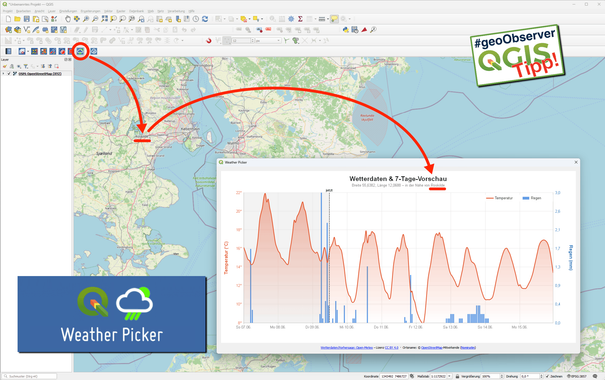
In Kooperation mit GoGeoGo gibt es bis zum 09.04.2026 eine digitale Jobbörse. Beim Eintragen bitte die Auftragsnummer `FOSSGIS2026 eintragen, dann erscheint die Stellenanzeige in der #FOSSGIS2026 Jobbörse.
https://fossgis-konferenz.de/2026/#Jobwand

Darüber hinaus stellen wir eine Pinnwand ins Foyer, dort können Stellenanzeigen angebracht werden.

#FOSSGIS #OpenStreetMap #OSGeo #Geojobs

Just published a tutorial about using GRASS for a viewshed workflow that employs an observer-relevant surface to selectively represent obstructions that effectively block line of sight at pedestrian height. This derived layer is then used to perform a cumulative viewshed analysis. Check it out here: https://ecodiv.earth/post/intervisibility/ #grassgis #osgeo #ahn #viewshed @grassgis

QField-FOSSGIS2026-APP @opengisch für Android Smartphone, Tablet und iOS ist verfügbar.
https://fossgis-konferenz.de/2026/programm/APPs.php#QFieldAPP

Greife mit der QField-FOSSGIS-App auf das #FOSSGIS2026 Programm zu und erkunde des Konferenzstandort in der Karte. Erstelle Deine persönliche Liste mit Workshops und Vorträgen.

#FOSSGIS #OpenStreetMap #OSGeo #QField ##göttingen

#FOSSGIS2026 Programm-APP für Android Smartphone und Tablet @tbsprs im Playstore und F-Droid verfügbar: https://fossgis-konferenz.de/2026/programm/APPs.php#FahrplanAPP

Erstelle Deine Favoriten und Helferschichten zur #FOSSGIS2026 in einer App.

#FOSSGIS #OpenStreetMap #OSGeo

We are happy to announce the release of #OSGeo #deegree #webservices version 3.6.7 which includes bug fixes and enhancements. Check out here https://github.com/deegree/deegree3/releases/tag/deegree-3.6.7
„Maps oder Die Aneignung von Welt(karten) | Malerei auf Schullandkarten” / “Maps or The Appropriation of the World (and Maps) | Painting on School Atlases” https://geoobserver.de/2026/03/20/maps-oder-die-aneignung-von-weltkarten-malerei-auf-schullandkarten/ #gistribe #gischat #fossgis #foss4g #OSGeo #spatial #geospatial #opensource #mapping #DataViz #gis #geo #geoObserver pls RT
The 2026 MapServer User Survey will be closing at the end of the month, so if you've not had a chance to respond here's the link https://docs.google.com/forms/d/e/1FAIpQLSfNLqslbM6IhocnwTst9c29eaD89yD81hdUKW2ctn2uZK0Z3g/viewform #mapserver #osgeo #gischat
2026 MapServer User Survey

The MapServer Project Steering Committee (PSC) would love to get your feedback on MapServer. Your input will help us understand how the project is being used and guide the development of its future roadmap. The survey will be open until the end of March 2026. Providing your name and email is entirely optional. All responses, including names and emails (if provided), will remain confidential. No identifying information will be published, and results will be aggregated and anonymised. Thank you for your valuable time and feedback. To make the survey more effective, please help us by sharing it widely.

Google Docs
DataViz: "Wahrnehmung von Farben in Choroplethenkarten im Dunkelmodus" / "Perception of Colours in Choropleth Maps in Dark Mode" https://geoobserver.de/2026/03/19/dataviz-wahrnehmung-von-farben-in-choroplethenkarten-im-dunkelmodus/ #gistribe #gischat #fossgis #foss4g #OSGeo #spatial #geospatial #mapping #DataViz #gis #geo #geoObserver pls RT
FedGeoDay is now on ALL your favorite platforms! Follow us for updates on #FedGeoDay2026 — April 22–23 at US Census Bureau HQ. Keynotes, workshops & networking with federal geo leaders. Register: fedgeo.us #GIS #Geospatial #OpenData #FedGeoDay #FedGeoDay2026 #OSGeo

I've had a grand day out in beautiful South Wales doing PostGIS and tech lead bits.

Spent most of the day inside (naturally) but some cracking views from the train 🚄

#postgis #geo #osgeo @astuntechnology