Back into old-school: posting on my website: today flashback past 4 years professional life, developing maps, attending/presenting at FOSS4Gs, life&mapping in Spain etc:
https://justobjects.nl/adios-2022-2025/
https://justobjects.nl/adios-2022-2025/
| Web | https://geographika.net/ |
| GitHub | https://github.com/geographika/ |
Don't take too much care of your #JoyPlot.
https://teenusa.shop/campaign/damnit?s=hanes-5250&c=Black&p=FRONT

Remember 100 years ago when radiation was new and exciting and poorly understood, and companies were putting radiation into everything?
Thankfully we learned our lesson and will never make that mistake again.
FYI the website community page [1] now has a live deployments map!
Please feel free to add your own deployment(s) by updating [2], and/or add your organizational logo by opening an issue in [3]
Thanks
[1] https://pygeoapi.io/community
[2] https://github.com/geopython/pygeoapi/wiki/LiveDeployments
[3] https://github.com/geopython/pygeoapi.io/issues
GDAL and xarray, NCI and Pawsey, working together at last: https://github.com/mdsumner/virtualized/issues/12#issuecomment-4427816203
(learned heaps today!)
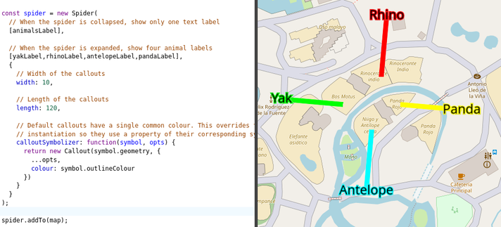
In today's #gleo news: symbolizer function for spider's legs.
It's a niche feature, but this allows for custom instantiation of the legs of a `Spider` symbol. In the REPL example, each leg uses the colour of the corresponding text label.
Another use is using a decorated `Callout` subclass, and using other properties of symbols for their legs.