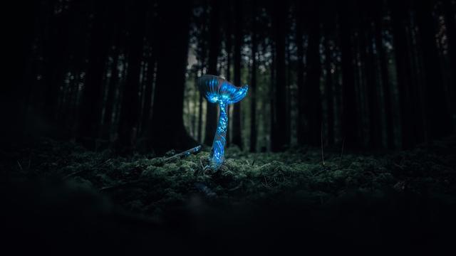
@mfuhrmann Hm? Erst mal die Gebäude; auch den Übergang. Dann #IndoorMapping der Stockwerke, Räume und Stützen. Gehen indoor da auch Tische? Die Regionen erst mal.
Weiter als #MicroMapping für die Geleise und Modellgebäude?! Da in #OpenStreetMap alles geht, geht auch alles in Miniatur. Was zeigen die 2D/3D Renderer da noch alles an? Terrain ist bei OSM ja noch mangelnd. Wie gehen in "echt" Tunnel und Berge? Selbst wenn 3D die height-tags berücksichtigt werden.
Die Standard- #VectorTiles reichen jedenfalls nicht. Aber man kann ja Zusätzliche parallel generieren.
Das #MiWuLa wäre eine Schweine-Arbeit! Wenn sie helfen, mit Plänen und Dateien, wird es 50% leichter. Hat schon mal jemand von #OSM mit denen gesprochen? Einfach mal fragen ...
Einige Teile sind ja 1:1 nach gebaut, also in OSM schon vorhanden. Könnte man kopieren.
Es gibt 3D Renderer, wo Autos fahren. Züge noch nicht, gell? Dafür FOSS-Bahn-Spiele. Und das dann in der VR-Brille - wild zu einem virtuellen Rundgang. Träum ...

This public consultation process for proposed cycleways in Nelson is cool, and they use MapBox as the map, which is directly based on #OpenStreetMap. This means that all the #OSM improvements me and a few others have made over the last several years, especially separated paths and #micromapping, is on full display! It makes the interactive map more useful because it's easy to identify where paths and crossings are, and areas are accurate and look very nice.

https://shape.nelson.govt.nz/east-west-cycle-link

#OSMNelson

East-West cycle link

Investigating a proposed active travel link from the Maitai/Brook areas in the east to the Railway Reserve corridor in the west

Shape Nelson

#MicroMapping #playground while doing #fitness. Each note/node equates to 6 pull ups, thus totalling up to 120 pull ups.

#OpenStreetMap #OsmAnd #UrbanFitness #calisthenics

Mon premier micromapping avec OpenStreetMap : un petit jardin dans le village de ma belle-sœur. Ce n’est pas hyper utile mais c’est joli :)

#micromapping #openstreetmap

Eu e @elmoneto atualizamos o mapa do Parque Evaldo Cruz, Campina Grande, no OpenStreetMap. O Parque tinha passado por uma reforma que o conectou ao Parque do Povo e agora está totalmente integrado às atividades do maior São João do Mundo. Agora ele conta também com o primeiro Jardim Sensorial público da Paraíba. O Jardim é um espaço de educação ambiental voltado para Pessoas com Deficiência, especialmente crianças neuroatípicas.

Link com todos os detalhes no OpenStreetMap: https://www.openstreetmap.org/way/216865704

#OpenStreetMap #QGIS #Mapeamento #Mapping #Micromapping

There is ongoing construction work for the new Nelson Bus Hub at Millers Acre, so I've made the building very detailed. Looking forward to micromapping the rest when it's nearly finished.  
#OpenStreetMap #OSM #OSMNelson #Nelson #WhakatūNelson #MicroMapping

@philip

It all depends on the level of details you want to add.

I start off with #ArmChairMapping and once have grabbed most major objects like buildings and landcover. Then I go to the streets to add more details like the values of the buildings and/or addresses.

#StreetComplete permits notes, though prefer to use #OsmAnd instead where I have created a set of quick actions to speed up the process. #EveryDoor in another favorite under #MicroMapping.

@aspensmonster

Just another park made pretty in OSM - it deserves more than just being a lonely green polygon! #micromapping
Lazy sunday #micromapping #osm