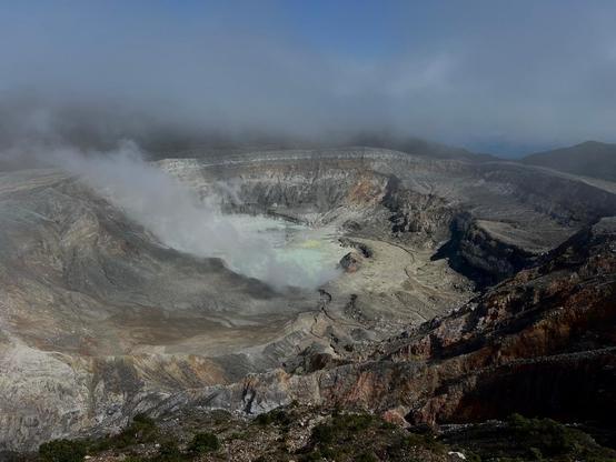
CNE declara alerta naranja para Parque Nacional Volcán Poás y Toro Amarillo
CNE declara alerta naranja para Parque Nacional Volcán Poás y Toro Amarillo Costa Rica - El Mundo CR
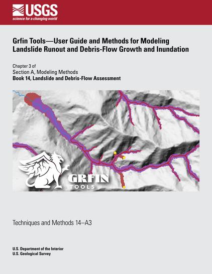
Grfin Tools—User guide and methods for modeling landslide runout and debris-flow growth and inundation
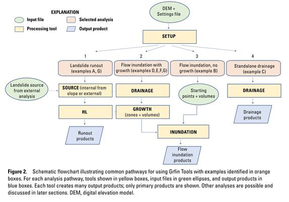
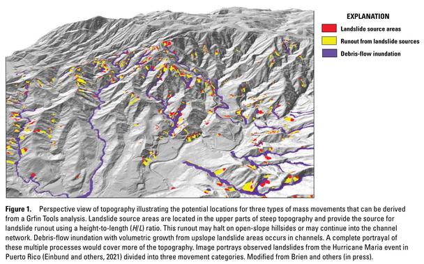
The software package, Grfin Tools, can estimate potential runout from landslides or inundation from geophysical mass flows such as debris flows, lahars from volcanoes, and rock avalanches within a digital elevation model (DEM). Grfin is an acronym of growth + flow + inundation. The tools within this package apply simple, well-tested, empirical models of runout that are computationally efficient and require minimal parameters. These tools can be used individually (for example, to estimate debris-flow inundation) or in combination to represent a more complete series of linked processes, from landslide source areas, to unchannelized transport, to channelized flows. Grfin Tools can rapidly assess potential runout and inundation over large areas and the results are readily visualized in a geographic information system.Tools for assessing areas affected by runout and flow inundation include a height-to-length (H/L) ratio, angle-of-reach approach for estimating open-slope, unchannelized landslide runout, and volume-area scaling relations for assessing flow inundation...
#Kanlaon has been under Alert Level 2 since June 3, following a “moderately explosive eruption” that forced residents living near the #volcano to evacuate, caused #ashfall, triggered #lahar and even killed thousands of farm animals.
An average of 10 volcanic #earthquakes per day has been recorded since the eruption, while Kanlaon’s edifice has been inflated or swollen since March 2022.
#KanlaonVolcano #SulfurDioxide reaches record high on June 28
https://www.rappler.com/philippines/visayas/phivolcs-kanlaon-volcano-update-advisory-june-28-2024-615pm/

Kanlaon Volcano sulfur dioxide reaches record high on June 28
'This is the highest emission from the volcano recorded since instrumental gas monitoring began,' says Phivolcs
Marapi Volcano Update; A Lethal & Destructive Lahar was Generated
#geology #volcano #lahar
https://youtu.be/5vSQFd8bi2k ?si=nj1Q5x6j2uWF5Qph

Marapi Volcano Update; A Lethal & Destructive Lahar was Generated
Dozens killed in cold lava mudslides on Indonesian island of Sumatra
Heavy rains triggered flash floods and caused torrents of cold lava and mud to flow down a volcano’s slopes on Indonesia’s Sumatra island, killing at least 41 people and leaving more than a dozen others missing, officials have said. Monsoon rains and a major mudslide from a cold lava flow on Mount Marapi caused a river to... #sumatra #indonesia #asiapacific #southeastasia #asia #lahar #lava #volcano #civilemergency #worldnews #worldwithoutus
https://www.theguardian.com/world/article/2024/may/13/indonesia-mudslides-sumatra-cold-lava-floods-death-toll-mount-merapi
Dozens killed in cold lava mudslides on Indonesian island of Sumatra
Nearly 20 missing after monsoon rains trigger flash floods, sending torrents of volcanic material and mud down slopes of Mount Marapi volcano
A 22-million-year-old petrified #mangrove forest found in the Panama Canal https://phys.org/news/2024-01-million-year-petrified-mangrove-forest.html
An early #Miocene (#Aquitanian) mangrove #fossil forest buried by a #volcanic lahar at #BarroColoradoIsland, #Panama https://www.sciencedirect.com/science/article/abs/pii/S0031018223006247
"approximately 1 million years after the formation of #BarroColorado Island, a #volcano erupted, followed by a #lahar, which covered the island with mud and rocks. It also covered the #MangroveForest that had grown around the edges of the island."


A 22-million-year-old petrified mangrove forest found in the Panama Canal
A team of environmental and natural scientists from Universidad EAFIT in Colombia, the Smithsonian Tropical Research Institute in Panama, and Boise State University in the U.S. has found evidence of an ancient petrified mangrove forest on an island in the Panama Canal. For their study, reported in the journal Palaeogeography, Palaeoclimatology, Palaeoecology, the group collected fossils and sediment samples from the island.
When they said, “#PugetSound is built on #Rainier’s mudflows,” I didn’t realize they meant that there was no land where Tacoma, Kent, Auburn, and Renton currently are before the colossal #OsceolaMudflow filled in those parts of Puget Sound 5600 years ago.
#seattle #geology #lahar #MtRainier #Takoma #volcano
Via the U.S. Geological Survey, on Tuesday, a small debris flow was detected by several of Mount Rainier's lahar monitoring stations, likely the result of an outburst of water from the South Tahoma Glacier that grew into a debris flow, which isn't surprising given the current heat wave in WA.
More from the USGS Volcanoes Instagram account: https://www.instagram.com/p/CwBew8mPJlb/?igshid=MzRlODBiNWFlZA==
#MtRainier #Lahar #Volcanology #Volcano #Tahoma #Geohazards #WA #Seattle #Tacoma #USGS

USGS Volcanoes on Instagram: "Monitoring stations detect a small debris flow at Tahoma Creek, in Mount Rainier National Park.
A small debris flow occurred in Mount Rainier National Park around 4:30 pm local time, on Tuesday, August 15, 2023. The debris flow did not travel far, remaining in the remote upper reaches of the Tahoma Creek drainage (see photo). Downstream of the event, water flowing beneath the Tahoma Creek road bridge (on the Nisqually-Paradise road) was reported as having a high sediment load and a distinctive “mud” smell. No damage was reported.
The small debris flow was detected by several lahar monitoring stations, some installed as recently as September 2022. The debris flow signal appeared very clearly on station TABR, located near the Tahoma Creek suspension bridge (see graphic). The strongest signal occurred when the front of the flow passed the station. High amplitudes continued for hours as the sediment-laden water washed downstream after the event ended.
The debris flow likely originated as an outburst of water from the South Tahoma Glacier that transitioned into a small debris flow. The area has been experiencing multiple days of extreme heat and a glacial outburst was not unexpected.
Mount Rainier National Park and USGS staff continue to work together to monitor activity at Mount Rainier and communicate hazard information.
#USGS #CVO #CascadesVolcanoObservatory
@MountRainierNPS"
94 likes, 1 comments - usgsvolcanoes on August 16, 2023: "Monitoring stations detect a small debris flow at Tahoma Creek, in Mount Rainier National Park.
..."

