Hancom InSpace gains hyperspectral sensor
https://fed.brid.gy/r/https://spacenews.com/hancom-inspace-gains-hyperspectral-sensor/
Hancom InSpace gains hyperspectral sensor
https://fed.brid.gy/r/https://spacenews.com/hancom-inspace-gains-hyperspectral-sensor/

PhD Project - An AI -aided data-driven approach to study the making, degradation and origin of historical parchments at Nottingham Trent University, listed on FindAPhD.com
【🎉Latest accepted article】
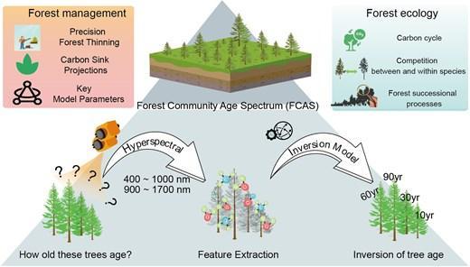
Estimating the Age of Larix gmelinii on Leaf #Hyperspectral Data: A Case to construct #ForestCommunityAgeSpectrum
#RemoteSensing | #MachineLeaning | #Inversion | #TreeAge | #Community
Ứng dụng ảnh vệ tinh siêu phổ trong nông nghiệp chính xác
Ảnh vệ tinh siêu phổ giúp nhận diện “chữ ký phổ” của cây trồng và đất, từ đó phát hiện sớm sâu bệnh, thiếu dinh dưỡng và tối ưu quản lý mùa vụ. Công nghệ này mở ra hướng đi bền vững cho nông nghiệp thông minh.
>>> Chi tiết tại: https://www.eov.solutions/post/hyperspectral-satellite-imagery-ho-tro-nong-nghiep-chinh-xac
#EOVSolutions #NongNghiepChinhXac #Hyperspectral #SmartFarming #AgriTech
Smartphone Cameras Go Hyperspectral
https://spectrum.ieee.org/hyperspectral-imaging
#HackerNews #Smartphone #Cameras #Go #Hyperspectral #hyperspectral #imaging #smartphone #technology #camera #innovation
Computational photography spectrometry:
#photography #spectrometry #hyperspectral #research #science
📸
https://techxplore.com/news/2025-09-image-algorithm-hyperspectral-info-conventional.html

Professionals in agriculture, defense and security, environmental monitoring, food quality analysis, industrial quality control, and medical diagnostics could benefit from a patent-pending innovation that opens new possibilities of conventional photography for optical spectroscopy and hyperspectral imaging.
New in Geodata Ramblings blog: Part 2 of posts about using Wyvern's hyperspectral imagery Open Data Program, for Harmful Algal Bloom (HAB) detection. Let's port the pipeline to the Dagster data orchestrator package!
https://ricegeo.dev/hab-detection-wyvern-hsi-dagster/
#hyperspectral #earthobservation #geospatialdata #remotesensing
#betterearth #python #dagster

