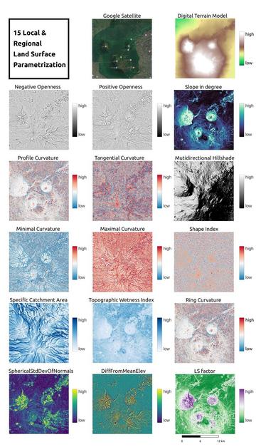
After several weeks of thinking and DEM preprocessing, I finally generated a complete geomorphons map for the part of Inhulets River basin (Ukraine).
It was far from easy — the original Copernicus GLO-30 DEM required careful cleaning, correction, and multi-step preparation before meaningful terrain forms could emerge.

What makes geomorphons truly valuable for me is how well they correspond to geochemical landscape types — eluvial, transeluvial, superaquatic, and subaquatic zones.
This overlap allows interpreting geomorphons as functional terrains with distinct element migration patterns, bridging geomorphology and environmental geochemistry.

All computations were done using R + SAGA GIS + QGIS, with the excellent Rsagacmd package for seamless tool integration.

#Geomorphons #SAGAGIS #Rsagacmd #QGIS #Geochemistry #RStats #Geospatial #Hydrology #RemoteSensing #Copernicus #OpenData #GIScience #InhuletsRiver #EnvironmentalGeochemistry #FOSS

openlandmap/GEDTM30

Global Ensemble Digital Terrain modeling and parametrization at 30~m resolution (GEDTM30) - openlandmap/GEDTM30

GitHub
Assessing the Prediction Accuracy of Geomorphon-Based Automated Landform Classification: An Example from the Ionian Coastal Belt of Southern Italy

Automatic procedures for landform extraction is a growing research field but extensive quantitative studies of the prediction accuracy of Automatic Landform Classification (ACL) based on a direct comparison with geomorphological maps are rather limited. In this work, we test the accuracy of an algorithm of automatic landform classification on a large sector of the Ionian coast of the southern Italian belt through a quantitative comparison with a detailed geomorphological map. Automatic landform classification was performed by using an algorithm based on the individuation of basic landform classes named geomorphons. Spatial overlay between the main mapped landforms deriving from traditional geomorphological analysis and the automatic landform classification results highlighted a satisfactory percentage of accuracy (higher than 70%) of the geomorphon-based method for the coastal plain area and drainage network. The percentage of accuracy decreased by about 20–30% for marine and fluvial terraces, while the overall accuracy of the ACL map is 69%. Our results suggest that geomorphon-based classification could represent a basic and robust tool to recognize the main geomorphological elements of landscape at a large scale, which can be useful for the advanced steps of geomorphological mapping such as genetic interpretation of landforms and detailed delineation of complex and composite geomorphic elements.

MDPI