John Lindsay

@whiteboxgeo
258 Followers
170 Following
12 Posts
Creator of WhiteboxTools and co-founder of Whitebox Geospatial Inc. Professor at the University of Guelph, Department of Geography, Environment and Geomatics. #geospatial #GIS #geomatics #geomorphometry
homepagehttps://www.whiteboxgeo.com
topicsGIS, geomorphometry, geospatial, lidar, remote sensing, open-source

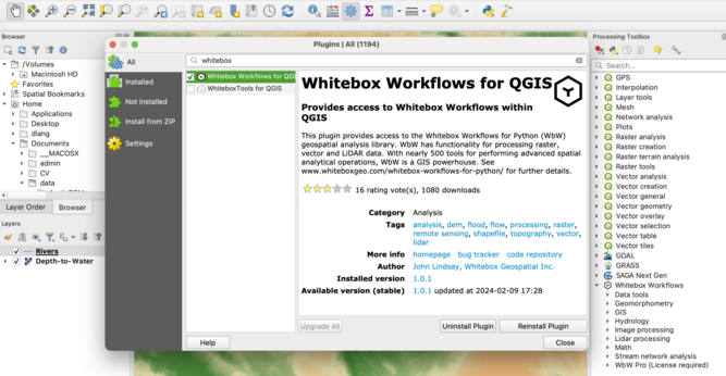
We've recently released a #QGIS plugin for Whitebox Workflows for Python (WbW). Now you can access this powerful #python #geoprocessing library from an easy-to-use GUI. #GIS #gischat #geospatial #mapping #spatialanalysis #geopython

QGIS plugin: https://plugins.qgis.org/plugins/whitebox_workflows_for_qgis/#plugin-about

WbW: https://www.whiteboxgeo.com/whitebox-workflows-for-python/

Whitebox Workflows for QGIS — QGIS Python Plugins Repository

Hey #geospatial experts! As of the v1.2 release, Whitebox Workflows for Python (WbW) is free. WbW is a Python library for advanced geoprocessing, including more than 400 functions for #gis and #remotesensing analysis. WbW enables you to write powerful geoprocessing scripts. #gischat #lidar

https://www.whiteboxgeo.com/whitebox-workflows-for-python/

The impoundment size index (ISI) in #WhiteboxTools is great! In the image, sites that are non-impoundable by a 25-m dam are white and the darker blue a pixel is, the larger the upslope impoundment is. ISI could be used for siting #wetland construction projects, #riverrestoration, #flood modelling, #gully mapping, hydroelectric dam siting, and many other applications. #hydrology #spatialhydrology #topography #gis #gismapping #spatialanalysis #lidar

https://www.whiteboxgeo.com/geospatial-software/

Geospatial Software: WhiteboxTools Open Core - Whitebox Geospatial Inc

Our fast, compact, and flexible open source geospatial software WhiteboxTools can help GIS analysts and practitioners process geospatial data

Whitebox Geospatial Inc

The EmbankmentMapping tool in #WhiteboxTools, transforms how DEMs are hydrologically corrected prior to analysis. This tool modifies fine #LiDAR DEMs by mapping and optionally removing road embankments that can present problems for some modelling. #DEMMapping #TransportationModeling #GIS #geospatial #QGIS #GeoNews #geomatics #gischat #hydrology #geomorphometry

https://www.whiteboxgeo.com/geospatial-software/

The #WhiteboxTools Isobasins tool can be used to break landscapes into roughly equal-size sub-basins (i.e., 'isobasins'). There are many applications, but I often reach for this handy tool to map the spatial pattern of phenomena that have to be measured over an area (e.g., #relief, total #sediment #erosion/deposition, etc.), but where the boundary between the areal units of measurement must be physically meaningful. #gischat #geospatial #opensource #geopython

https://www.whiteboxgeo.com/geospatial-software/

WbW_tutorial3

What a great looking group of geomorphometrists! #geomorphometry #geospatial #GIS #GISChat #geomatics #topography
I love the Qin (2007) flow accumulation algorithm in high-relief #topography.
#hydrology #GIS #GISChat #geospatial #geomatics

I've posted some Whitebox Workflows for Python (WbW) tutorials using Jupyter Notebooks that take users through hydrological and geomorphometric processing of DEM data.

--
https://jblindsay.github.io/WhiteboxTutorials/WbW_tutorials/WbW_tutorial1.html <- Tutorial link
--

#GIS #gischat #geomatics #geopython #geoprocessing #hydrology #geomorphometry #lidar #spatial #mapping #remotesensing #elevation #terrain #DTM #spatialanalysis #python #jupyter #jupyternotebook #3dmodel #DEM #height

WbW_tutorial1