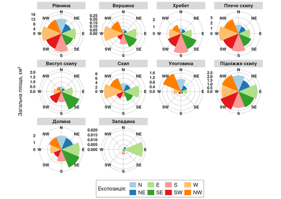
#WIP - decided to apply the tiniest dash of cartography rather than bashing out screenshots. The "Aussie ATES" story is inching toward publication... Here you see Australia's largest concentration of "Extreme" terrain...

#WIP - decided to apply the tiniest dash of cartography rather than bashing out screenshots. The "Aussie ATES" story is inching toward publication... Here you see Australia's largest concentration of "Extreme" terrain...
There are many ways to represent the spatial anisotropy of terrain forms.
In this case, I focused on a comparative approach: the real surface area of different geomorphon classes plotted against slope aspect.
All calculations were performed within the polygon of the effective catchment area of the Inhulets River.
This visualization highlights how specific landform types tend to “align” with certain aspect directions, revealing structural asymmetries within the catchment.
#Geospatial #Geomorphometry #TerrainAnalysis #RStats #DataViz #Hydrology #SAGA #EnvironmentalScience #GIS #RemoteSensing #InhuletsRiver #ggplot2 #Copernicus #CopernicusDEM #Geomorphology
✨Novel data, methods and applications in Geomorphometry: 𝗰𝗮𝗹𝗹 𝗳𝗼𝗿 𝗮𝗯𝘀𝘁𝗿𝗮𝗰𝘁𝘀 for the 23rd annual meeting of the Asia Oceania Geosciences Society in Japan!
Session listed as IG38: Interdisciplinary Geosciences, and it is organized by Massimiliano Alvioli, Takashi Oguchi, Mio Kasai, Cheng-Zhi Qin, and Li-Yang Xiong
𝗦𝗲𝘀𝘀𝗶𝗼𝗻 𝗱𝗲𝘀𝗰𝗿𝗶𝗽𝘁𝗶𝗼𝗻: https://lnkd.in/d9KcjVJV
The 𝗱𝗲𝗮𝗱𝗹𝗶𝗻𝗲 for submission and request for 𝗳𝘂𝗻𝗱𝗶𝗻𝗴 𝘀𝘂𝗽𝗽𝗼𝗿𝘁 is January 23, 2026
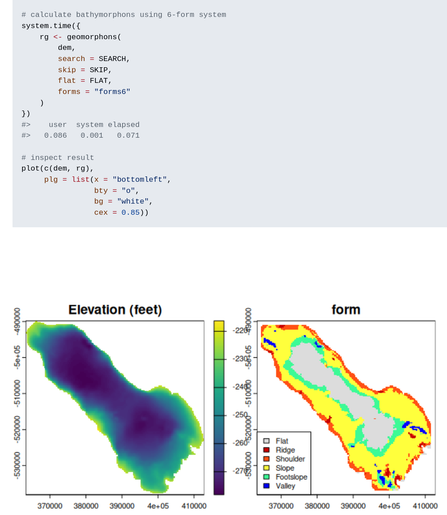
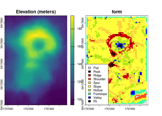
New R package: rgeomorphon 📦 by Andrew Brown
Classifies terrain forms using a parallel C++ implementation of the geomorphon algorithm.