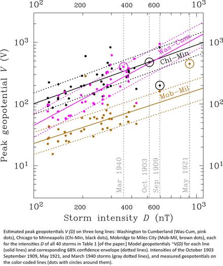
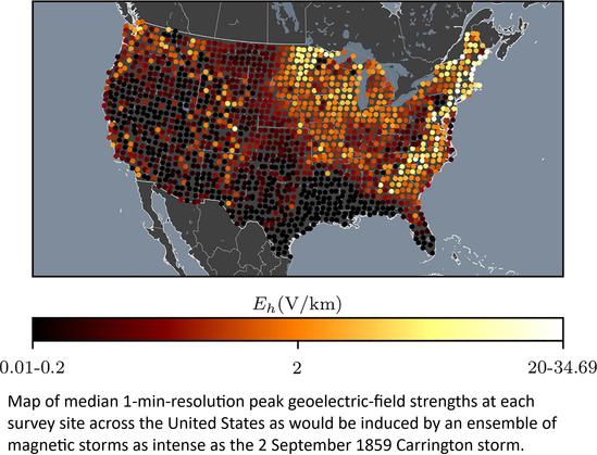
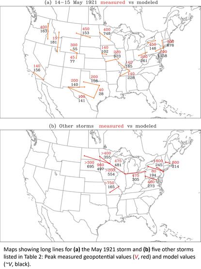
Basics of Numerical Weather Prediction (NWP):

1. THE HORIZONTAL MOMENTUM EQUATION:
\[
\frac{d\mathbf{V}}{dt} + f\hat{k} \times \mathbf{V} = -\nabla \phi + \frac{\sigma}{p_s} \frac{\partial \phi}{\partial \sigma} \nabla p_s + \mathbf{F}
\]

2. THE CONTINUITY EQUATION:
\[
\frac{\partial p_s}{\partial t} + \nabla \cdot (p_s \mathbf{V}) + \frac{\partial}{\partial \sigma}(p_s \dot{\sigma}) = 0
\]

3. THE THERMODYNAMIC ENERGY EQUATION:
\[
\frac{1}{R} \frac{d}{dt} \left[ \sigma \frac{\partial \phi}{\partial \sigma} \right] + \frac{RT}{C_p p} \left[ p_s \dot{\sigma} + \sigma\dot{p_s} \right] = -Q
\]

4. HYDROSTATIC EQUATION:
\[
\frac{\partial \phi}{\partial \sigma} = -\frac{RT_v}{\sigma}
\]

5. SURFACE PRESSURE TENDENCY EQUATION:
\[\displaystyle
\frac{\partial p_s}{\partial t} = -\int_{0}^{1} \nabla\cdot (p_s \mathbf{V}) \, d\sigma
\]

6. MOISTURE EQUATION:
\[\displaystyle
\frac{\partial}{\partial t} (p_s q) + \nabla\cdot (p_s q \mathbf{V}) + \frac{\partial}{\partial \sigma} (p_s q \dot{\sigma}) = p_s S
\]

The six primary unknowns are: \(\mathbf{V}\) (horizontal wind velocity), \(p_s\) (surface pressure), \(T\) (temperature), \(q\) (specific humidity or moisture), \(\phi\) (geopotential), and \(\dot{\sigma}\) (sigma velocity or vertical velocity in \(\sigma\)-coordinates).

#NWP #Weather #NumericalWeatherPrediction #Meteorology #Climate #ClimateScience #Earth #EarthScience #ClimateChange #ClimateSciences #Science #WeatherPrediction #Humidity #Moisture #Pressure #Velocity #SurfacePressure #HydrostaticEquation #WeatherPrediction #Ocean #Atmosphere #AOS #ClimateDynamics #WeatherDynamics #Geopotential #SigmaVelocity #VerticalVelocity #MoistureEquation #Thermodynamics #Dynamics #NavierStokes

Climate change supercharged a heat dome, intensifying 2021 fire season, study finds

As a massive heat dome lingered over the Pacific Northwest three years ago, swaths of North America simmered—and then burned. Wildfires charred more than 18.5 million acres across the continent, with the most land burned in Canada and California.

Phys.org
Moving mountains: reevaluating the elevations of Colorado mountain summits using modern geodetic techniques - Journal of Geodesy

One of the most challenging environments for accurate geoid models is in high, rugged mountain areas. Orthometric heights derived from GNSS and a geoid model can easily have errors at the decimeter level. To investigate the effect of geoid model variability on the elevations of peaks in high, rugged mountain areas, this paper is focused on the “Fourteeners” of Colorado, USA (a group of about 60 peaks that are above 14,000 feet = 4267.2 m). Airborne LiDAR data are used to determine geometric (ellipsoidal) heights, which first requires removing a hybrid geoid model, as the LiDAR data is originally provided as orthometric heights. We quantify a significant improvement when using these derived ellipsoidal heights compared with the original orthometric heights: from ± 0.074 to ± 0.054 m (RMSE), an improvement of 28%. Next, a mean geoid model is determined with a relative accuracy of ± 0.06 to 0.08 m and used as a “stand in” realization of the future, official geopotential datum of the USA, NAPGD2022. Using the LiDAR ellipsoidal heights and geoid model, elevations (and uncertainties) for each of the Fourteener summits are determined and found to be, on average, 1.6 m lower than currently published values. This is a much larger change than the 0.5 m decrease expected from the new datum shift alone. The bulk of the difference is due to the original treatments of the vertical angle, triangulation data. A reanalysis of 32 of the 60 peaks shows that the historic data were indeed too high by about 1.0 m or more. Ultimately, no peak falls below the 14,000-foot level nor are any peaks elevated above this level.

SpringerLink