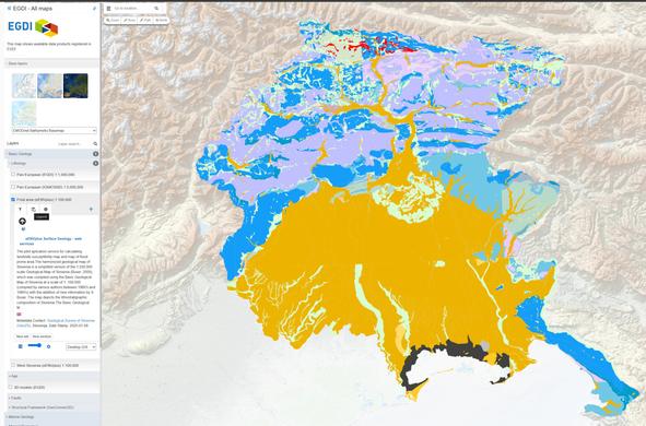
Map Viewer - EGDI

Powerful and easy-to-use online application to display, query and analyse geological information through interactive maps.

EGDI
Latest Earthquakes Interactive [Global] Map – USGS
--
https://earthquake.usgs.gov/earthquakes/map/ <-- shared global map
--
https://www.usgs.gov/programs/earthquake-hazards <-- USGS earthquake hazards home page
--
“The USGS monitors and reports on earthquakes, assesses earthquake impacts and hazards, and conducts targeted research on the causes and effects of earthquakes. [They] undertake these activities as part of the larger National Earthquake Hazards Reduction Program (NEHRP)…”
The interactive map shows “Latest earthquakes map and list (past 24 hours, M2.5+) from the ANSS (Advanced National Seismic System)…”
#GIS #spatial #mapping #earthquakes #webmap #onlinemap #mapportal #earthquake #earthquakehazard #risk #hazard #catalogue #impacts #cause #effect #geology #engineeringgeology #global #USGS #NEHRP #ANSS #seismicity #mitigation
@USGS
Latest Earthquakes

A New Interactive [Mapping] Research Tool For The Antarctic Sea-Ice Zone [Nilas]
--
https://phys.org/news/2023-02-interactive-tool-antarctic-sea-ice-zone.html <-- shared article
--
https://nilas.org/#1/-90/0 <-- NILAS software
--
“The Southern Ocean Mapping Platform - Nilas is a mapping tool (beta) which displays multiple layers of physical and biogeochemical variables. The data displayed are primarily derived from remotely sense products and updated as source data becomes available. The Australian Antarctic Division developed this tool to cover the Antarctic sea-ice zone and to support their research and operational activities…"
#GIS #spatial #mapping #Nilas #marine #data #research #planning #science #Antarctic #seaice #geospatial #ice #climatechange #water #hydrology #hydrospatial #SouthernOceanMappingPlatform #mapportal #opendata #SouthernOcean #spatiotemporal #historicdata #climateresearch #climate #chlorophyll #phytoplankton #seasurfacetemperature #Antarctica #ecosystem #spatialanalysis #remotesensing #satellite #instrumentation
A new interactive research tool for the Antarctic sea-ice zone

A new interactive Antarctic map promises to assist voyage planning and enhance climate research in the sea-ice zone, by bringing together Southern Ocean data from the past four decades.

Phys.org