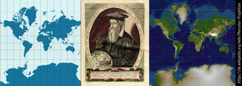
Today is one of those days where I wonder what has become of my life #gischat

In today's #gleo news: the `dotFramify` decorator.

It's another tool for debugging #webgl, in those instances where a particular browser+GPU combination misbehaves, and you need to see the vertices in a kind of "dot frame" in addition to the "wireframe".

#gischat

Na, wer kennt es? ST_Letters, ein Text2Multipolygon / Well, who’s familiar with it? ST_Letters, a Text2Multipolygon https://geoobserver.de/2026/04/07/na-wer-kennt-es-st_letters-ein-text2multipolygon/ #PostGIS #PostgreSQL #gistribe #gischat #fossgis #foss4g #OSGeo #spatial #geospatial #opensource #mapping #gis #geo #geoObserver pls RT @astroidex
A new VerySpatial podcast is out! A VerySpatial Podcast – Episode 782, listen to it here: https://veryspatial.com/2026/04/a-veryspatial-podcast-episode-782/
#GIS #GISChat
A VerySpatial Podcast - Episode 782

BayGeo from AAG conference

geoparquet-io: Fast #GeoParquet tool: geoparquet-io is an open-source #CLI tool and #Python library for converting, inspecting, optimizing, and partitioning #GeoParquet files, automatically applying GeoParquet performance best practices along the way. Its extract command can pull geodata from sources such as #WFS, #Esri ArcGIS Feature Services, or #BigQuery into GeoParquet.
https://spatialists.ch/posts/2026/04/06-geoparquet-io-fast-geoparquet-tool/ #GIS #GISchat #geospatial #SwissGIS
geoparquet-io: Fast GeoParquet tool – Spatialists – geospatial news

#geoparquet-io is an open-source #CLI tool and #Python library for converting, inspecting, optimizing, and partitioning #GeoParquet files, automatically applying GeoParquet performance best practices along the way. Its extract command can pull geodata from sources such as #WFS, #Esri ArcGIS Feature Services, or BigQuery into GeoParquet.

Spatialists – geospatial news
A very detailed shaded map of Duluth, Minnesota, US. The full map is 25000 x 25000 pixels with 0.5 m resolution and is available at https://shadedmaps.github.io
Data source: https://apps.nationalmap.gov [U.S. Geological Survey, National Geospatial Program].
#GIS #gischat #shadedmaps #dataviz #geography
A very detailed shaded map of Szczecin, Poland. The full map is 20000 x 20000 pixels with 0.5 m resolution and is available at https://shadedmaps.github.io
Data source: https://www.geoportal.gov.pl [Head Office of Geodesy and Cartography].
#maps #shadedrelief #GIS #gischat #geography