J9C   

@J9C@mapstodon.space
226 Followers
245 Following
731 Posts
Marine Biologist | GIS Analyst | Humanitarian Mapper
Technical Account: Toots are mine.
Accessibility A11y: Toot + image + Alt text = Boost
Interests: #STEM #remotesensing #lidar #geology #python #EarthObservation #marinebiology #starwars #humantarianmapping #horses
Header: Landsat 8 image of the Appalachian region
Avatar: Map pin in a circle with a map background
Social Account: @EquineJ9
PronounsShe / Her
OSMhttps://www.openstreetmap.org/user/Codesurfer
Do you already contribute to @openstreetmap? You can start contributing to OpenHistoricalMap too in just a few clicks, without having to juggle yet another password for yet another mapping site. Once you have a taste of OSM #SingleSignOn via #OAuth2, you’ll never look back.

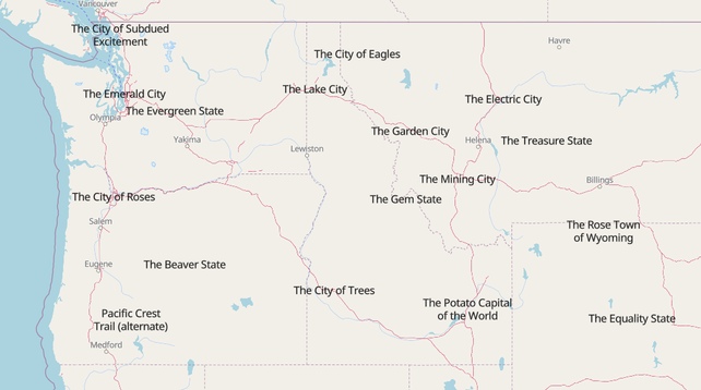
Does your city/state/country have a well established nickname? Make sure it is added to OpenStreetMap using the nickname tag!

It's quite fun to see everything rendered in a less "official" fashion.

#nicknames #OpenStreetMap

https://overpass-ultra.us/#map&query=gist:1d3d4d0698f7163abdeea59846a6e2c1

State of the Map US is next week and instead of finishing my slides I am making fun buttons. Come find me at the conference and you too can have a fun button!

#sotmus #openstreetmap

Has anyone used #easymap or knows someone who has? A friend would be interested in having a short interview with someone who uses of used the software.
https://www.easymap.one/

#GIS #gischat #gistribe #QGIS #arcgis #esri

Home

Business Mapping aus einer Hand. Ob schlanke easymap office-Lösung oder easymap enterprise als individuelles GIS: Geomarketing mit easymap macht Ihr Business besser.

easymap.one
Some work in progress this evening. Slowly putting together this plan-oblique view of Isle Royale. Next up I need to finish tidying the joins between rivers and lakes. Then I can start putting in some other points of interest. #IsleRoyale #NationalPark

A visualisation of the wine regions of New Zealand three ways.

#rayshader adventures, an #rstats tale

Tennessee - The Volunteer State

Made with #QGIS and #Blender

#Cartography #Maps #GisChat

Last call for the #Map of the Month subscription by the Independent Map Artists (closes June 15).

https://somethingaboutmaps.bigcartel.com/product/map-of-the-month-subscription

For $40/month, we’ll send you a whole variety of fun and beautiful mappy goods, all while your support helps independent artists. And it makes us happy to know our goods are out there in peoples' homes.

Please share around to make sure no one misses out!

Today I made an account on Liberapay to throw some bucks at all the #Openstreetmap editing apps I use on my phone almost daily. Given how good this makes me feel, it's money well spent!

World population visualisation using Blender.

Data is gridded population data from Kontur, exported from QGIS as a CSV file.