1,000+ newly digitised and georeferenced historical #maps from the ETH Library collection are now online! 🗺️ Take a look!

https://daas.library.ethz.ch/rib/v3/e-maps

#ethlibrary #carte #georeference #geotiff #historicalmaps #bibliothek #library #perpignan #france #opendata #publicdomain #foret

📷 "Essai d'une carte botanique et forestière de la France", Feuille de Perpignan, Paris 1897. ETH Library, Public Domain Mark / OpenStreetMap, 28.05.2025, Lizenz: ODbL 1.0
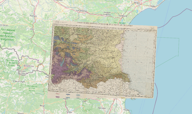
1000+ neue digitalisierte und georeferenzierte historische #Karten aus dem Bestand der ETH-Bibliothek: Schaut rein!

https://daas.library.ethz.ch/rib/v3/e-maps

#ethbibliothek #maps #carte #georeference #geotiff #georeferenzierung #historicalmaps #bibliothek #library #Kartensammlung #perpignan #france #publicdomain #foret

📷 "Essai d'une carte botanique et forestière de la France", Feuille de Perpignan, Paris 1897. ETH-Bibliothek, Public Domain Mark / OpenStreetMap, Stand: 28.05.2025, Lizenz: ODbL 1.0

Hello Mastodon!
I would like some tips about how to georeference a bunch of old aerial photographs with #QGIS. I mean, I know how to #georeference a picture, but how to correlate at a pixel-based level in order to create a continuous mosac image?

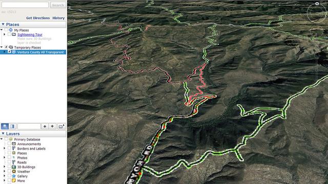
1/3 Got 3D?

#GoogleEarthPro is free software that simulates 3D. It can be installed on PC/Mac/Linux. In addition to the screen controls you can rightclick-hold and slowly move your pointing device.

Here are example #GIS KMZ files for Ventura County, CA.

Trails and roads. Transparent background.
https://mappingsupport.com/p2/kmz_demo/ventura_county_all.kmz 21MB

Trails and roads. Scanned USGS topos.
https://mappingsupport.com/p2/kmz_demo/ventura_county_all_topo.kmz 37MB

#Georeference #Georeferencing #Geospatial #Maps #Mapping

@lapingvino @factotum

Btw, #normalization of #georeference|s is not trivial, because it requires techniques called #InstanceMatching.

It's an entire field of ongoing research.

A search for one of the #Berlin|s should be able to come up with

#QTHJO62
#OLC9F4M

🌺

🏷️ #OLC #QTH #SemanticFediverse #ActivityPub #Mastodon #Friendica #Pixelfed #Fediverse #Geocode #Georcoding #Georeferencing #OpenLocationCode #PlusCode #Maidenhead #HamRadio #AFU #CBFunk #CitizenBand #CiBi #ActivityVocabulary

Allmaps is a set of open source tools that make it easier and more fun to search, explore, georeference and work with collections of digitised maps https://squeet.me/objects/962c3e10e0881b479ce5548db6dc680835c12dcd
Allmaps is a set of open source tools that make it easier and more fun to search, explore, georeference and work with collections of digitised maps

Allmaps works with any image repository that supports the International Image Interoperability Framework (IIIF). By using tiled IIIF images, JavaScript and W...

×

1/3 Got 3D?

#GoogleEarthPro is free software that simulates 3D. It can be installed on PC/Mac/Linux. In addition to the screen controls you can rightclick-hold and slowly move your pointing device.

Here are example #GIS KMZ files for Ventura County, CA.

Trails and roads. Transparent background.
https://mappingsupport.com/p2/kmz_demo/ventura_county_all.kmz 21MB

Trails and roads. Scanned USGS topos.
https://mappingsupport.com/p2/kmz_demo/ventura_county_all_topo.kmz 37MB

#Georeference #Georeferencing #Geospatial #Maps #Mapping