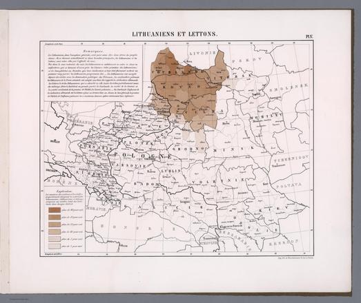
Rastvorennyy kislorod. Velichina PH. Velichina PH. Shchelochno-khlornoy Koeffitsiyent Alk/C 1. (to accompany) Atlas okeanov : Atlanticheskiy i Indiyskiy Okeany 1977. https://www.davidrumsey.com/luna/servlet/detail/RUMSEY~8~1~354900~90121870

#map #maps #HistoricalMaps

Frankreich. Druck und Verlag von Carl Flemming in Glogau. (to accompany) Sohr-Berghaus Hand-Atlas uber alle Theile der Erde. Neu bearbeitet von F. Handtke, Achte vermehrte und verbesserte Auflage. No. 47. Published in 1888. https://www.davidrumsey.com/luna/servlet/detail/RUMSEY~8~1~302152~90073193

#map #maps #HistoricalMaps

No. 58. Schweden und Norwegen, (suedkiche Haelfte), Daenemark, Nord - Deutschland und russusche Ostsee - Lander. Published in 1860. https://www.davidrumsey.com/luna/servlet/detail/RUMSEY~8~1~294691~90065583

#map #maps #HistoricalMaps

Parys, wie solche 1620, im Wessen gelanden. (to accompany) Topographia Galliae ... Het eerste deel. Amsterdam : By de Weduw van Ioost Broersz en Casper Meriaen, 1660. Published in 1663. https://www.davidrumsey.com/luna/servlet/detail/RUMSEY~8~1~312113~90081483

#map #maps #HistoricalMaps

An 1853 map captures the Aral Sea before one of the world’s worst environmental disasters, now revisited in Milan through art, memory, and loss https://ow.ly/unEC50YKwci #AralSea #History #MilanDesignWeek #ArtExhibition #WaterCrisis #EcoArt #HistoricalMaps

1853 Map of the Aral Sea Publi...
1853 Map of the Aral Sea Published in the Journal of the Royal Geographical Society - The Times Of Central Asia

An 1853 map of the Aral Sea, published in the Journal of the Royal Geographical Society, depicts the vast inland water body at a time when it was near its

The Times Of Central Asia
An 1853 map captures the Aral Sea before one of the world’s worst environmental disasters, now revisited in Milan through art, memory, and loss https://timesca.com/1853-map-of-the-aral-sea-published-in-the-journal-of-the-royal-geographical-society/ #AralSea #History #MilanDesignWeek #ArtExhibition #WaterCrisis #EcoArt #HistoricalMaps