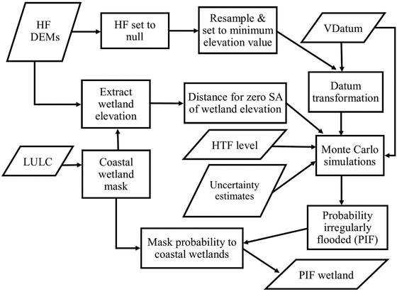
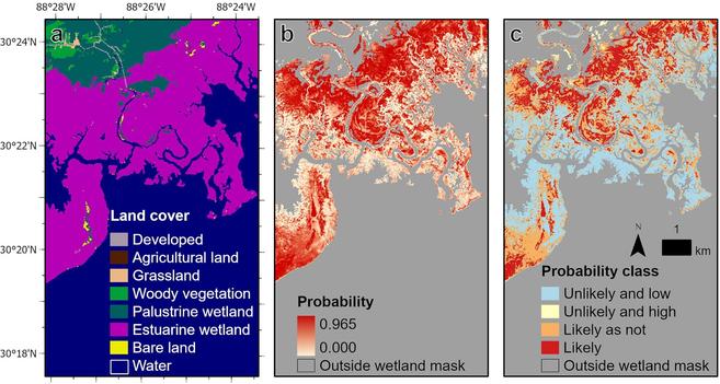
Elevation-Based Probabilistic Mapping Of Irregularly Flooded Wetlands Along The Northern Gulf Of Mexico Coast
--
https://www.sciencedirect.com/science/article/pii/S0034425723000020 <-- shared paper
--
https://doi.org/10.5066/P9MLO26U <-- open access to study’s data
--
#GIS #spatial #probablistic #mapping #coastal #wetlands #elevation #uncertainty #LiDAR #MonteCarloSimulation #spatialautocorrelation #gischat #flooded #flooding #GulfOfMexico #MHW #datum #tidal #ecosystem #wildlife #fish #habitat #erosion #protection #SLR #sealevelrise #climatechange #hydrospatial #extremestorms #stormsurge #management #mitigation #spatialanalysis #spatiotemporal #changecontrol #extremeweather #landuse #landcover #remotesensing #model #modeling #numericalmodeling #probabilisticmap #accuracy #precision #corrleation #errormetrics #statistics #geostatistics #opendata #water #hydrology #data #food #digital
--
https://www.sciencedirect.com/science/article/pii/S0034425723000020 <-- shared paper
--
https://doi.org/10.5066/P9MLO26U <-- open access to study’s data
--
#GIS #spatial #probablistic #mapping #coastal #wetlands #elevation #uncertainty #LiDAR #MonteCarloSimulation #spatialautocorrelation #gischat #flooded #flooding #GulfOfMexico #MHW #datum #tidal #ecosystem #wildlife #fish #habitat #erosion #protection #SLR #sealevelrise #climatechange #hydrospatial #extremestorms #stormsurge #management #mitigation #spatialanalysis #spatiotemporal #changecontrol #extremeweather #landuse #landcover #remotesensing #model #modeling #numericalmodeling #probabilisticmap #accuracy #precision #corrleation #errormetrics #statistics #geostatistics #opendata #water #hydrology #data #food #digital