La Crosse Regional Airport - La Crosse, United States
https://en.wikipedia.org/wiki/La_Crosse_Municipal_Airport
https://www.openstreetmap.org/#map=13/43.879002/-91.256699
#KLSE #LSE #LaCrosse #UnitedStates #airport #aviation #avgeeks #GIS


La Crosse Regional Airport - La Crosse, United States
https://en.wikipedia.org/wiki/La_Crosse_Municipal_Airport
https://www.openstreetmap.org/#map=13/43.879002/-91.256699
#KLSE #LSE #LaCrosse #UnitedStates #airport #aviation #avgeeks #GIS


🚨 Reminder: The deadline for the Call for Proposals for FOSS4G North America is June 30. The time is NOW to submit your talk, workshop, poster, or lightning talk.
#GIS #geospatial #EO #opensource #CNG #LI #opendata
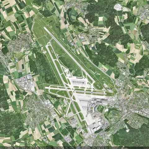
Zürich Airport - Zurich, Switzerland
https://en.wikipedia.org/wiki/Zurich_Airport
https://www.openstreetmap.org/#map=13/47.458056/8.548056
#LSZH #ZRH #Zurich #Switzerland #airport #aviation #avgeeks #GIS

Schluss mit teuren GIS-Lizenzen. Zeit für QGIS. 🗺️
QGIS ist vollwertig, frei & OGC-konform. Mit Editierung, breiter Formatunterstützung, Plugins und Serverfunktionalität.
Einführungsschulung – Schritt für Schritt von der Installation zur fertigen Karte:
✅ Viewer, PostGIS, WMS/WFS
✅ Unterschiede zu ArcGIS
✅ Darstellung, Plugins & Mapcomposer
2 × 3 Std. online | Fragen live klärbar
📆 25.-26. August 2026
🕙 09:00-12:00 Uhr
📍 Online


Islamabad International Airport - Attock, Pakistan
https://en.wikipedia.org/wiki/Islamabad_International_Airport
https://www.openstreetmap.org/#map=13/33.549000/72.825660
#OPIS #ISB #Attock #Pakistan #airport #aviation #avgeeks #GIS


🏔️ Big Freemap update for outdoor folks — and anyone with map files!
🗺️ The file import now takes multiple GPX/GeoJSON/KML/KMZ/TCX files at once & merges them; elevation profile & details work for multi-track and interrupted recordings too
🎨 Colorize tracks by elevation, speed, steepness & more
📈 Elevation profile now shows waypoints with labels
💾 Save tracks to your My Maps
🔬 Keeps every recorded channel (HR, power, temp…)


Vorige week vrijdag kwamen collega’s uit 25 gemeenten samen in het stadhuis van Zaandam voor de #QGIS-gebruikerdag voor gemeenten. We deelden praktijkervaringen met QGIS, terwijl Zaanstad zorgde voor ☕🍪 en 🍦 bij de borrel.
De diversiteit aan QGIS‑toepassingen blijft verrassen: van dataverrijking tot slimme visualisaties voor data‑gedreven werken.
🏛️ Dank aan #GemeenteZaanstad voor het hosten!