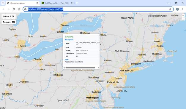
🚀 QGIS2VectorTiles v2.0 is out!

What’s new:

✅ Choose your MapLibre viewer background (project's background color or OpenStreetMap).
✅ Brand new plugin homepage.

🔗 https://gallpeters.github.io/QGIS2VectorTiles/

Do not forget to say goodbye to ESRI’s VTPK and keep spreading the word! 🙂

Go #FOSS !

#gis #qgis #gdal #vectortiles #cartography #geospatial #opensource

🚀 QGIS2VectorTiles v1.9 is out! Here are some improvements since the last release post (v1.6):

✅ Data-defined properties are now implemented as fields in the MapLibre style.
✅ HTTP server now runs silently on Windows.
✅ MapLibre-gl.js is served locally for offline use.
✅ A styling considerations section and more demos were added to docs.

Do not forget to say goodbye to ESRI’s VTPK and keep spreading the word! 🙂

Go #FOSS !

#qgis #gdal #gis #vectortiles #cartogrpahy #geospatial

Neues aus dem #Mapbender-Projekt – Neues Design & mehr Datenquellen 💪

📑 Release 4.2 & der kommende Major Release 5.0 bringen spannende Neuerungen:
• Modernisiertes Frontend-Design
• Absicherung einzelner Datenquellen
#VectorTiles & OGC API Features
• Anwendungswechsler & Seriendruck

👀 Live-Demo von Astrid Emde & Thorsten Hack auf der #FOSSGIS2026!

📅 Fr, 27. März | 09:35 Uhr
📍 Raum HS1 (ZHG 011)

👉 https://pretalx.com/fossgis2026/talk/RPVA3K/

#WebGIS #OpenSource #OSGeo #GIS

@mfuhrmann Hm? Erst mal die Gebäude; auch den Übergang. Dann #IndoorMapping der Stockwerke, Räume und Stützen. Gehen indoor da auch Tische? Die Regionen erst mal.
Weiter als #MicroMapping für die Geleise und Modellgebäude?! Da in #OpenStreetMap alles geht, geht auch alles in Miniatur. Was zeigen die 2D/3D Renderer da noch alles an? Terrain ist bei OSM ja noch mangelnd. Wie gehen in "echt" Tunnel und Berge? Selbst wenn 3D die height-tags berücksichtigt werden.
Die Standard- #VectorTiles reichen jedenfalls nicht. Aber man kann ja Zusätzliche parallel generieren.
Das #MiWuLa wäre eine Schweine-Arbeit! Wenn sie helfen, mit Plänen und Dateien, wird es 50% leichter. Hat schon mal jemand von #OSM mit denen gesprochen? Einfach mal fragen ...
Einige Teile sind ja 1:1 nach gebaut, also in OSM schon vorhanden. Könnte man kopieren.
Es gibt 3D Renderer, wo Autos fahren. Züge noch nicht, gell? Dafür FOSS-Bahn-Spiele. Und das dann in der VR-Brille - wild zu einem virtuellen Rundgang. Träum ...

🚀 QGIS2VectorTiles v1.2 is out!

✅ Full support for #QGIS data-defined properties (symbols and labels)
✅ Improved centroid label generation (choose whether labels are based on the whole polygon or only the visible part)
⏩ Next step ➔ Generating #MapLibre sprites 🔥

#VectorTiles #GIS #FOSS #Geospatial #GDAL #Cartography #wms #wmts

https://github.com/GallPeters/QGIS2VectorTiles

The main #VectorTiles tileset contains route information for more informative transportation map styles. A new tileset contains territories as polygons, so your custom map can color in a country or other administrative region.

🚀 Introducing QGIS2VectorTiles!

#QGIS plugin which turn your project into a lightweight #VectorTiles package for WMS/WMTS serving or easy sharing.

✅ Converts all vector sources to a single .mbtiles/XYZ using #GDAL.
✅ Preserves rich styling (renderers, labeling, expressions etc).
✅ Generates a .qlr for easy sharing.
⏩ Generates a client-side #MapLibre styling (In Dev).

Thanks to @underdarkGIS @nyalld @EvenRouault & all #FOSS #GIS community that made this possible!

https://plugins.qgis.org/plugins/QGIS2VectorTiles/

Inzwischen liegt der Mapbender in der Version 4.2.4 vor 📣 und es gibt diverse Neuerungen - Routing mit Export, sekundengenaue Aktualisierung für WMS-Dienste, Filter im Ebenenbaum, Vector Tiles u.v.m..

Einen tiefen Einblick in alle Details bietet der ausführliche Blogartikel unserer Kollegin @Astrid Emde aus dem Mapbender-Team – jetzt reinklicken 👇
https://wheregroup.com/blog/details/mapbender-4-neuerungen-und-praxisbeispiele/

#Mapbender #WebGIS #OpenSource #VectorTiles #Routing

Die @foss_academy Termine 2026 für unsere Web-Seminare sind Online.

Wir bieten jeweils am 1. Donnerstag im Monat ein kostenloses einstündiges Web-Seminar an.
👉 10.00 - 11.00 Uhr

Es geht um #MapServer #WMS Time #PostGIS #PostgreSQL #QGIS #Python #Mapbender #GeoServer #VectorTiles #OGC API #MapComponents & mehr

Jetzt schon anmelden!
👉 https://foss-academy.com/web-seminare/
#FOSSGIS #OSGeo #GIS #GEOSPATIAL #FOSS4G #WebGIS

#30DayMapChallenge – Day 13: 10 minute map Map of the #Mara River Basin made in #QGIS with #HydroSHEDS #opendata and @maptiler.bsky.social #vectortiles. 🎥 Try it for your own catchment: youtu.be/hUgEYKz87gw