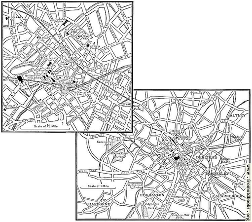
https://www.fromoldbooks.org/Cassell-TheBritishIsles/pages/v2s2-336-map-of-old-birmingham/

Birmingham city centre was largely destroyed by heavy bombing in the Second World War, and has both suffered through and benefited from extensive reconstruction since.

This #map was published in 1905 and thus shows #Birmingham well before the bombing or any modern changes.

#vintageMap #map #streetMap #birmingham #fobo #vintageArt #prewar #GIMP #GIMP3 #Gimp_3

10 dagen geleden aangemaakt door Kapitein Generaal Loncke #streetmap

30 minuten geleden opgelost door Tjuro

Locatie: 52,2709362; 6,1169091

Buitenplaatsen in Nederland - Buitenplaats Ter Cera | Buitenplaatsen in Nederland
Ligging Terwolde - Bandijk 15 Geschiedenis Na 1628 (het jaar van de Spaanse Zilvervloot) is het huis gebouwd, evenals het bekende Matanze .

#AllardPierson #Museum #Cartografie #Atlas #StreetMap

In het Allard Pierson Museum gingen we naar Open Kaart: van atlas tot streetmap.
Een vrij kleine tentoonstelling, maar genoeg om van onder de indruk te zijn. Zoals Depictions of Amsterdam van Gert Jan Kocken, en de spotprenten van Europa, die ik nog niet eerder had gezien. Nog t/m volgende week. Tip!

https://allardpierson.nl/events/open-kaart-van-atlas-tot-streetmap/

Open Kaart – van atlas tot streetmap

Open kaart  toont zeven eeuwen cartografie in Nederland Γ©n werpt een blik in de toekomst. De tentoonstelling laat een enorme diversiteit aan kaarten zien vanaf de 15de eeuw en deelt de verhalen die erachter schuilgaan. Alle kaarten, waaronder werk van...

Allard Pierson
Streetmaps

Streetmaps

Hey y'all what interchange is this? Image is from 2012 or earlier

#ATL #urbanism #plat #streetMaps #streetMap #atlanta

https://mastodon.world/@urbandata/109532159676206226

Mark Abraham (@[email protected])

Attached: 1 image The entire city of Florence, Italy could fit within this highway interchange in Atlanta. https://usa.streetsblog.org/2014/06/13/the-whole-city-of-florence-could-fit-inside-an-atlanta-interchange/ #firenze #urbanplanning #urbanism #highwayremoval #cities #walkability #sustainability #climatecrisis #sprawl #atlanta

Mastodon

MapComplete is a web-based OpenStreetMap graphical inteface which lets you view themed maps and edit them with an OSM ID. You can follow at:

➑️ @MapComplete

The project's website is at https://mapcomplete.osm.be

MapComplete runs on free open source software, the source is at https://github.com/pietervdvn/MapComplete

#MapComplete #OpenStreetMap #OSM #Map #Maps #Mapping #StreetMap #StreetMaps #Travel #FOSS #FLOSS #Libre #FreeSoftware #OpenSource

Google Maps

Find local businesses, view maps and get driving directions in Google Maps.